Green waters supplies terrestrial ecosystems and rain-fed agriculture through soil moisture and it is also green water the one that evaporates from plants and water surfaces to the atmosphere as water vapor. |
Blue waters are directly related to aquatic ecosystems and flow as surface water masses and aquifers. |
The storage capacity of the nearly 4 thousand dams currently existing is 150 cubic kilometers, equivalent to 40% of the average annual runoff in Mexico. |
In Mexico, the natural per capita water availability in the year 2007 was 4 thousand 312 cubic meters per year, which is considered as a low availability. |
Mexico, with an estimated degree of pressure of 17% in 2007, is included under the moderate pressure category, with broad regional variations. |
| CHAPTER 6. WATER |
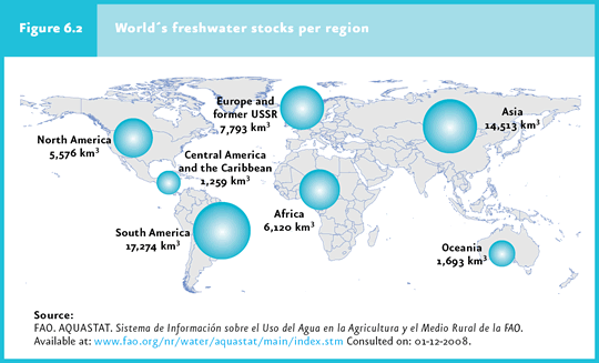
Regional water balance The distribution of precipitation and evapotranspiration varies substantially between the Earth regions, translating into different volumes of water being available in each of them. South America and Asia are the regions with the largest renewable water resources, whereas Oceania and the Caribbean region posses the smallest volumes (Figure 6.2).
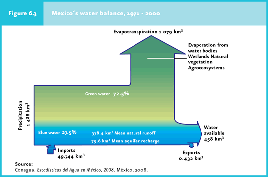
In Mexico, the average water volume obtained from precipitation is one thousand 488 cubic kilometers per year, but most of it, one thousand 79 km3 (72.5%), returns to the atmosphere through evapotranspiration (called “green water” by Falkenmark and Rockström, 2004; Cuadro D3_AGUA01_04). In addition to the water entering through precipitation, Mexico receives 49.744 km3 as import from rivers draining into Mexico from the Northern and Southern borders, and exports 0.432 km3 from the Bravo River to the United States, according to the Treaty on International Water Distribution signed between these two countries in 1944. In this way, the general balance shows that the average natural water availability in Mexico is 458 cubic kilometers of water per year (Figure 6.3); this figure is far higher than that for most European countries, but far lower than the figure for the United States (3 mil 51 km3), Canada (2 mil 902 km3) or Brazil (8 mil 233 km3; FAO, 2007).
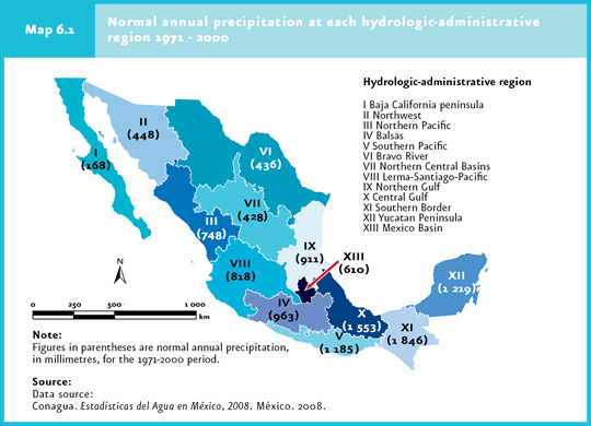
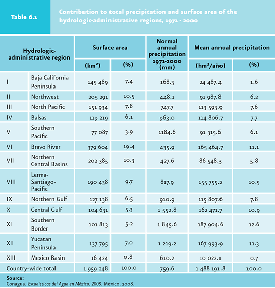
Spatial and temporal variability of water availability In Mexico the mean annual precipitation during the period 1971-2000 was 760 millimeters, a volume that is deemed abundant (CNA, 2008). However, this figure is hardly representative of the hydric situation throughout the country. In states such as Baja California Sur, a mere average of 161 millimeters of precipitation per year are recorded, whereas it reaches up to 2 thousand 102 millimeters in Tabasco (Cuadro D3_AGUA01_01). Considering the hydrological-administrative regions defined by the National Water Commission (Conagua in Spanish), the differences are also evident (Map 6.1). Regions I, II, III and VI, located in the Northern part of the country comprise 45% of the country’s territory but receive 26.5% of the total precipitation. By contrast, administrative regions IV, V, X, XI and XII, located in the Southern part of the country comprise 27.6% of the territory butreceive an average of 48.7% of total rainfall (Cuadro D3_AGUA01_02; Table 6.1).
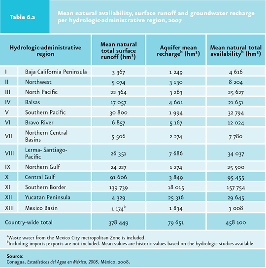
Surface runoff1 also shows important geographical variations across the country. Of the average volume of water available, 83% (378.4 km3) runs off superficially and the rest (79.6 km3) enters the aquifers. Approximately 37% of the national total runoff takes place at the Southern border region, basically through the Grijalva and Usumacinta Rivers, whereas the Baja California and Yucatan peninsulas have a minimal surface runoff, near 1%. In the case of Baja California, this is due to the scarce precipitation, while in Yucatan it is the result of a flat relief and permeable substrate which restrain the formation of surface runoff of any importance (Table 6.2; Cuadro D3_AGUA01_08). Nevertheless, the Yucatan plain favors groundwater recharge.
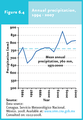
Most of the country’s surface runoff is channeled through the large rivers: jointly, the seven most important rivers (Grijalva-Usumacinta, Papaloapan, Panuco, Coatzacoalcos, Balsas, Santiago and Tonala) catch 65% of the surface runoff (Cuadro D3_AGUA01_05). In the same way as the average precipitation and runoff figures do not reflect the spatial heterogeneity of Mexico, these do not show temporal variations either. In 2004, for instance, precipitation was nearly 15% above the 1971-2000 average, whereas in 1994, 1996, 1997, 1998 and 2002 it remained below 760 millimeters. In fact, considering the whole country, between 1994 and 2002, the average precipitation was below the historical mean, whereas between 2003 and 2007 this figure exceeded the 1971-2000 average (Figure 6.4).
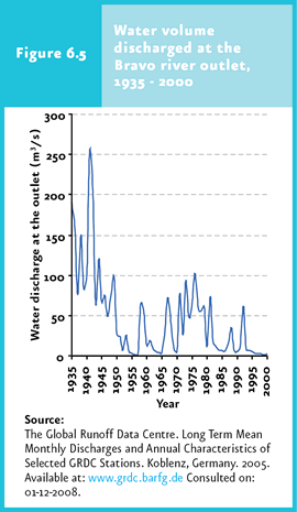
These variations in precipitation translate in events like draught, which may in turn lead to important economic consequences, mostly on agriculture and ranching. Over the past century the country experienced four major draught events: 1948-1952, 1960-1964, 1970-1978 and 1993-1996, as well as a severe draught in 1998, which affected mostly the Northern states. Between the years 2000 and 2003, 18 states were affected by draught. According to the National Center for Disaster Prevention (Cenapred), these suffered economic losses amounting to over one thousand 800 million pesos. Only in 2002 and 2003, nearly one million hectares of crops were affected, and more than 13 thousand head of cattle were lost. The states most severely affected over the last years were Chihuahua, Sinaloa, Zacatecas, Veracruz and Sonora (Cenapred, 2001, 2002, 2003 y 2004). Along with the inter-annual variation in precipitation, the variation occurring between months should also be considered. In the country, 68% of the normal monthly precipitation falls between June and September (Cuadro D3_AGUA01_03), thus affecting the temporal availability of water in many areas of the country, particularly in those located in arid zones. As a result, nearly all rivers show substantial differences in the volume of water they carry between the rainy and the dry seasons. This variation becomes aggravated by the water retention and irrigation works, so that many rivers that were previously permanent have become intermittent, at least in some parts of their course, or have a flow that has significantly decreased. One example is the Bravo River which, after the construction of dams (some of which are classified as “large dams”, including La Amistad y Falcon) along its main course and its tributaries, underwent a significant reduction in its water flow, which sometimes is nil at the river mouth (Figure 6.5).
Cyclones periodically affecting Mexico’s littorals also modify the temporal volume of rain falling throughout the country. In Mexico, more than 25 cyclones with winds of over 63 kilometers per hour, affect the country every year mostly (60% of the total) along the Pacific coast. On average, four of those cyclones have important effects on the territory (Cuadro D1_DESASTRE00_01). Tropical cyclones mostly occur between May and November, with heavy rainfall over short periods of time that substantially increase the amount of water falling on certain areas. However, the water brought in by these meteors, in addition to frequently causing floods and damage to population centers, in many cases cannot be used, as it rapidly runs off to rivers or directly to the sea.
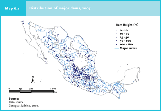
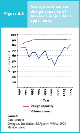
Natural availability There are several ways to estimate water availability in a given country or region, although the precision and realism of the calculated value depend on the information available. A rough approximation is total precipitation. In this respect, the 760 mm of rain that fall over the country make it, according to the OECD, to be included in the list of countries with abundant water availability. However, as mentioned above, the high evapotranspiration rate (72.5% of total precipitation) and the geographical heterogeneity significantly reduce the volume of water that is actually available in different parts of Mexico. The total volume of renewal water resources in Mexico amounts to 458 km3 (volume of available water), which is usually calculated as the sum of the mean annual natural runoff plus the mean recharge of groundwater. It should be noted that this amount not only comprises the water available for human use but also the amount of water required for the maintenance of aquatic ecosystems. For this reason, the volume of water that can be used and is available as a resource to meet the society’s demand is, in reality, considerably lower than the maximum amount of water calculated for each country. In order to ensure the water supply for the different uses throughout the country, and considering the spatial and temporal heterogeneity in precipitation, an important hydraulic infrastructure network of dams and impoundments has been built. With the exception of the Yucatan peninsula, where there are no surface water currents, dams occur throughout all the other administrative hydrological regions (Map 6.2). The storage capacity of the nearly 4 thousand dams in the country (667 of which are classified as large dams according to the criteria International Large Dap Commission´s criteria) is 150 cubic kilometers (IB 2.1-9), equivalent to 40% of the average annual runoff in Mexico.
By contrast, the volume of water stored in lakes and lagoons in Mexico is small (a little over 6.5 km3), since Mexico has no large and deep lakes (Cuadro D3_AGUA01_06). It should be noted, however, that not all the water stored in dams and other impoundments is devoted to consumptive use (that is for agricultural, household or industrial uses): Almost 80% of the water is discharged to the sea without having being uses. Furthermore, it is worth noting that a large amount of the water stored in these reservoirs evaporates to the atmosphere, and the evaporation may even exceed the joint needs of industry and household consumption, which is exacerbated in tropical regions. With regard to the use of dams in the country, considering the 52 largest dams, 25 are devoted to more than one use, 26 are dedicated to electricity generation, 39 are used for irrigation and 9 are dedicated to public water supply and/or flood control. In all, 6.5 million hectares of irrigated agriculture and 2.5 million hectares of technified rain-fed agriculture are served by the hydraulic infrastructure. The amount of water stored in dams varies between years, mainly due to precipitation and water demand (Figure 6.6). Between 1990 and 2002, the volume of water stored in the major dams in Mexico showed a decreasing trend, recovering afterwards and reaching 80 thousand 876 million cubic meters in 2007 (Cuadro D3_AGUA01_07; IB 2.1-9). When the national geography is taken into account, the storage volume is heterogeneous. 18 percent of the water stored in Mexico is located in areas over 500 meters above sea level, despite the fact that over 75% of the population and the country´s largest areas of irrigated agriculture are located in those zones.
Besides the positive effects of dams (e. g. through the continued water supply, flood control and energy generation, mainly) these also cause negative environmental effects, including the fragmentation of ecosystems located along the rivers banks (with the consequent loss of biodiversity), alteration of water quality, loss of environmental services in the flooded basins and the loss of sediments in coastal areas that are captured behind the dam curtains (MEA, 2005). Furthermore, stagnating water may increase the incidence of insect-borne diseases leading to public health issues.
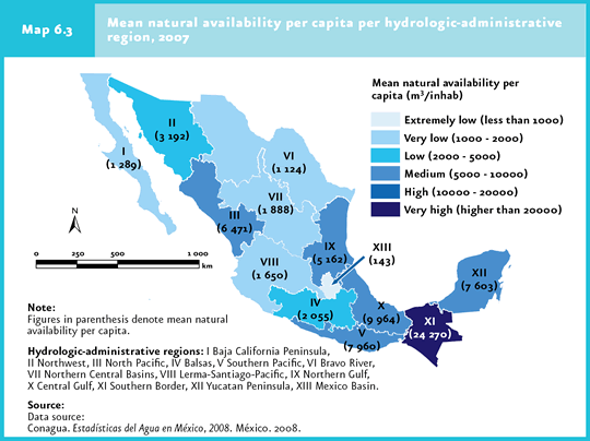
Per capita water availability Another way to assess water availability is considering the volume that corresponds to each inhabitant (IB 2.1-5). The measure clearly depends on the size of the population living in the country or region for which this figure is to be estimated, assuming that precipitation remains constant between years. At the world level, a decreasing trend in the per capita water availability has been observed. In 1960, 11 thousand 300 cubic meters corresponded to each citizen per year, which were reduced to only 5 thousand 600 in the year 2000 and, according to the projections, may decrease further to only 5 thousand by the year 2010 (MEA, 2005). In Mexico, considering the population size estimate for December 2007, which amounted to a total of 106.23 million persons in the country, the natural per capita water availability was 4 thousand 312 cubic meters per year (IB 2.1-1), a volume that, according to the World Resources Institute (WRI), is considered as a low availability (the lower level to classify the average availability is 5 thousand cubic meters per inhabitant per year). Within the world context, the per capita water availability in Mexico today is far lower than that in countries such as Canada (91 420 m3/inh/year), Brazil (45 570 m3/inh/year) or the United States (10 270 m3/inh/year), and in general the whole of South America, but is slightly higher than the average for European countries. An availability lower than one thousand 700 cubic meters per capita per year is considered as a condition of water stress (Falkenmark indicator; UNDP et al., 2000), in which water shortage for the various water-consuming activities may occur frequently (particularly in countries that are prone to draughts like Mexico). When availability drops below one thousand cubic meters per inhabitant per year, the consequences may be more severe and might seriously compromise food security, the country’s economic development and ecosystems protection. Commonly, under these circumstances water is temporarily scarce in some places and decisions have to be made to prioritize the use of water in agricultural or industrial activities or the water supply to the urban and rural population (FNUAP, 2001). In Mexico, per capita water availability has also decreased through time. In 1950 the average availability was 17 thousand 742 cubic meters per inhabitant, which decreased to a little less than 11 thousand cubic meters in 1960 and to less than 8 thousand cubic meters in 1970. According to projections made by the National Population Council (Conapo in Spanish) for the country’s average population, by 2010 the per capita water availability will decrease to 4 thousand 210 cubic meters, and to only 3 thousand 783 cubic meters per habitant per year by 2030 (Conagua, 2008). As a country-wide approach may mask important situations of hydrological stress, it was recently proposed that water availability be studied at the basin level, or at a scale that more closely considers the water source according to the population using it (UNDP et al., 2000). In this way, if water availability is examined by regions, Mexico displays the whole range of water availability categories. The country can be divided into two broad areas: the Northern, center and Northeastern areas, which concentrate 77% of the population and produce 87% of the gross domestic product, but has only 31% of renewable water; and the Southern-Southeastern region, that is home to the 23% of the population, produces 13% of the GDP and contains 69% of the renewable water. To illustrate the heterogeneity in per capita water availability, the Aguas del Valle de Mexico and the Southern border regions constitute good examples. The per capita availability in the Aguas del Valle de Mexico region is 143 cubic meters per inhabitant per year, which makes this region to be included in the extremely low availability category, whereas the Southern border region, with 24 thousand 270 cubic meter per inhabitant per year, displays a very high availability (Map 6.3, Cuadro D3_AGUA03_01). Taking into a count only those hydrological-administrative regions of the country where water availability is equal to or lower than one thousand 700 cubic meters per inhabitant per year, 60 million inhabitants in the country currently face a situation of hydrological stress.
An investigation aimed to detecting areas where water availability may fall below one thousand 700 cubic meters per inhabitant per year by the year 2025 in different basins from the major rivers of the world (for which reliable information on hydrological and population aspects was available), found that, in Mexico, the Balsas, Grande de Santiago and Colorado River basins might fall in this situation (UNDP et al., 2000).
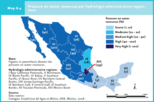
Degree of pressure The degree of pressure on hydrological resources (GPR; IB 2.1-6, IC 10), which represents the proportion of available water that is being extracted in a given area, either for agricultural, public, industrial or other purposes, is another way of assessing water availability. The UN Commission for Sustainable Development (CDS in Spanish) defines four categories of degree of pressure, ranging from a heavy pressure (extraction exceeds 40% of natural availability) to a scarce pressure (the water extracted does not exceed 10% of the available liquid). Mexico, with an estimated GPR of 17% in the year 2007, is included in the moderate-pressure category, above the average of 11.5% for OECD countries (OECD, 2002). Nevertheless, the relatively low GPR for Mexico is influenced significantly by the high water availability in the southern region of the country, since in regions like the Southern Border, Central Gulf, Yucatan Peninsula and Southern Pacific, less than 8% of the water available is extracted. By contrast, the Baja California, North Western, Northern Pacific, Bravo River, Northern Central Basins, Balsas and Lerma-Santiago-Pacific regions, have a drastically different situation, with degrees of pressure above 40% (Map 6.4). A particular case is the Aguas del Valle de Mexico region, where the degree of pressure reached 155% in 2007.
Finally, another way to measure water availability is Use intensity (OCDE, 1998) or per capita extraction. According to this indicator, the per capita extraction in Mexico was 743 cubic meters per inhabitant per year in 2007, a figure similar to those for Italy (774 m3/inh) and Japan (691 m3/inh) and lower than those for the United States (1 596 m3/inh), Canada (1 438 m3/inh), Australia (1 191 m3/inh) and the average for the OECD countries, estimated at around 920 cubic meters per inhabitant per year (OECD, 2003; FAO, 2007).
Note 1Surface runoff refers to the water flow from rainfall, snow melting and other sources on the earth surface.
|