Desertification is the type of land degradation that occurs in arid, semiarid and dry subhumid zones, and may result from factors including climatic variations and human activities. In Mexico, desertification is considered to occur in all ecosystems, but dry ecosystems are deemed the most vulnerable. |
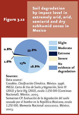
Soil degradation affects 44.2% of Mexico’s drylands. Between 93% and 97% of these are slightly or moderately degraded.
|
Historically, soil has been a natural resource virtually neglected by both government and society, despite that its degradation and desertification involve negative consequences for the environment and population. |
There are a number of institutional programs supporting the implementation of soil conservation actions; however, more specific initiatives are required to offset chemical soil degradation, which is the most widespread type in the country. |
| CHAPTER 3. SOIL |
Although soil supports primary productive activities like agriculture, forestry and cattle raising, its relationship with society is best understood when soil is related to land. The land concept involves many other components besides soil. It is defined as the specific area of the Earth’s crust with specific features in terms of atmosphere, soil, geology, hydrology and biology, as well as those resulting from past and current human activities, and the interaction between all these elements (UNCCD, 1994). The United Nations Convention to Combat Desertification (UNCCD) defined land degradation as “the reduction or loss of economic productivity and complexity of terrestrial ecosystems, including soil, vegetation and other biotic ecosystem components, as well as of ecological, biogeochemical and hydrological processes that take place in them”. In this sense, land degradation involves the degradation of soil, water resources and vegetation, changes in the frequency of fires, disruption of biogeochemical cycles and biological invasions, among other phenomena. When land degradation occurs in arid, semiarid and dry subhumid zones, this phenomenon is denominated desertification, and may result from factors including climate variations and human activities (UNCCD, 1994). In Mexico, the desertification concept has been broadened to encompass all ecosystems, given that land degradation is not restricted to arid, semiarid and dry subhumid areas. However, these are deemed the areas most vulnerable to desertification (Conaza-Sedesol, 1994). Global efforts to fight desertification are led by UNCCD, which became effective during the 1990s. As of March 2008, 193 countries had joined, subscribed or ratified their subscription to this Convention; Mexico ratified its subscription in 1995 (UNCCD, 2008). UNCCD objectives include the combat of desertification and prolonged drought through long-term strategies aiming at improving productivity and achieving the rehabilitation, conservation and sustainable use of land and water resources, to ultimately improve the conditions of people living in desertified areas. Sinades coordinates actions undertaken by several public agencies and social organizations, aimed at containing and reversing desertification, aiming that rural producers, especially in critical zones, adopt production systems and practices oriented to preserving an improving the condition of natural resources through specific policies, instruments and financial resources to offset desertification. Sinades involves the participation of the Boards of the Environment and Natural Resources (Semarnat), Livestock and Fisheries Management (Sagarpa), Social Development (Sedesol), Rural Reform (SRA), Public Education (SEP), Health (SS) and Economy (SE), as well as state governments, rural producers, social organizations, peasants, higher-education and research institutions.
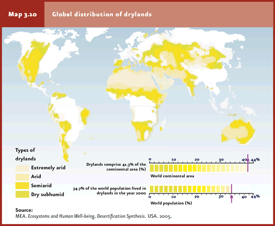
Dryland distribution Arid, semiarid and dry subhumid areas, collectively denominated drylands, are characterized by unique climatic conditions, including scarce and variable precipitation, high or very low temperatures (the latter in cold deserts) and a high potential evapotranspiration. Technically, arid zones are defined as those with an aridity index (calculated as the rate between mean annual precipitation and mean potential evapotranspiration) between 0.5 and 0.65. Based on these values, 30% of the world’s arid zones are located in truly arid, 45% in semiarid and 25% in dry subhumid areas (Reynolds et al., 2005; Map 3.10). Altogether, drylands (including very arid zones)6 comprise 41.3% of the Earth, amounting to 6 thousand 90 million hectares distributed mainly in Asia, North Africa and a large portion of Australia (Map 3.10). Industrialized countries include 28% of total dryland areas, whereas the rest (72%) are located in poor countries (MEA, 2005).
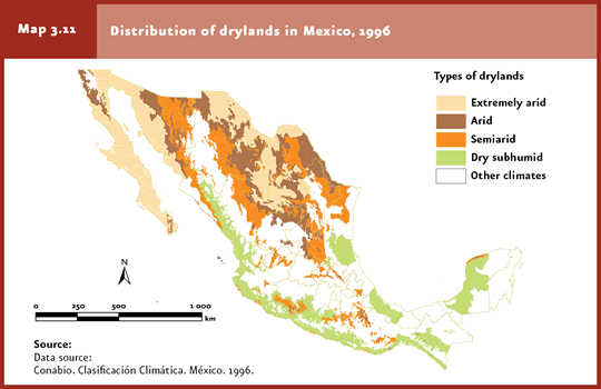
In Mexico7, extremely arid, arid, semiarid and dry subhumid zones stretch over 128 million hectares approximately, that is, more than one half of the country. Very arid and arid zones occur mainly in Baja California, Baja California Sur, Coahuila, Chihuahua and Sonora, accounting for 49% of the country’s total drylands. Semiarid zones represent 29% of the territory, distributed mostly in the Sonoran desert and the states located in the Mexican highlands; 22% corresponds to dry subhumid areas in Campeche and Yucatan, the Gulf of Mexico and the Pacific Ocean coastal plains, from Sinaloa down to Chiapas (Map 3.11).
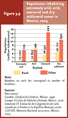
In the year 2000, drylands were populated by 2 thousand million inhabitants, that is, nearly one third of the world’s population (MEA, 2005). In Mexico, 46% of the country’s population (47.7 million persons) lived in these areas in 2005. Of these, 21.8% and 78.2% corresponded to rural and urban population, respectively (Figure 3.9; INEGI, 2006).
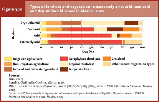
Mexico’s semiarid and dry subhumid zones concentrate some 75% of the population living in drylands, likely because soil productivity is higher in these areas (figure 3.9). In fact, 60% of the country’s agricultural land is located in drylands, with 42% of it located in semiarid areas and 30% in dry subhumid zones (Figure 3.10).
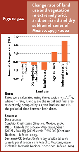
During the period between 1993 and 2002, changes in vegetation cover towards other uses (e. g. farming) in shrublands, rainy and subhumid forests and temperate forests, located mostly in semiarid and dry subhumid areas, accounted for estimated losses in the order of 1.7 million hectares. In parallel, land with grazing potential devoted to cattle grazing expanded at an annual rate of 1.26% over the same period (Figure 3.11).
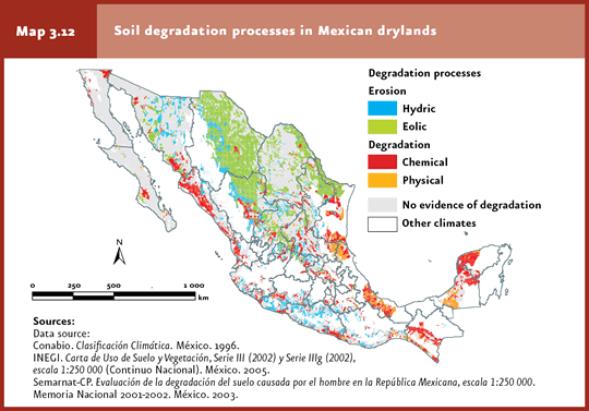
Extent of desertification Estimates on the extent of desertification vary widely according to the calculation method and type of soil degradation included in the assessment. UNCCD estimates that desertification affects between 71% and 75% of the world’s drylands, although this figure has been questioned on the grounds that estimates have considered separately the biophysical factors (erosion or plant cover loss) and socioeconomic aspects (economic losses, production drop, human migrations) associated to desertification; it suffices to point out that both sets of factors are rarely taken together in estimating the extent of desertification (Reynolds et al., 2005). To date, no specific studies on the extent of desertification are available for Mexico at a country level; however, to get an insight on the magnitude of this phenomenon, soil degradation was considered as an indicator of desertification in arid, semiarid and dry subhumid zones, keeping in mind that this is just one of a number of driving forces. From the perspective mentioned above, soil degradation affects 44.2% of Mexico’s drylands to various degrees of intensity (Figures 3.12 and 3.13). Between 93% and 97% of the total degraded area in drylands is slightly or moderately degraded, which is a warning sign: should this process continue, degradation may reach severe or extreme levels which would make the recovery of soil productivity virtually impossible. Dry zones not showing evidence of soil degradation are located in the central Chihuahuan desert (near the confluence of the states of Chihuahua, Coahuila and Durango), the Great Altar Desert, northeast of Sonora, and the Baja California peninsula (Map 3.12).
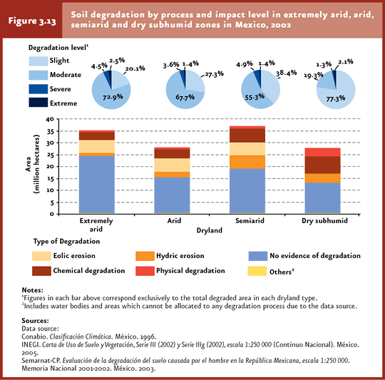
Of the country’s total drylands with signs of soil degradation, 32.4% are semiarid, 26.1% subhumid, 19.1% extremely arid and 22.4% arid areas. However, when the proportion of affected land is considered relative to the area covered by these types, dry subhumid zones turn out the most affected ones (52.8%), followed by semiarid (48.9%), arid (45%) and extremely arid areas (30.4%). As regards the distribution of degradation processes according to dry-zone type, eolic erosion appears as the dominant process in extremely arid and arid zones, whereas chemical degradation prevails in semiarid and dry subhumid areas (Figure 3.13).
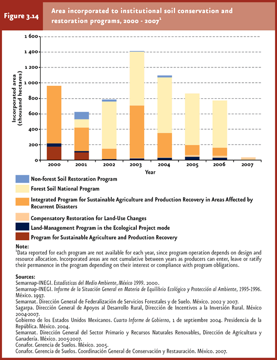
Soil conservation and restoration Historically, soil has been a natural resource virtually neglected by both government and society, despite that its degradation and desertification brings about negative consequences for the environment and population well-being. The loss of ecosystem productivity, occurrence of dust storms, loss of aquatic habitats and decrease of fisheries yields, rise in the frequency of floods and rise in greenhouse gas emissions derived from organic-matter oxidization, are just some of the environmental consequences associated with soil degradation. All of them are closely linked to the rise in poverty and migrations (Cotler et al., 2007). Due to the complexity of causes and consequences, the subjects of soil degradation and desertification are addressed by Semarnat, Sagarpa, Conaza and the National Forest Commission (Conafor). To face the soil degradation issue, the best option is to adapt a sustainable-development approach, which not only addresses current human needs but also takes into consideration the preservation of a healthy environment for the generations to come. However, putting this principle into practice is no easy task, since besides the purely environmental component there are a series of social, economic and political factors which complicate the elimination or reduction of the causes underlying soil degradation. For this reason, actions are required to promote sustainable soil management through support to rural areas, access to proper technology and support to trading activities, all of these factoring in the conditions and needs of each region and without compromising the current population’s agricultural and commercial activities. Despite the lack of an national integrated strategy for soil conservation that would define direct and specific actions for the preservation and maintenance of soil functioning within programs operated by Semarnat, Sagarpa, Conafor and Conaza, indirect actions are being implemented with technical and economic support focused on conducting hydraulic, reforestation and agriculture-land management works aimed at preserving this key natural resource. The most important institutional programs in terms of area incorporated to soil protection and restoration are the Forestal Soil Program (Programa de Suelos Forestales) coordinated by Conafor and the Integrated Program for Sustainable Agriculture and Production Recovery in Areas Affected by Recurrent Disasters (Programa Integral de Agricultura Sostenible y Reconversión Productiva en Zonas de Siniestralidad Recurrente, Piasre) led by Sagarpa (Figure 3.14). Actions considered in these programs include economic and technical assistance to land owners for the execution of forest-soil conservation and restoration works, in the former, and areas affected by recurring drought, in the latter (Cuadro D3_SUELO04_01; IB 3-4). The above programs provide support to a diverse range of projects, including the construction of dams and wind breakers or soil production recovery through agroforestry and forest-grazing systems. Given that other forest programs (e. g. sustainable forest management or reforestation) also impact soil, determining accurately the area subjected to conservation and recovery activities is a complex task (Figure 3.14; IB 3-4; Cuadro D3_SUELO04_01).
These issues are also mirrored in the insufficient reliable information that would allow assessing the performance of these programs. Given the magnitude of the issue and the insufficient resources allocated to manage it, today’s challenge consists in concentrating the supporting resources according to the soil degradation characteristics through specific actions for each degradation type and level observed. The most common conservation actions implemented address the control of runoff affecting population centers and infrastructure; however, these are hardly effective, for example, to reverse the chemical degradation issue in the fertility-loss modality, which is the prevailing degradation type in the country (16.6%), derived mostly from poor agricultural and grazing practices (refer to box Is it possible to recover degraded soil?).
Notes 6In this chapter, drylands include arid, semiarid and dry subhumid zones. Additionally, based on the terminology used by the Millenium Ecosystem Assessment in its investigation on Desertification (MEA, 2005), extremely arid or hyper-arid zones are also included. 7The classification of dryland areas into extremely arid, arid, semiarid and dry subhumid areas was done based on Köppen’s Climate Classification System adapted for Mexico (García, 1988).
|