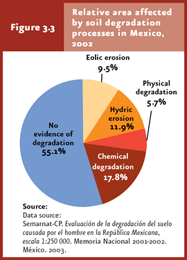
Chemical degradation is the dominant soil-degradation process in Mexico (17.8% of the country area), followed by hydric erosion (11.9%), eolic erosion (9.5%) and physical degradation (5.7%). |
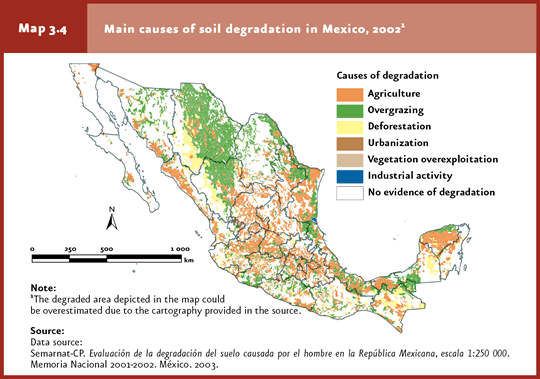
The main causes of soil degradation in Mexico are agriculture and cattle raising. |
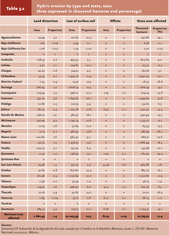
Surface soil loss is the dominant hydric erosion type in Mexico and involves a number of off-site effects, including nutrient and organic matter removal and the eutrophication of surface water bodies and aquifers. |
The dominant chemical degradation type in Mexico is the reduction in soil fertility (92.7% of the total area affected by chemical degradation in the country), which results from the decrease in the availability of soil minerals and organic matter. |
Although physical degradation is the less extended degradation process in the country, affecting only 5.7% of the national area, it involves a high impact due to its being virtually irreversible and leading to the loss of land productivity. |
| CHAPTER 3. SOIL |
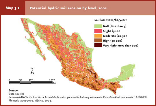
Soil degradation refers to the processes derived from human activities which lead to a reduction in either the biological productivity or biodiversity, as well as in the current and/or future capacity to sustain human life (Oldeman, 1998). Several studies have been undertaken to estimate the country’s area including degraded soil; however, the findings derived from these studies cannot be compared between one another due to methodological and scale differences (Cuadro D3_R_SUELO03_12). The two most recent studies are the Assessment of soil loss due to hydric and eolic erosion in Mexico, scale 1:1 000 000 (Semarnat-UACh, 2003) and Assessment of soil degradation caused by man in Mexico, scale 1:250 000(Semarnat-CP, 2003). The former study assesses the potential soil loss due to hydric and eolic erosion per state, based on cartography and parametric models. According to this assessment, the area with potential soil loss due to hydric erosion would amount to 42% of the country’s territory, with 17 states affected in more than 50% of their territory, including Guerrero (79.3%), Puebla (76.6%), Morelos (75.2%), Oaxaca (74.6%) and the State of Mexico (73.7%). Furthermore, the mountainous regions of the Eastern Sierra Madre, Western Sierra Madre and Southern Sierra Madre, as well as extensive regions across Chiapas and the central states, would display severe soil loss rates due to hydric erosion (Map 3.2).
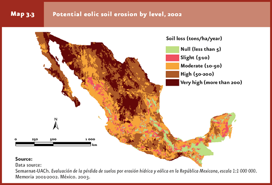
Furthermore, it was estimated that 89% of Mexico’s territory is affected by potential eolic erosion, mostly in the northern arid regions (Chihuahuan and Sonoran deserts) as well as across broad areas of Veracruz, Guerrero and Oaxaca. Several states were found to display potential eolic erosion across their whole territory: Aguascalientes, Southern Baja California, Durango, Sonora and Zacatecas, and only two states with this erosion affecting less than 30% of the area: Chiapas (29.3%) and the Federal District (21.8%; Map 3.3).
The investigation entitled Assessment of soil degradation caused by man (Evaluación de la degradación del suelo causado por el hombre en la República Mexicana, escala 1:250 000, in spanish), jointly conducted by Semarnat and the Colegio de Postgraduados (2003), is the most recent assessment of soil degradation in Mexico and involves the highest resolution to date. Four degradation processes were considered in this study: hydric and eolic erosion, and physical and chemical degradation. In turn, each process was assessed from different perspectives: causes, specific types and impact levels. To this end, the country was divided into cartographic units of different sizes; the dominant degradation or erosion was defined as the one affecting over 30% of the area in each unit. Both hydric and eolic erosion involve processes where soil material displacement occurs; chemical and physical degradation are characterized by processes that lead to in-site soil deterioration. Hydric erosion is defined as the laminar or massive removal of soil materials by water currents. As a result, the relief may be deformed and give rise to caverns and ravines. In eolic erosion, the wind acts as the soil-removal agent. Chemical degradation involves processes leading to the reduction or elimination of soil biological productivity, and is strongly linked with the expansion of agriculture. Physical degradation refers to a modification of soil structure evidenced as the loss or reduction of water-absorption and storage capacity. Based on the findings of this study, 44.9% of soils in Mexico display some type of degradation. Chemical degradation is the dominant process (17.8% of the country’s surface area), followed by hydric erosion (11.9%), eolic erosion (9.5%) and physical degradation (5.7%) (Figure 3.3; IB 3.3, IC 14)3
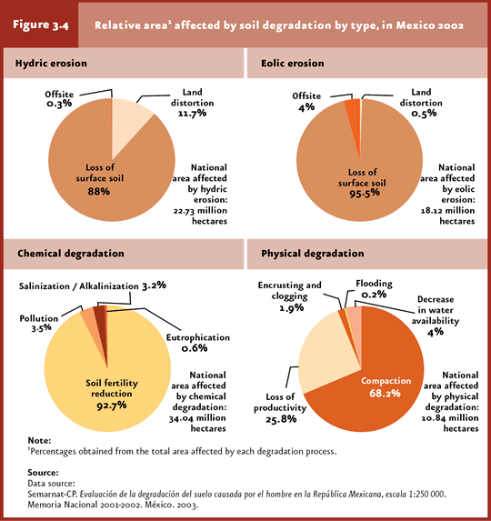
The dominant type of disturbance associated with hydric and eolic erosion is surface soil loss. Hydric and eolic erosion accounted for 88% and 95.5% of the affected country area, respectively. In the case of chemical degradation, the dominant disturbance was the reduction in soil fertility; in the case of physical degradation, it was soil compaction (92.7% and 68.2% of the affected country area, respectively; Figure 3.4; Cuadro D3_SUELO03_01).
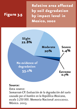
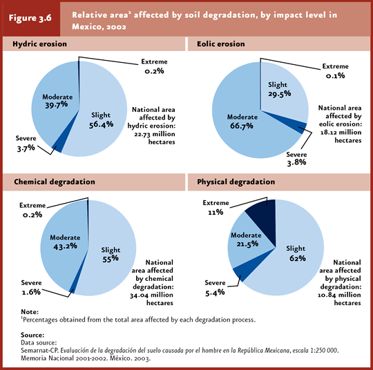
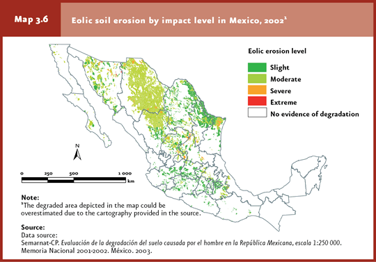
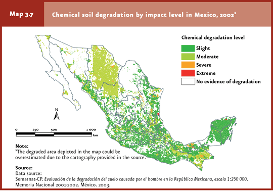
As regards the extent of degradation, 2.1% of the territory shows heavy to extreme degradation, while 42.8% shows slight to moderate degradation (Figure 3.5; Cuadro D3_SUELO03_01). If this information is analyzed in terms of the main degradation process, the vast majority of the degraded area (more than 50%) is classified as slight in the case of hydric erosion and chemical / physical degradation; in the case of eolic erosion, the affected area is deemed moderately eroded (Figure 3.6).
As to the causes of degradation, 35% of the country’s degraded area is associated with agriculture and cattle raising (17.5% each), while 7.5% is related to deforestation. The rest is split between urbanization, vegetation overexploitation and industrial activities (Map 3.4).
In Mexico, soil degradation has not taken place homogeneously (refer to Maps 3.4, 3.5, 3.6, 3.7). The degradation processes, specific types and levels differ in each state. For example, Chiapas shows virtually no signs of eolic erosion; in Chihuahua this process affected 28.5% of the area (Cuadros D3_SUELO03_01 and D3_SUELO03_03). The characteristics, levels, geographical distribution and causes of each degradation process are detailed below.
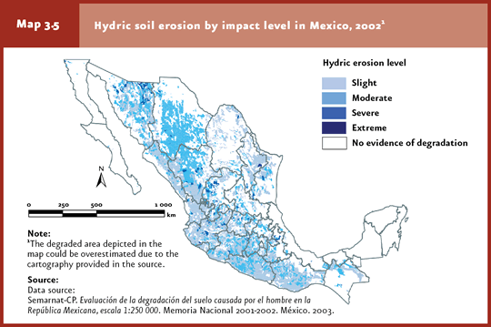
Hydric erosion Mexico is highly susceptible to hydric erosion, since nearly half of the territory (42.2%) involves slopes > 3º (INE, 2003). This topographical feature, together with poor management of forest, agriculture and cattle-raising land, promotes runoff that erodes the surface soil layers. Hydric erosion processes are dominated by the loss of surface soil. This specific degradation type involves serious consequences in the functioning of soil: removal of nutrients and organic matter, reduction of plant-root depth, and decrease of water infiltration and retention rate. Areas affected by this erosion type and dedicated to agricultural practices require the application of fertilizers, pesticides or treated water for improving productivity; occasionally, this leads to the eutrophication and contamination of aquifers or surface water bodies that receive runoff from these areas. These events are known as “off-site” hydric erosion effects. Of the national area affected by hydric erosion (22.73 million hectares), 56.4% is classified as slightly eroded, 39.7% as moderately eroded and 3.9% between heavily and extremely eroded (Figure 3.6, Map 3.5, Cuadro D3_SUELO03_03). Guerrero is the state most severely affected by hydric erosion, with 31.8% of its area (Table 3.1).
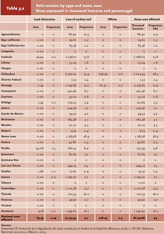
Eolic erosion Eolic erosion affects mostly, but not only, the arid, semiarid, subhumid and dry regions of Mexico. The causes of eolic erosion are also attributed to insufficient soil protection by plant cover, low humidity levels and destruction of soil structure. At a country level, 9.5% of the territory shows signs of eolic erosion. The states most affected are Chihuahua (28.5%), Tlaxcala (26%), Nuevo Leon (18.9%) and Durango (17.9%). No signs of this erosion type are evident in Campeche, Chiapas, Quintana Roo, Tabasco and Yucatan (Table 3.2). As for eolic erosion levels, 66.7% of the total affected territory (18.1 million hectares) corresponds to moderately eroded, 29.5% to slightly eroded and 3.9% to heavily and extremely eroded (Figure 3.6; Map 3.6; Cuadro D3_SUELO03_03).
The dominant eolic erosion type is the loss of surface soil, which affects 9.1% of the country territory. These sites and the surrounding land are commonly characterized by the presence of dunes, which make vegetation settlement and growth difficult. The states with the heaviest surface soil losses are Tlaxcala (26%), Chihuahua (25.9%) and Nuevo Leon (18.9%). On the other hand, off-site eolic erosion with land deformation is not widespread in the country, as it affects a little over 800 thousand hectares, that is, 0.44% of the national territory. Affected areas occur in the states of Chihuahua, Durango, Coahuila and Puebla (Table 3.2).
Off-site eolic erosion was important in the Federal District (D.F. in Spanish) and adjacent areas during the 1950s; at that time, huge dust clouds originated in the dry bed of the former Texcoco lake. This issue became aggravated when this zone was used for discharging wastewater from D.F., so that seasonal northeastern winds carried dust, organic matter particles and pathogens which led to public health issues in the Valley of Mexico metropolitan area.
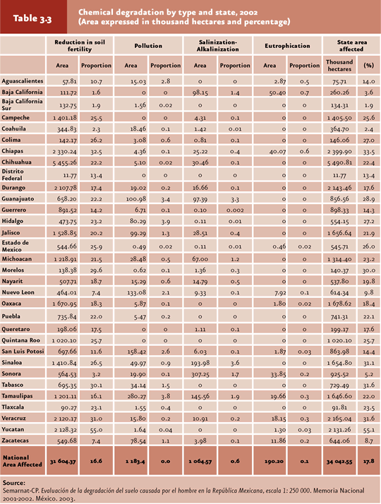
Chemical degradation Chemical degradation is the most extensive soil degradation process in Mexico (17.8% of the territory). This type of degradation occurs in all states, the most affected being Yucatan (55.1%) and the least being Baja California Sur, Coahuila, Baja California and Sonora, where the area evidencing chemical degradation represents 5.5% or less of the corresponding state territory (Table 3.3). Slight chemical degradation accounts for 55% of the national territory affected by chemical degradation; moderate, 43.2%; heavy and extreme, 1.8% (Figure 3.6; Map 3.7; Cuadro D3_SUELO03_03).
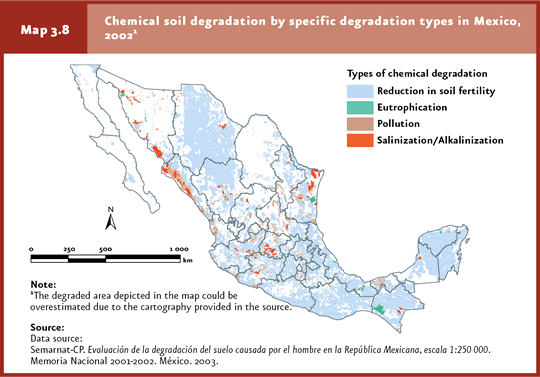
The dominant chemical degradation type was the reduction in soil fertility (92.7% of the total country area affected by chemical degradation) resulting from the decrease in the availability of soil minerals and organic matter. This degradation type occurs in more than half of Yucatan and nearly one third of Tlaxcala, Chiapas, Morelos, Tabasco and Veracruz (Table 3.3; Map 3.8). The other specific chemical degradation types (pollution4, salinization and eutrophication) are far less widespread, altogether representing 7.3% of the chemically degraded area in Mexico.
Chemical soil degradation derived from pollution is due to the presence, concentration and adverse biological effects of some chemicals. These may originate from open dumps, spills, industrial waste, deposits of acidifying substances and/or heavy metals. Salinization or alkalinization is an increase in salt content in surface soil which leads to a decline in crop yield, among other effects. This occurs mainly in arid zones, closed basins and coastal areas with naturally saline soils. Irrigation systems using high-sodium water may cause the formation of a salt-deposit layer in the surface of soils with poor drainage, excessive irrigation or heavy evaporation. Eutrophication is the presence of excessive nutrients in soil that affect plant development. Pollution, salinization and eutrophication occur mainly in Tamaulipas, San Luis Potosi, Chiapas, Nuevo Leon, Oaxaca, Veracruz and Zacatecas (Map 3.8).
The causes of chemical soil degradation involve a wide range of industrial and agricultural activities, including hydrocarbon spills, excessive fertilizer and pesticide application, poor materials management, hazardous and urban solid wastes. Fertility drops when nutrient input, either by chemical or biological fertilization or retention of crop wastes, is lower than nutrient output as crop products or resulting from burning practices and leaching.
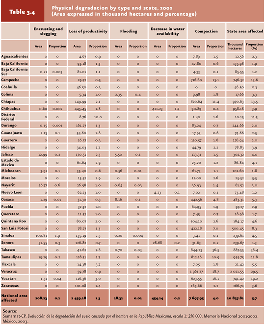
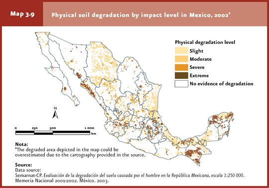
Physical degradation Physical soil degradation may occur as five different specific types: compaction, encrusting, flooding, water availability reduction and productivity loss. Compaction is the destruction of soil structure5 frequently associated with cattle trampling or the continued transit of heavy machinery, resulting in the rupture of soil aggregates. In encrusting, soil pores are filled with fine materials, preventing rainwater infiltration and leading to a rise in surface runoff and hydric erosion. Soil encrusting is higher in sparsely vegetated areas with low organic matter content, thus increasing the mechanical damage of raindrops. Flooding derives from the presence of a surface water layer upon soil, frequently associated with the construction of irrigation dams.The opposite to flooding is the decrease in water availability resulting either from excessive water extraction for use in agriculture or population supply, or from the reduction in plant cover and soil organic matter. Physical degradation is the less extended degradation process in the country, affecting only 5.7% of the national area; however, it involves a high impact due to its being virtually irreversible and leading to the loss of land productivity. Tabasco is the most severely affected state (38.4%), while Coahuila, Sonora, Queretaro, Nuevo Leon and Michoacan display limited physical degradation which affects less than 2% of their territory (Table 3.4). The most extended specific physical degradation types were compaction and productivity loss (4% and 1.3% of the total degraded area, respectively). Encrusting, flooding and water availability reduction jointly affected 0.31% of the country. The state most severely affected by compaction was Tabasco (36.5%), and the less affected states were Sonora, Sinaloa, Nuevo Leon, Coahuila, Baja California, Baja California Sur, Durango and Guanajuato, with less than 1% each. As for the loss of productivity due to non-biological activities, the Federal District was the most affected state (10%); the less affected states (with less than 1% of area affected) were Campeche, Coahuila, Guerrero, Michoacan, Oaxaca and Sonora. The other three specific physical degradation types affected some 2% of the territory in several states across the country (Table 3.4).
As for degradation levels, extreme physical degradation encompassed 1.2 million hectares; strong degradation, 587 thousand hectares; moderate, 2.3 million; slight, 6.7 million hectares (Figure 3.6; Map 3.9, Cuadro D3_SUELO03_03).
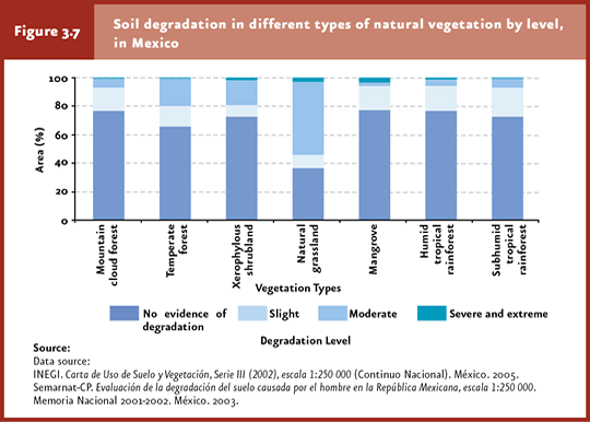
Relationship between soil degradation and plant cover Soil degrades as a result of a number of environmental and socioeconomic factors including topography, climate, production and land-owning systems, public policies and market. Soil degradation and vegetation cover loss are rarely triggered by a single factor, although the ultimate factors in nearly every case are human activities through changes in soil use, replacing natural vegetation by land dedicated to agriculture and cattle raising. Despite no specific studies have been conducted to date to assess the relationship between soil degradation and vegetation cover in Mexico, the combination of the most recent national degradation (Semarnat-CP, 2003) and land-use and vegetation charts (INEGI, Serie III) provide a good approximation of its status in Mexico. According to this exercise, soil degradation was detected even in areas covered by natural vegetation. In subhumid and humid tropical rainforests, and in temperate and cloudy forests, the dominant degradation level is slight, whereas it is moderate in dry shrubland. Heavy and extreme soil degradation occurs in natural grasslands used for cattle grazing, and in mangrove forests used for water-related activities and road infrastructure, among others (Figure 3.7).
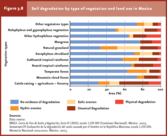
A key factor in the soil-vegetation relationship lies in the level and type of soil degradation in crops, cattle-raising areas and cultivated forests. Around 70% of the national area devoted to these activities (some 34.5 million hectares) is affected by some type of degradation, with chemical degradation being the dominant type under the quality-loss modality. This soil degradation may be explained in terms of the change in land use in areas unsuitable for agriculture (Figure 3.8). Within the natural vegetation types, temperate forest soils are the ones most severely affected by hydric erosion, likely because many of them are found in mountainous areas, where the slope aggravates the effect of runoff. Xerophylous shrubland, grasslands and halophylous and gypsophylous vegetation are the vegetation types were eolic erosion constitutes the dominant process, whereas humid and subhumid forests display a high degree of chemical degradation. When the area of the country that these ecosystems comprise is taken into account, xerophylous shrubland and temperate forests involve the highest percent of degraded area (32.6% and 41.2%, respectively), equivalent to 14.8 and 11.8 million hectares affected, respectively (Figure 3.8; Cuadros D3_SUELO03_02 y D3_SUELO03_06; IB 3.3, IC 14).
Note
|