The instruments aimed at preserving the country’s terrestrial ecosystems – ANPs, Ramsar wetlands and PSAs – comprised nearly 22.2 million hectares as of December 2008, that is, 11.3% of the national terrestrial area. |
As of December 2008, federal terrestrial ANPs protected 18.7 million hectares, mostly including xerophilous shrublands, temperate forests and evergreen and semi-deciduous tropical rainforests. |
In 2008, the continental Ramsar wetlands protected 3.15 million hectares, of which 1.45 million were included within ANPs and 1.7 million were not. |
As of December 2008, the Pay-Per-Environmental-Services Programs comprised nearly 1.8 million hectares, protecting mostly temperate, mountain cloud and tropical forests. |
The instruments aiming to achieve sustainable use of natural resources from the country’s terrestrial ecosystems – Uma, Prodefor and Procymaf – comprised, as of December 2008, nearly 49.5 million hectares, equivalent to 25.2% of the country’s terrestrial area. |
As of December 2008, Umas comprised some 30.9 million hectares, concentrated in northern Mexico and comprising xerophilous shrublands, grasslands and temperate forests. |
Prodefor covered, by December 2008, nearly 18.1 million hectares, including mostly xerophilous shrublands, temperate and tropical forests. |
The instruments for the recovery of the country’s national ecosystems – Procoref, through reforestation, forest-soil conservation and restoration and forest-health measures, and Prodeplan - served nearly 4.2 million hectares by December 2008, that is, 2.2% of the country’s terrestrial area. |
Between 1993 and 2008, around 2.9 million hectares have been reforested in the country, with Coahuila, San Luis Potosi, Chiapas and Veracruz being the states with the largest reforested area in this period. |
Between 2003 and 2007, the country’s treated area to fight forest pests and diseases was around 58% of the affected area. |
Between 1997 and 2008, Prodeplan has supported commercial forest plantations in more than 650 thousand hectares, covering all the states of the country. |
Today, 19.9% of Mexico’s terrestrial area (that is, 38.99 million hectares) has decreed ecological land-use plans and 34.7% (67.87 million hectares) has land-use plans under elaboration. |
| CHAPTER 2. TERRESTRIAL ECOSYSTEMS |
The magnitude of the historical transformation and loss of natural ecosystems, as well as the application of non-sustainable exploitation schemes over decades, has inevitably led to the environmental degradation throughout the whole territory. Although these are ultimately the most important forces in terms of their effects on natural vegetation, these are not the only ones. Other activities, such as those leading to air, soil and water pollution have also exerted an impact, sometimes significant, on the condition of the country’s natural ecosystems. The environmental consequences of the clearance and degradation of the plant cover are clearly evident in Mexico: these range from landscape deterioration itself to degradation of soils and their productive role, loss of biodiversity, reduction in the availability of surface water and groundwater, and the scarcity and low production of many products directly or indirectly derived from the natural resources supplied by ecosystems. Likewise, the vulnerability of many regions to extreme meteorological events, including floods and hurricanes, is partly due to the deterioration and loss of natural ecosystems. However, the consequences of the deterioration are not restricted just to the environmental arena, but, given the strong dependence between population and environment, these transcend and affect population welfare (refer to the section Human activities and environment in the Population chapter). Environmental degradation is usually paralleled in the short-, mid- and long term by the loss and deterioration of the subsistence means and living standard of many communities – specially in rural areas -, which may lead to a worsening of the marginality and poverty conditions, which in turn may fuel negative social phenomena that affect society as a whole. In this sense, it is evident that social development has depended – and will likely continue doing so – on the continued and proper supply of environmental services by ecosystems, which is inevitably linked to the latter’s integrity and functioning. This panorama evidences the need to implement, under the federal government’s leadership, all strategies required to guarantee the permanence of the country’s natural capital available as natural ecosystems and the continued supply of the environmental services they provide. In general, the federal programs and actions proposed to achieve these goals can be categorized into three lines. First, there are instruments seeking to protect and stop the loss of Mexico’s remaining natural ecosystems, which, besides guarding ecosystems and species representative of the country’s biodiversity, preserve key environmental services for the country. These basically include the protected natural areas, the wetlands included in the Ramsar Convention and the pay-per-environmental-service programs. The second line concentrates all programs that aim to improve the population’s living standard through encouraging the exploitation of natural resources available for communities – mainly forest resources -, in an effort to make sure that this exploitation does not exceed the resources’ recovery capacity to keep levels allowing long-term extraction. This line includes wildlife-use and forest-development programs. A key step for the advance and consolidation of this line has been the launch of the ProÁrbol initiative in February 2007. This program aims at contributing to fight poverty by recovering forest resources and improving productivity in the country’s temperate and tropical forests. Efforts are also focused on the conservation of forest areas, which include the pay-per-environmental-service programs mentioned above. For further details on this program, its specific objectives and strategies, refer to the Box ProArbol: conservation, recovery and sustainable use of terrestrial ecosystems in Mexico. The following sections also include some outcomes of the various activities conducted across the programs’ initiatives. Last, yet another key aspect of the efforts done has involved actions attempting, on the one hand, to reverse the loss of natural vegetation, basically through reforestation; on the other, to stop the threat of wildfires, diseases and pests. It is worth mentioning that there are other instruments that have also been indirectly useful to protect the country’s terrestrial ecosystems: ecologically-based land-use planning and environmental impact assessments. The former serves as an ecological planning tool seeking a balance between productive activities and nature conservation through the harmonization of land-use potential, priorities and needs. For their part, environmental impact assessments aim at identifying and quantifying the potential environmental impacts derived from the execution of projects, hence determining the project’s environmental feasibility and proper conditions for execution, as well as environmental impact prevention and mitigation measures
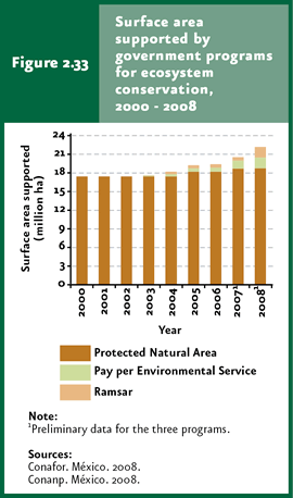
Conservation of terrestrial ecosystems and environmental services In the case of terrestrial ecosystems, the conservation strategy essentially aims at warranting the protection of natural areas with negligible or nil human influence and perturbation, which are important because of their biodiversity and/or the environmental services supplied to society. Within this strategy, the most important instruments implemented so far are protected natural areas (ANPs in Spanish), Ramsar Convention wetlands and the pay-per-environmental-service programs (PSAs in Spanish). Altogether, these instruments protected around 22.2 million hectares4 as of December 2008, equivalent to 11.3% of the country’s continental surface, approximately (Figure 2.33).
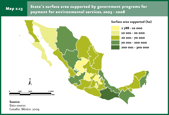
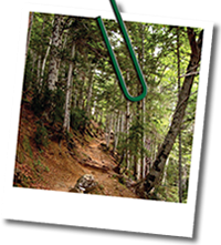
Protected natural areas represent one of the strategies most frequently used worldwide to preserve the ecosystems’ integrity. These areas are representative of various ecosystems, where the original environment has not been significantly altered by human activities, which additionally supply several types of environmental services, and which may even include relevant natural resources or important species from ecological, economical and/or cultural standpoints. In Mexico, the increase in the area of terrestrial ecosystems protected by federal ANPs has been significant: it went from 15.5 million to 18.7 million hectares between 1994 and 2008, accounting for about 9.5% of the country’s continental area in 2008 (Cuadro D3 BIODIV04_12; IB 6.1-6). To note, protected terrestrial ecosystems within ANPs in 2008 represent 80.6% of the total area included in this instrument, and the remaining 19.4% (4.5 million hectares) corresponds to marine areas (refer to the Biodiversity chapter for further details). Among the federal terrestrial ANPs, the ecosystems with the greatest representation are xerophilous shrublands (nearly 6.8 million hectares, 37.7% of the protected terrestrial area), temperate forests (3.3 million hectares, 18.5%) and evergreen and semi-deciduous tropical rainforests (3.1 million hectares in all, 8.8 and 8.2%, respectively). For further information on this instruments, refer to the Biodiversity chapter, section Biodiversity protection. Importantly, together with the development of federal ANPs, state, community, collective and private protected areas have also been created, all of which increase the country’s area of protected terrestrial ecosystems. Furthermore, Mexico also participates in the international wetlands protection trend led by the Ramsar Convention, subscribed by Mexico in 1986, which seeks to preserve and promote the rational use of wetlands, especially those internationally important in ecological, botanical, zoological, limnological or hydrological terms. By December 2008, Mexico had registered 112 sites to the Convention, comprising about 8.5 million hectares. The country’s continental territory includes 94 Ramsar wetlands, covering an area of 3.15 million hectares approximately, which protect mangroves, swamps, lagoons and river mouths, among other ecosystems. Of these, 46 are totally of partially included within ANPs – covering an area of 1.45 million hectares - while the remaining 48 are not (with an area of nearly 1.7 million hectares). For further details on Ramsar wetlands, refer to the Water chapter. The recent acknowledgement about the importance of the ecosystems’ environmental services have led to the design of a set of strategies aimed, in general terms, at achieving that those who receive environmental services pay for them to the suppliers, that is, the owners of land covered by the ecosystems supplying these services. This strategy intends to change, in practice, the old conception of environmental services as “free-of-charge” gifts from ecosystems, in an attempt to foster their protection and prevent changes in land use. Mostly, these strategies have been directed, in Mexico and worldwide, to protecting basins, preserving forests and biodiversity and capturing carbon. Mexico’s first step in this respect was the start-up of the Pay-Per-Hydrological Environmental Services (PSAH in Spanish) in 2003, coordinated by the National Forest Commission (Conafor) and which is included, from this presidential term, in the ProÁrbol program. The main PSAH’s objective has been the preservation of hydrological environmental services supplied by temperate and tropical forests, through an economic fee paid to forest-land owners providing these services, who are obliged to maintain their land in good condition – with no land-use changes – during the period set forth in the agreement. Support has been focused on critical basins with overexploited water resources, or which supply water to towns with more than 5 thousand inhabitants. The Program to Develop the Environmental Services Market for Carbon Capture and Those Derived from Biodiversity and to Promote the Establishment and Improvement of Agroforestal Systems (PSA-CABSA in Spanish) was the second initiative of its kind and came into effect in the year 2004. It promotes access of forest land owners to national and international environmental services markets related to carbon capture and forest ecosystems’ biodiversity. In this case, fees are paid to encourage owners to implement actions oriented to maintaining or improving the supply of certain environmental services (climatic change mitigation, biodiversity preservation). In all, the areas benefitted by the pay-per-environmental-services programs (PSAH and PSA-CABSA) – mostly temperate, mountain cloud and tropical forests - reached, nearly 1.8 million hectares according to preliminary figures for December 2008, 1.5 million of which (84% of the combined area of both programs) belong to PSAH and the remaining 280 thousand hectares (16%) to PSA-CABSA. Map 2.13 shows the areas supported by the environmental services programs between 2003 and 2008 by state.
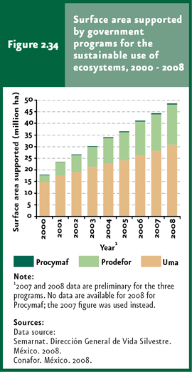
Sustainable use of natural resources from terrestrial ecosystems In Mexico and worldwide, natural resources were perceived for a long time as endless sources of sustenance and economic income. Thus, their use, in many cases, was driven solely by market demand and everyday needs, neglecting the capacity to recover the natural environmental variability and the exploitation rates. Consequently, the populations of many species were drastically reduced, even to the extent of local extinctions, which led to the collapse in their production or, in extreme cases, their definitive commercial extinction. Commercial exploitation is not the only factor leading to an unsustainable extraction of natural resources: even some traditional extraction practices may lead to the deterioration of wildlife populations, so that these also warrant specific regulations making possible the good use of natural resources in the long term. In order to achieve the sustainable use of the country’s wildlife, a number of instruments have been designed and implemented, which can be grouped into two main axes: wildlife management that does not necessarily involves species of forest importance but others of hunting or decorative interest, for example – represented by the System of Management Units for Wildlife Conservation (Suma) -; secondly, the development of forestal activities through the rise in productivity and the diversification in the use of forest ecosystems, integrated by the Forest Development Program (Prodefor in Spanish) and the Communitary Forest Development Program (Procymaf in Spanish). As a core objective, both axes also aim at improving the living standard of land owners of exploited natural ecosystems. Altogether, until December 2008 these programs have supported a total area of almost 49.5 million hectares (Figure 2.34), equivalent to 25.2% of the country’s continental land. Of the area benefitted by 2008, 62.4% belonged to Uma (some 30.9 million hectares), 36.6% to Prodefor (18.1 million hectares) and the remaining 0.9% (nearly 468 thousand hectares) to Procymaf.
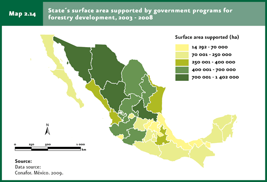
The System of Management Units for Wildlife Conservation (Suma) was created in 1997 and is coordinated by Semarnat through the General Wildlife Direction (DGVS). It seeks to make a legal and feasible use of wildlife while promoting alternative and environmentally-friendly production schemes through the rational, planned and scheduled use of natural resources. Besides allowing the sustainable use of wildlife populations and producing economic income to owners of land where these units are established, this instrument preserves, as a side effect, the habitat of target species – needed to maintain exploited populations in good conditions -, as well as the environmental services they supply. To date, Uma are concentrated in northern Mexico, with xerophilous shrublands, grasslands and temperate forests (in that order) as the main ecosystems benefitted from this instrument. In some cases, Umas have been established within ANPs, leading to additional benefits, including a lowering of the pressure exerted on communities in protected areas, preservation of habitats where the species of interest live and a better knowledge of species, habitats and ecosystems. Although no recent data on the area of Umas included in ANPs is available, in 2005 it amounted to nearly 2.5 million hectares, that is, a little over 10% of the total area covered by Umas that year. For further information on Umas, please refer to the Biodiversity chapter, section Biodiversity protection. Before detailing the instruments established to foster sustainable forest development in Mexico, it is worth mentioning that a key step for the development of these instruments was the creation of Conafor in 2001. Its mission has been to develop a policy for attaining sustainable forest development based on the participation of both society and the government. In turn, Conafor’s creation led to the elaboration of a new General Law for Sustainable Forest Development (approved in February 2003), aiming to contribute to the country’s social, economic, ecological and environmental development; promoting silviculture and the good use of forest resources; developing environmental goods and services and protecting forest biodiversity, respecting in all cases the right of indigenous communities to use and enjoy these resources. The Forest Development Program (Prodefor), which started in 1997 coordinated by Conafor as part of ProÁrbol, aims at promoting the productivity and diversification in the use of forest ecosystems, as well as developing the forest production chain, through the provision of economic support to owners of exploited forest land, including “ejidos”, communities and small landowners. This program is coordinated jointly with state governments. Prodefor has grown significantly since its creation: it went from 3 million hectares supported in the period 1997-2000 to 18.1 million hectares in 2008 – according to preliminary data for this year -, which represents a mean annual rise of 1.4 million hectares. The main ecosystems benefitted have been xerophilous shrublands – basically because of the richness in non-timber products -, temperate and tropical rainforests. The area supported by this Program by state between 2003 and 2008 is shown in Map 2.14.
For its part, the Program for Communitary Forest Development (Procymaf II) seeks that “ejidos” and mostly indigenous communities located in priority regions in the states of Durango, Guerrero, Jalisco, Michoacan, Oaxaca, Quintana Roo, Chiapas, Chihuahua, Campeche, Puebla, Veracruz and Mexico establish sustainable forest management practices under communal forestry schemes which result in local development processes. In its first phase (Procymaf I), which started in 1998 and ended in 2003, this program benefitted nearly 272 thousand hectares, to which another 196 thousand have been added to the year 2007.
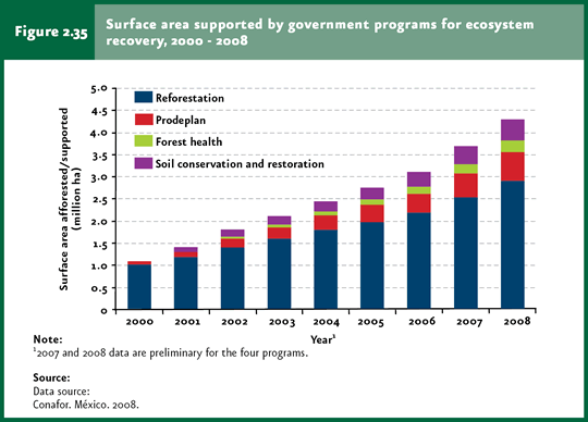
Recovery of terrestrial ecosystems Since a while ago, the significant loss and alteration of the country’s natural ecosystems triggered the design and implementation of environmental policy instruments oriented not only to protecting the remaining ecosystems and achieving sustainable use of wildlife – including forestry -, but also the recovery of areas affected by pests or diseases, degraded zones or those where natural ecosystems have already disappeared, when feasible. The major strategies along this line have traditionally been reforestation, the promotion of forest plantation, fight of forest fires and forest-health practices. Even when it is known that some of these strategies – reforestation, for instance – cannot restore ecosystems to their original condition, that is, with their biodiversity and ecological processes functioning as they did before human intervention, it is well known that these do contribute to prevent environmental degradation and keep certain basic environmental services, including groundwater recharge and the conservation of soil productivity, for example. Some other measures, such as those implemented to fight forest fires, pests and diseases, prevent a further loss and alteration of ecosystems as well as the propagation of the underlying causes –fire, pests and diseases, respectively -, which may further affect broad areas of natural vegetation. The terrestrial ecosystems’ recovery programs implemented in Mexico include the Forest Ecosystems Conservation and Restoration Program (Procoref in Spanish, which includes efforts from the Reforestation Program, forest soil conservation and restoration measures, as well as forest health initiatives) and the Program for Commercial Forest Plantations (Prodeplan in Spanish), both under the ProÁrbol program coordinated by Conafor. The accumulated area under the care of these two programs as of December 2008, according to preliminary data, rose to 4.2 million hectares, 68.8% of which corresponded to reforestation efforts (nearly 2.9 million hectares), 6.1% to forest-health activities (258 thousand hectares, approx.), 10.9% to forest-soil conservation and restoration (nearly 461 thousand hectares) and 14.3% to forest plantations (around 650 thousand hectares; Figure 2.35). In all, the area served by these instruments until 2008 represented about 2.2% of the country’s terrestrial area.
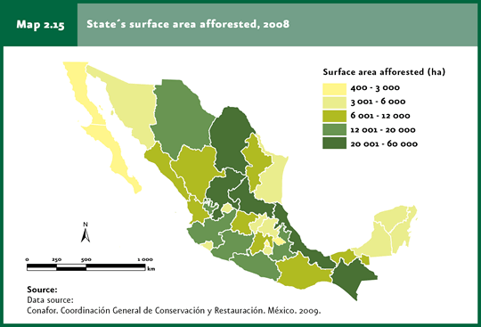
A strategy adopted by the federal government to prevent and reverse the deterioration of Mexico’s forests has been reforestation. Although reforestation has been carried out in Mexico since a long time ago, these efforts failed to display the expected results. The reasons behind this inefficiency include: i) insufficient information and application of non-environmental criteria for planting trees; ii) selection of species unsuitable for the areas to be reforested; and iii) lack of follow-up to tree plantations, leading to the death of a large proportion of planted trees. Regardless of the cause, the final outcome was that the reforestation programs made a minor contribution to the recovery of the forest cover in Mexico. The National Reforestation Program (Pronare) was created in 1995 aimed at solving the problems mentioned above through proper reforestation in strategic areas. This program was transferred to Conafor in 2001, and today is incorporated to Procoref as a Reforestation Program. Currently, reforestation works are carried out mainly in disturbed forest areas, mostly those affected by fires, subjected to illegal clearing, overgrazing and those susceptible to reconversion into forest land; a portion of reforestation is also conducted in ANPs. The Program is using native species suitable for each ecosystem. In the case of tropical species, the red cedar, mahogany, “palo de rosa” and ”primavera” are the species of choice, while conifer trees, mainly pine trees, are chosen for temperate areas. For semiarid regions, agave plants5, prickly-pear cacti, acacia trees, “sotol” and “piñonero” pine trees are produced. In Mexico, the reforested area has followed a rising trend since the beginning of the 1980s to date: while in 1993 nearly 42 thousand hectares were reforested in the country, by 2008 these reached 373 thousand hectares. This same year, the states with the largest reforested areas were Coahuila (59 thousand 253 hectares), Chiapas (41 thousand 479 hectares), San Luis Potosi (35 thousand hectares) and Veracruz 31 thousand 403 hectares; Map 2.15). By contrast, the states with the smallest area of reforested land were the Federal District (a little over 400 hectares) and Baja California Sur (587 hectares).
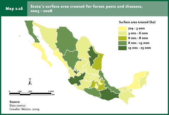
Forest pests and diseases may cause serious effects to ecosystems and, consequently, to rural communities dedicated to forestry. Forest-health practices carried out within Procoref are basically focused on the prevention and fight of forest pests and diseases with potential ecological, economic and social impact. These actions include, first of all, a phytosanitary diagnosis, mainly in areas covered by natural vegetation, as well as in forest plantations, tree nurseries, reforested areas and urban zones. Once the diagnosis has been obtained, a treatment is applied, as required. Between 2003 and 2008, the average treated area at a national level exceeded 38 thousand hectares. The states with the largest treated area in that period were Nuevo Leon (a little less than 23 thousand hectares), Oaxaca (a little over 22 thousand hectares) and Jalisco (20 thousand hectares), while the states with the smallest treated areas were Morelos (a little over 700 hectares), Baja California Sur (one thousand 400 hectares) and Tlaxcala (around 2 thousand hectares, Map 2.16).
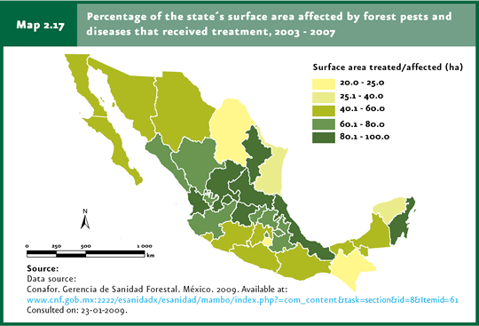
The country’s efforts to treat areas affected by forest pests or diseases are still insufficient, since of the affected area in 2003-2007, treatment activities were possible in less than 58% of the affected area. The states treating the largest percentage of affected land were Aguascalientes and Guanajuato (both treating the total affected area) and Nayarit and San Luis Potosi (both treating a little more than 98%). By contrast, the states that treated the lowest proportion of affected land were Chiapas (around 23%), Morelos (less than 24%) and Coahuila (about 24%; Map 2.17).
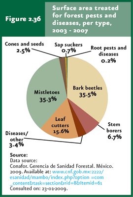
Based on the surface treated, the most intensively treated pests in the period 2003-2007 were bark insects, with 64 thousand 300 hectares (equivalent to 35.5% of the area treated in this period), followed closely by mistletoe (64 thousand 100 hectares; 35.3%) and defoliators (28 thousand 289 hectares,15.6%; Figure 2.36).
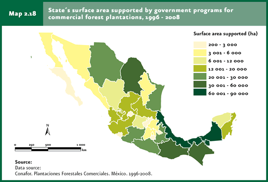
The pressure exerted on forest ecosystems for timber and non-timber extraction contribute to reduce forest quality, shifting from primary forests with their biodiversity and environmental services under the normal conditions to secondary forests, relatively impoverished in species. One option for reducing the stress on the country’s plant communities is the establishment of managed systems from which the products obtained from natural vegetation could be extracted in an easy and profitable way. In 1997 the Program for the Development of Commercial Forest Plantations (Prodeplan in Spanish) was launched, aimed at supporting the establishment (in non-forest land) and maintenance of commercial plantations to attain self-sufficiency in forest productions. This program has yielded noticeable results over the past years: from 1998 to 2008 support has been provided to plantations comprising a little over 650 thousand hectares and covering all the states of the country. The states with the largest forest plantations supported by this program are: Campeche (a little more than 84 thousand hectares), Veracruz (about 77 thousand hectares), Tabasco (60 thousand hectares) and Oaxaca (nearly 54 thousand 500 hectares; Map 2.18).
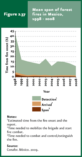
Another strategy to prevent the destruction of the country’s plant cover is fighting forest fires. The actions involved in this strategy include prevention, forecast and direct fight. Prevention practices include fire-breaking gaps and prescribed burns, environmental education and legal actions. The National Meteorological Service provides support as to wildfire forecasts, with information on droughts and high temperatures. Mexico’s Forest Fire Information System is administered through an agreement with the Ministry of Natural Resources of Canada. This System calculates a wildfire-risk index based on meteorological data, the amount of fuel materials and topography, among others. This information is used to produce a cartographical representation highlighting the spots where the most severe wildfires may occur. The detection of current wildfires takes place through visual detection from towers, planes or land vehicles. The University of Colima and Conabio conduct a permanent satellite monitoring of “hot spots”, i.e. areas where wildfires could occur. All this enables to arrive as soon as possible to affected sites to fight wildfires. Leaving the year 1998 aside, when a large amount of wildfires were recorded – which limited the effectiveness of actions taken -, this program has made possible to reduce the average duration of wildfires (Figure 2.37).
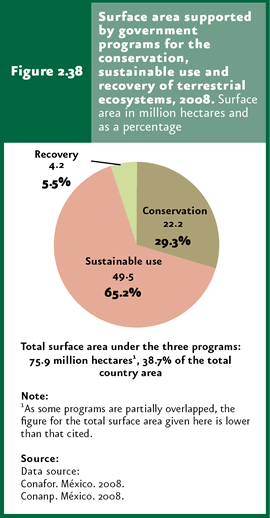
In summary, it can be affirmed that, until December 2008, the instruments included in the three lines mentioned above – ecosystem conservation, sustainable use and recovery – may have served, altogether, a total area of nearly 75.9 million hectares, equivalent to 38.7% of the country’s continental territory (Figure 2.38). Nevertheless, it is worth stressing that, since some instruments have overlapped areas – Umas and PSAs with ANPs or reforested areas within ANPs, for example -, the area served may be considerably smaller.
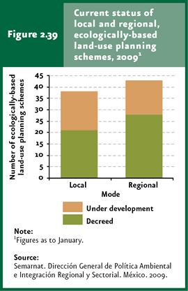
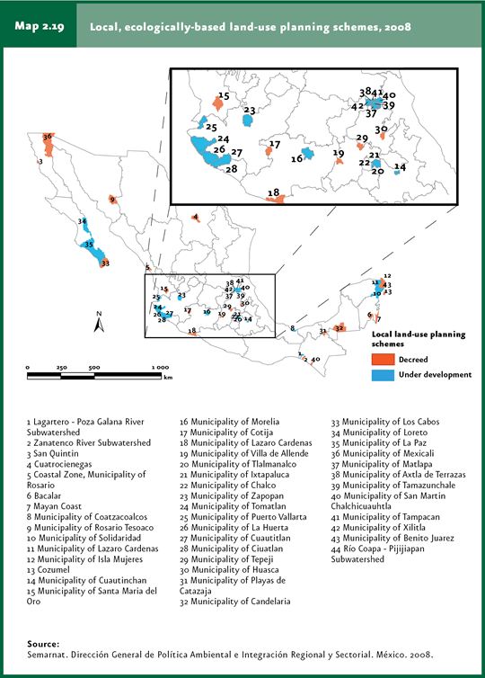
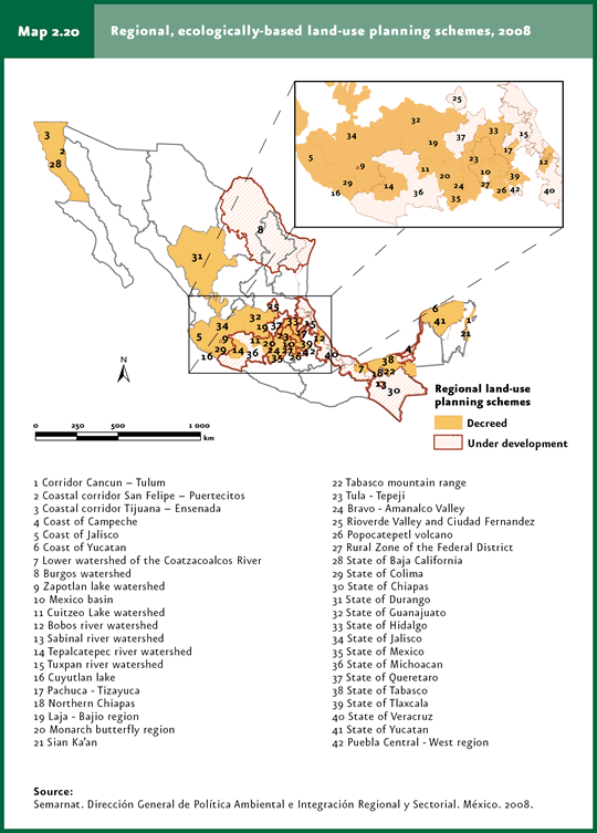
Other indirect terrestrial ecosystem protection instruments Since the settlement of the earliest human communities, land use was driven mostly by man’s need for food, housing and traditions, which transformed many ecosystems to cultivated land, cattle-raising areas and urban zones, among other uses. The environmental consequences of these changes, in addition to the loss of plant cover, biodiversity and environmental services, often brought about negative economic and social consequences for many human communities. The settlement of human populations in high-risk areas, forest clearing in mountainous areas for farming practices and the elimination of mangroves to develop aquaculture farms are some examples of decisions which, taken with no knowledge on land suitability, have led to environmental and social issues far in excess of the benefits obtained by communities from implementing them. The decision on how to use a piece of land should be based, at list partially, on an “analysis of suitability” that is, a procedure which, from the environmental features of the study area, allow to select among land-use options, including productive activities, sustainable use of natural resources, maintenance of environmental services and goods and conservation of ecosystems and biodiversity. Although this decision is influenced by economic, social or historical criteria, a territory’s natural attributes should play a key role in the definition of the limits for developing productive activities. The territory’s ecological land-use planning, which is legally defined as ”the environmental policy instrument aimed at regulating or inducing land use and productive activities to attain environmental protection, the conservation and sustainable use of natural resources from the trend analysis of deterioration and their potential use” (General Law of Ecological Balance and Environmental Protection, Title First, Article 3, fraction XXIII), is used to reconcile the land-use suitability, priorities and needs. From the publication of the Directive of the General Law of Ecological Balance and Environmental Protection (LGEEPA in Spanish) in matters of Territory Ecological Land-Use Planning (OET in Spanish), the former OET vision was replaced by one of an ecological land-use planning instrument seeking to attain a balance between productive activities and nature conservation. OET is conceived as a process through which the different sectors within the territory expand on their needs and interests (both current and for the future); and seek, through the negotiation and reconciliation of interests, the land-use option that minimizes the conflicts between the various activities, by subscribing an agreement of commitments to adopt it and abide by its terms. According to LGEEPA, there are four modalities of ecological land-use planning programs. The first is the overall ecological land-use planning, of an indicative nature for the private sector but mandatory for the federal government, which encompasses the whole territory; the second is regional land-use planning, applicable to two or more states, two or more municipalities or the whole state; the third is local land-use planning, applicable to a whole or part of a municipality and, last, ecological marine land-use planning, which includes marine areas and adjacent federal zones (refer to the Box Ecological marine land-use planning). As regards the advances in the layout of the Territory’s General Program of Ecological Land-Use Planning, a multidisciplinary task force was chartered in April 2008 to elaborate this program; this included representatives from the Boards of the Environment and Natural Resources (Semarnat); Social Development (Sedesol); Agriculture, Cattle-Raising, Rural Development, Fisheries and Feeding (Sagarpa); Communications and Transportation (SCT); Tourism (Sectur); Energy (Sener); Agricultural Reform (SRA); Domestic Affairs (Segob) and National Institute of Statistics and Geography (INEGI). In 2008, the technical assessment to identify priority areas for each sector was completed, and the environmental suitability for developing the different productive activities in the national territory was defined. This strategy seeks to promote the development of sectors in those areas with the highest potential and having the characteristics to minimize environmental impacts and conflicts. Separately, as of January 2009 38 local land-use plans were registered, 21 of which were already decreed and 17 were under way. By this same date, 43 regional land-use plans were issued, 28 of which were decreed and 15 were under way (Figure 2.39). Today, 19.9% of the country’s terrestrial area (that is, 38.99 million hectares) has decreed land-use plans and 34.7% (67.87 million hectares) have plans under elaboration. Most of the decreed ecological land-use planning initiatives are located in the Baja California and Yucatan peninsulas, as well as in central Mexico, and many of them involve the participation of the urban development and tourism sectors (Maps 2.19 and 2.20). In the case of both peninsulas, ecological land-use planning seeks environmental conservation so that these areas remain attractive for tourism, one of the most important sources of income in both regions. This does not preclude the existence of additional oriented to ecological conservation with the participation of the farming, fishing and forestal sectors.
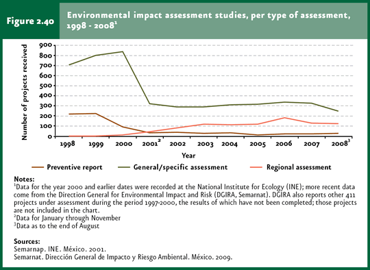
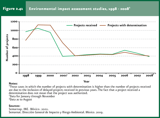
Environmental impact assessment Environmental impact is defined as any modification of the environment caused by man or nature. However, only modifications caused by human activities are assessed by the Mexican government. In this sense, environmental impact assessment (EIA in Spanish) is an environmental policy instrument seeking a detailed analysis of various development projects and the site where these are to be conducted, with the purpose of identifying and quantifying any environmental impacts derived from its execution. This assessment makes possible to determine the environmental feasibility of any project (through the environmental cost-benefit analysis) and determine – as required – the conditions for its execution and the environmental impact prevention and mitigation measures, in order to prevent or minimize any negative effects on the environment and human health. The environmental impact assessment process in Mexico started in 1988 with the publication of the LGEEPA and its Directive in Environmental Impact Matters in the Federation Official Gazette. The Directive set forth three modalities for submitting the Environmental Impact Assessment Statement: general, intermediate and specific. Likewise, the types of projects that should be subjected to the environmental impact assessment process were defined, along with a detailed description of the format in which the information should be submitted. The modifications to the Directive on Environmental Impact Matters were published on May 30, 2000, and came into force on June 29 of the same year. The most important changes include the redefinition of operations and activities subjected to the environmental impact assessment process at a federal level, which are classified according to the type of activity, industry or natural resources likely to be affected. In this regard, it was determined that the states and municipalities are responsible for the environmental impact assessment of those operations and activities not included in the list under the federal government’s responsibility. Additional key modifications included the change from general, intermediate and specific to particular and regional modalities. In general terms, environmental impact assessment statements must be submitted under the regional modality in the case of projects including industrial parks, aquaculture farms covering more than 500 hectares, highways, railroads, nuclear-energy generation projects, dams and, in general, projects affecting hydrological basins. This assessment modality is also needed in the case of works to be developed in areas with an ecological land-use plan in place or in areas where cumulative, synergistic or residual impacts can be foreseen which may lead to ecosystem destruction, isolation or fragmentation. In all other cases, the statement must be submitted under the respective particular modality. It is worth stressing that if a project contemplates activities regarded as involving a high risk, the environmental study must attach a risk-assessment study for review and ruling. In order to submit a project and get approval, the applicant (that is, the person or organization promoting the project) shall submit to Semarnat a Preventive Report or an Environmental Impact Assessment Statement according to the respective modality and as per the Directive issued by the state where the project is to be developed. Figure 2.40 shows the projects submitted for environmental impact assessment by modality during the period 1998-2008 (Cuadro D4_IMPACTO00_02).
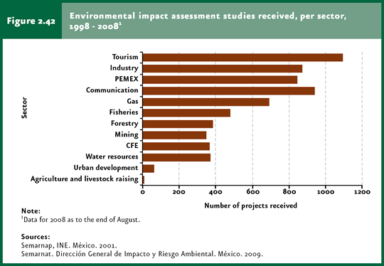
Once the environmental impact Assessment Statement has been assessed, Semarnat issues the corresponding resolution through which it may either deny or approve the authorizaiton for the project’s execution. In case of an approval, this may be granted according to the terms requested or, if deemed necessary, stating the additional conditions or prevention/mitigation measures to be met. An approval request may be denied when the applicable regulations are not met, when one or more species are jeopardized or threatened of extinction as a result of the project’s execution or when the information provided by the applicant is false. The LGEEPA’s Directive in Matters of Environmental Impact Assessment specifies the deadlines for Semarnat to assess the study after submission and issue a resolution through the Undersecretary of Environmental Protection Management. Since 1998, Semarnat has received a considerable amount of statements, which dropped significantly since 2000 from more than one thousand projects in 1999 to 392 in the year 2008 (Figure 2.40). To note, this decrease can be partly explained by the fact that, in May 2000, the processing of projects previously assessed in the Board’s central offices were transferred to Semarnat’s Federal Delegations. In the period 1998-2008, Semarnat received 5 thousand 793 projects (averaging 579 per year) and processed 6 thousand 111 environmental impact assessment statements (Figure 2.41). Most of them dealt with projects related to works and services belonging to tourism (1 097 projects), industry (874), petrochemical industry (Pemex; 849), communication roads (940) and the gas industry (691).
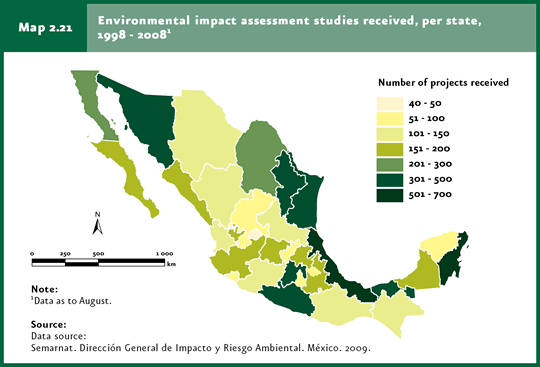
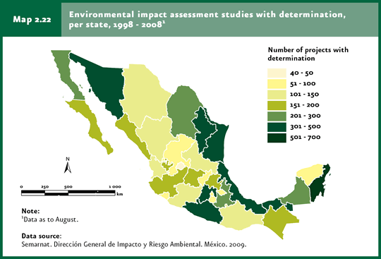
The states that had the highest number of projects submitted for environmental impact assessment over the past years are Quintana Roo, Veracruz and the State of Mexico; by contrast, some of the states with the lowest demand of project assessments are Aguascalientes, Yucatan, Zacatecas, Queretaro, Tlaxcala and Morelos (Map 2.21; Cuadro D4_IMPACTO00_01). The total number of projects processed by state is shown in Map 2.22.
The Environmental Information and Management Center (CIGA in Spanish), which is part of Semarnat’s Undersecretary for Environmental Protection Management, addresses the information needs derived from management processes related to environmental impact and risk, integrated pollution management, federal maritime-terrestrial zone, coastal environments, wildlife and decentralization of forest services and soil. Its website includes information on the status of any environmental impact assessment study by entering its code, as well as the one of any administrative procedure under way at Semarnat.
Notes 5Although agave plants, prickley-pear cacti and other succulent species of arid and semi-arid zones are not trees, these are the most suitable species for recovering these areas for their resistance and role in ecosystems, such as soil protection and runoff control.
|