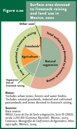
Livestock-free natural vegetation may reach 27% of the remaining area in the country. |
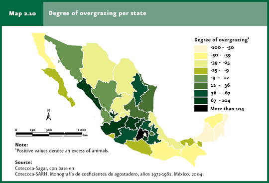
In 24 states of the country, the number of head of cattle exceeds the ecosystems’ capacity to maintain them. |
| CHAPTER 2. TERRESTRIAL ECOSYSTEMS |
FACTORS RELATED TO CHANGES IN LAND USE A number of hypotheses have been proposed to explain which factors are responsible for land-use changes. The commonest and most simple one contends that population growth creates an ever-increasing demand for resources and, consequently, areas inhabited by natural communities are replaced by land dedicated to farming activities. Although it is widely acknowledged that population growth and its needs are important to explain the change in land use, this cause-effect relationship is far from simple. Human populations and farmland area do not grow at the same rate; over the past decades, in general terms, agriculture land has expanded more slowly than the world population, partly due to the increase in production efficiency. For this reason, the relationship between farmland growth and the processes of land-use change deserve an in-depth analysis. Other factors (also associated with population), including the growth of urban areas, also contribute to land-use modifications, although to a lesser extent.
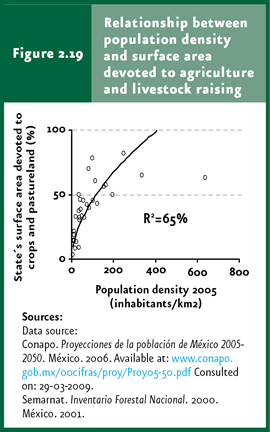
Population Evidently, human population size determines the extension of the territory used by man. There is a significant correlation between population density and the area dedicated to farming activities; the most populated states tend to dedicate a larger area to production (Figure 2.19). This relationship becomes more intense as there is more rural population dedicated to primary activities. For Mexico, this relationship is closer when the population of years ago is taken into account. In fact, the closest relationship is found with the population living in the 1950s. This historical lag in land use is, partly, the result of changes in the population labor structure. As a higher proportion of the population stops working on primary activities, the relationship between population density and the area of land dedicated to farming becomes less straightforward. In this sense, migrations and the abandonment of fields will likely affect land use in the years to come. Even more, this behavior means that today’s changes in the local population characteristics (particularly in the case of population dedicated to primary activities) will become evident in land use only after several decades have passed.
Growth of the Agricultural Edge The conversion of land to farming uses is one of the most important causes of deforestation in both Latin America and worldwide (FAO, 2000). According to information issued by the Board of Agriculture, Cattle Raising, Rural Development, Fisheries and Food (Sagarpa), the agricultural land in Mexico has remained relative unchanged over the past 20 years, at around 20 million hectares. For the past years this figure was around 21.5 million hectares. However, according to the Land Use and Vegetation Chart Series III, in 2002 the extension of agriculture land was nearly 31 million hectares. This means that during the past years some 10 million hectares cleared for agriculture have not been used for this purpose. One part of this area may have been left resting or was abandoned a while ago but has not developed secondary vegetation. This latter phenomenon is more important in arid zones, where the recovery rates of vegetation occur at a slower pace. In many cases, it is farmers themselves who prevent vegetation from recovering. A cleared parcel represents a means to care for their possession, adding value to it (a vegetated land has less market value relative to a clean one) and, frequently, clearing a piece of land also allows them to request credits or subsidies to the government. This may explain why one-third of the agricultural land remains uncultivated, in spite that it promotes soil degradation, hence reducing its production potential. If the area dedicated to farming activities is compared with the data from the 1993 and 2002 Land-Use and Vegetation Charts, the productive agricultural edge rose in 1.8 million hectares. Part of this growth has taken place at the expense of the primary natural vegetation, but a higher proportion comes from land previously used and already cleared of vegetation, or which were previously altered by man. One of the most frequent farming practices in tropical areas, that has even been considered as a sustainable farming model, is the so-called “slash-and-burn” or nomad agriculture. This system is based on cultivating land during one to three years, followed by a resting period of several years to enable the recovery of natural vegetation. In reality, the different pressures to increase food production have favored a substantial reduction in the resting times, leading not only to a drop in crop productivity (soil does not recover its fertility) but also preventing natural vegetation from recovering (refer to the Box Effects of the slash-and-burn practice on land use in the 2005 Report). Cattle raising is practiced throughout the country, comprising some 1.09 million square kilometers, that is, nearly 56% of the total country area based on 2008 data from the Technical Advisory Commission of Grazing Capacity (Cotecoca in Spanish). Considering this estimate and taking into account that by the year 2002 grasslands (both natural and induced) and cattle-raising areas comprised nearly 15% of the territory, the remaining 41% of cattle-raising land should be located in areas covered by natural vegetation. Therefore, if the remaining natural vegetation covers around 68% of the country (not including natural grasslands), one can conclude that livestock-free natural vegetation is almost 27% (Figure 2.20).
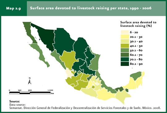
At a state level, the largest relative cattle-raising areas are located in Sonora (83% of the state), Coahuila (77%), San Luis Potosi (74%) and Zacatecas (72%). By contrast, the states with the smallest cattle-raising areas are Nayarit (14%), Federal District (11%) and Tlaxcala (6.5%, Map 2.9; Cuadro D2_AGRIGAN04_02).
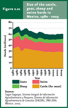
A substantial reduction has been observed in the number of head of cattle during the past two decades. In 1980, 67.6 million head were registered – considering bovine cattle, goats, sheep and pigs – whereas only 60.1 million head were recorded in 2005 (an annual 0.3% drop). The decline was more evident in the case of bovine cattle, which dropped from 34.6 million to 28.8 million head (-0.3% per year); the number of sheep and goats remained virtually unchanged during this period (Figure 2.21).
Considering the grazing capacity,in 24 states of Mexico the number of head of cattle exceeds the ecosystems’ capacity to maintain them. This situation is especially serious in the states of Mexico, Sinaloa and Jalisco (Map 2.10). To note, the states with the heaviest overgrazing does not necessarily match those with the highest cattle-raising density. Under an overexploitation situation like this one, even when the number of head of cattle drops, the grassland area needs to keep growing to accommodate the excess of animals, or change to intensive management systems to stop overstressing natural ecosystems.
Urbanization Although it is true that the urban area is relatively small at a national scale, it represents the land use that is growing at the fastest rate in some regions. For the year 2002, the country’s urban areas accounted for a little over 1.25 million hectares, or 0.6% of the country’s territory. Usually, these are flat areas suitable for agriculture that stop being productive. Whereas the direct impact of cities is small, these indirectly affect the land use involving large extensions to meet their needs for food, wood, leisure and waste disposal (refer to the section dealing with the ecological footprint in the Population chapter).
|