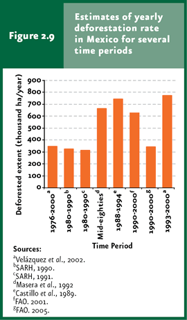
Over the past fifteen years, deforestation estimates in Mexico are highly dissimilar: they range from 316 thousand to nearly 800 thousand hectares per year. |
The deterioration of temperate and tropical forests in Mexico, including both deforestation and degradation, has affected nearly 514 thousand hectares per year since the 1970s to the year 2002. |
| In Mexico, 70% and 95% of shrublands and natural grasslands, respectively, might be overgrazed. |
Between 1991 and 2008, the mean number of wildfires exceeded 8 thousand 110 events, affecting an annual average of 240 thousand hectares. |
Between 1990 and 2007, the mean area affected by forest pests and diseases was 31 thousand 862 hectares per year. |
| CHAPTER 2. TERRESTRIAL ECOSYSTEMS |
LAND-USE CHANGE PROCESSES Some of the processes that determine land-use changes have been of particular interest. These include deforestation –the permanent change of a plant cover dominated by trees towards another lacking them3– alteration –also called degradation, which implies a modification of natural vegetation induced by man, but not representing a total elimination–, and fragmentation –the transformation of landscape leaving small patches of the original vegetation surrounded by altered land-. The land-use change in shrublands lacks a specific name, although sometimes it is denominated desertification, in the sense that it deals with the “environmental degradation in arid zones” (although desertification also includes subhumid areas). According to the General Law of Sustainable Forest Development, the country’s arid and subhumid shrublands are also regarded as forestal vegetation, so that the term deforestation may well be applied to these plant communities, even when deforestation is restricted to areas covered by trees according to several international organizations.
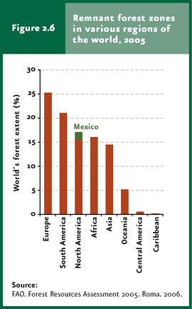
Deforestation The major cause of global concern about deforestation deals with global warming and the loss of environmental services supplied by temperate and tropical forests. These ecosystems provide key services: generation and retention of soil in sloped land, thereby preventing erosion; facilitation of water infiltration to subsoil, feeding groundwater reservoirs and purifying water and air. Furthermore, these are sources of consumer goods including timber, wood, food products and other “non-timber forest products” (food, fibers, drug products) of considerable importance for both industry and peasants in Mexico (FAO, 2000; GEO 3, 2002). Besides, plant communities dominated by arboreal life forms represent enormous carbon reserves as organic matter. Recent estimates reveal that the Earth’s forests store some 283 gigatons of carbon as tree biomass (FAO, 2005). This same document points out that the total amount of carbon retained in forest biomass, dead trees, fallen leaves and soil exceeds in about 50% the total amount of carbon in the atmosphere (FAO, 2005). When fire is used to clear the forest cover, carbon stored in it is released to the atmosphere, hence contributing to and aggravating the greenhouse effect. In the case of Mexico, preliminary estimates reveal that annual carbon dioxide emissions associated to land-use changes in Mexico in 1993-2002 rose to 89 thousand 854 gigagrams of CO2 equivalent, that is, about 14% of total GHG emissions in the country (INE-Semarnat, 2006). Conversely, vegetation sequestrates carbon from the atmosphere through photosynthesis, a process that is severely reduced when vegetation is cleared. The factor that makes the main contribution to the significant ”ecological deficit” in the Ecological Footprint calculated for Mexico (refer to the Population chapter) is the lack of a sufficient forest land to absorb our own GHG emissions, evidencing the importance of plant cover to attain sustainable development. A second cause for concern about deforestation deals with its negative impact on the planet’s biological diversity. When the forest cover is cleared, not only several species are directly eliminated, but the local environmental conditions are also seriously disrupted. Many organisms are incapable of surviving under the new environmental conditions, either because their tolerance limits are not sufficiently broad, because some resources essential for their survival are eliminated during deforestation (e. g. food, shelter, nesting sites, etc.) or because the conditions under which these organisms interact with other species change (e. g. through the effects on specific competition), leading to species displacement. In the case of Mexico, as a megadiverse country, this issue is particularly relevant. According to FAO (2007), which considers that forests include no less than 10% of the total area covered by tree canopy, in 2005 forests covered 3 thousand 952 million hectares worldwide, that is, about 30.3% of the Earth’s terrestrial regions. The main forest areas are located in Europe (25.3% of the world’s forests), followed by South America (21%) and North America (17.1%, with Mexico contributing with 1.63%; Figure 2.6).
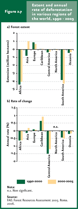
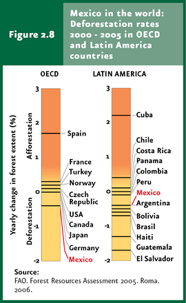
According to the above assessment, world deforestation, mostly to transform forests to farmland, have proceeded at a rate of million hectares per year. Although the net loss rate has dropped relative to the previous decade (1990-2000: 8.9 million hectares/year, at an annual rate of 0.22%), this loss remains high: it was calculated to occur at 7.3 million hectares per year for 2000-2005 (0.18% annually). At a world level, during the period between 2000 and 2005, South America was the region that lost the greatest forest area (4.2 million hectares), followed by Africa (4 million hectares; Figure 2.7a). By contrast, forest areas expanded in 666 thousand and one million hectares during 2000-2005 in Europe and Asia, respectively. However, when this comparison considers deforestation rates, Central America and Africa are the regions with the highest estimates for the periods 1990-2000 and 2000-2005 (Figure 2.7b). It is worth noting that Mexico is the only OECD country where forests keep declining (Figure 2.8).
The issue of deforestation in Mexico involves a huge disparity in the estimates obtained from different sources. Only in the past fifteen years the estimated figures range from 316 to nearly 800 thousand hectares a year (Figure 2.9; refer to the Box Deforestation rates in Mexico). The two most recent change-rate estimates in the country were issued by the Institute of Geography, Mexico’s National Autonomous University (UNAM) for 1993-2000 (Velázquez et al., 2002) and by the National Forestal Commission (Conafor) to be incorporated into the 2005 Forest Resources Assessment (FRA) (FAO, 2005). UNAM’s estimate was based on the comparison between the forest inventories available by 1993 (according to a preliminary version of INEGI’s Land Use and Vegetation Chart Series II) with those recorded in the Vegetation Chart of the 2000 National Inventory of Forest Resources elaborated ex profeso by UNAM itself based on satellite images recorded in the year 2000. For its part, the report submitted by Conafor to FAO was based on an especially explicit comparison of the forestal areas recorded in INEGI’s Land Use and Vegetation Chart Series II (restructured version) with the Land Use and Vegetation Chart Series III also elaborated by INEGI based on satellite images recorded in the years 1993 and 2002, respectively.
UNAM’s estimate indicates that, during the period 1993-2000, the loss of temperate and tropical forests in our country took place at a rate of 776 thousand hectares per year (1.14% annually). By contrast, the estimate derived by Conafor amounts to 348 thousand hectares per year for 1990-2000. A key difference between these two figures is that Conafor’s estimate was based on FAO’s criteria considering that an area is deforested only when it has been converted to other land uses such as agriculture, cultivated and induced grasslands, water reservoirs or urban areas. This definition of deforestation differs from the one used in UNAM’s assessment, which is based on the net differences between areas covered by arboreal vegetation (e. g. temperate and tropical forests) in 1993 and 2000. Given these differences in the estimation methodology, considering not only the resulting figure but the context is key for the correct interpretation of the information. These two estimates indicate that, throughout the last decade, the country lost between 3.5 and 5.5 million hectares of temperate and tropical forests, with primary vegetation being the one displaying the most severe losses. Deforestation depends on a number of factors, but one of the most important driving forces is economy, which favors those activities that produce the highest short-term profit. Timber exploitation to meet market needs fosters deforestation, making intensive exploration profitable despite relative low prices. The economic models predict that timber prices promote a change in land use both when these are high – since forests are cleared for selling timber – and when prices are low – since there are no incentives to preserve forest areas. Likewise, the rise in farming product prices leads to deforestation, since the non-forestal uses of land are more profitable (Cemda-Céspedes, 2002). Furthermore, the economic value of a given forest is low when selective timber extraction has depleted it from the most profitable tree species. Although this activity does not eliminate the forest cover immediately, it eventually results in deforestation, given that producers may get a higher profit by clearing impoverished forests to convert the land to other productive activities. This logic explains why perturbed temperate and tropical forests are later cleared and converted to land dedicated to farming activities in preference to primary vegetation. Alteration followed by deforestation is the most frequent land-use change process in Mexico, especially in the case of tropical rainforests (Cemda-Céspedes, 2002; refer also to Figure 2.5). Similar to the global phenomenon, farming activities in Mexico have been identified as the main cause of deforestation, followed in importance by illegal clearing (although figures on this activity are necessarily incomplete and revealing huge differences depending on the source consulted). Wildfires are also a significant deforestation factor; from these, virtually 40% are related to farming activities like slash-and-burn practices or grassland renewal through fire. Frequently, an area subjected to fire does not recover, as it is immediately dedicated to other uses such as farming or urban development. For this reason, an important fraction of fires are clandestine, provoked for invading forest areas protected by law or other local institutions (refer to the section Other threats to terrestrial ecosystems below for further details on wildfires).
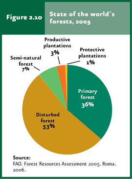
Alteration of temperate and tropical forests A less visible but maybe equally important process in terms of its environmental and economic effects is the degradation or alteration of temperate and tropical forests. Although this process does not involve the total clearance of the tree cover (as opposed to deforestation), it may lead to substantial changes in both the composition and density of species living in these ecosystems, which in turn affects their structure and functioning. The alteration of natural ecosystems also involves direct negative effects on environmental services, and hence on the possibility of a sustainable use. According to the most recent global assessment of forest resources (FAO, 2006), only 36% of the remaining forests worldwide are primary vegetation, being lost at a rate of 6 million hectares per year (Figure 2.10). The case of Mexico is also cause for concern, since today only 48.6% of the country’s area is covered by primary or slightly altered vegetation (according to the Land Use and Vegetation Chart Series III), whereas secondary vegetation – considering only temperate and tropical forests – is on the rise at a rate close to 130 thousand hectares per year (during the period 1993-2002), with temperate forests being the ones suffering the heaviest degradation (nearly 252 thousand hectares per year).
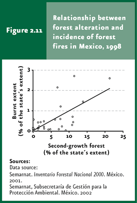
Both deforestation and alteration negatively affect the goods and services supplied by natural ecosystems. When deforestation and alteration are taken together, an approximation of the global vegetation “deterioration” rate can be derived. From the 1970s to the year 2002, the annual deterioration (deforestation + degradation) rate of temperate and tropical forests was 514 thousand hectares per year, that is, slightly more than twice as high as the deforestation rate sensu stricto (221 thousand hectares per year). This figure evidences the impact of the alteration process in our territory; nevertheless, these are not being given sufficient attention. The secondary vegetation currently covering large areas of the national territory results from both the regeneration of previously deforested land and the deterioration (with incomplete tree clearance) of the primary vegetation. However, the information currently available to quantify the relative importance of these two aspects is insufficient. The alteration type most closely resembling deforestation is selective timber extraction. Unlike temperate forests, each hectare of tropical rainforest includes tenths of different tree species, most of which lack commercial value, so that their commercial exploitation is not profitable. Sparsely distributed amongst them are precious-wood trees including mahogany (Swietenia) and red cedar (Cedrella), which are cleared without making good use of the surrounding trees. Another way of exploiting trees is to obtain wood. Although the local prohibition of cutting trees for wood is common in Mexico, this practice continues because of the need for fuel. One fifth of the country’s inhabitants use wood for cooking and, although there are no data on the total amount of wood consumed, the area from which this is obtained must be enormous. Besides the direct damages caused by wood and precious-wood extraction, the tree-cutting process affects between 30% and 50% of the adjacent trees (Kartawinata, 1979 in Challenger, 1998), leading to their death or making them more susceptible to the attack of pests and diseases. Although extensive cattle raising is more frequent in shrublands, it is also practiced in temperate and tropical forests, affecting large extensions of land. Cattle exerts a direct impact through trampling and plant consumption. In turn, these alterations alter the hydrological cycle, soil and vegetation, leading to a higher susceptibility to erosion, loss of biodiversity – or at least changes in the composition of plant communities – and the risk of fires. The reduction of the plant cover causes microclimate changes towards drier and warmer conditions due to the rise in incoming sun radiation penetrating into the forest and a higher penetration of wind. These, added to the activities like wood extraction that increase the amount of fuel in soil, favor wildfires. During the El Niño event in 1997-1998, the altered vegetation in Indonesia set on fire far more frequently than primary rainforests (Page et al., 2002). The same happened in Mexico, where the area affected by wildfires during the El Niño event in each that same year was closely related to the extension of secondary forests in the respective state; in fact, this factor accounts for 46.5% of the differences between states (statistically speaking) as to the area affected by wildfires. Some states lacking secondary forests were virtually unaffected by El Niño (Figure 2.11).
Vegetation alteration or degradation becomes accelerated with time, since the intervening processes interact with one another in a synergistic way. The outcome may be negligible in the beginning, but this synergy accelerates the change rates that ultimately lead to irreversible deterioration processes. Secondary vegetation is deforested at a faster rate relative to primary vegetation (Figure 2.5); opened roads for timber extraction are later used by peasants and farmers for settling in new areas; extensive cattle raising leads to erosion; wood cutting promotes wildfires; perturbed vegetation is much more susceptible to natural disasters (such as hurricanes, drought or fires) than primary vegetation. Although deforestation is typically an acute disturbance, alteration corresponds to a chronic state, the effects of which are accumulative, synergistic and occur progressively faster until they become irreversible (refer to the Box Catastrophic changes in ecosystems in the 2005 Report).
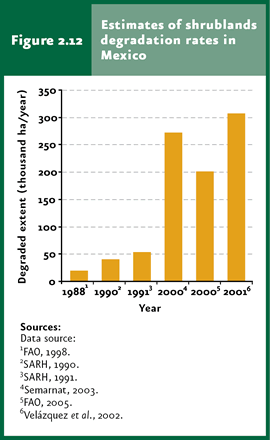
Shrubland Degradation Shrublands, locally known as “huizachales” and “mezquitales”, characteristic of Mexico’s arid zones, have also been deteriorated by man. However, the importance of this perturbation has been neglected in many cases, as these ecosystems are regarded more a nuisance than a resource. The erroneous concept that deserts are an undesirable downside of human activities is common; contrary to this idea, Mexican deserts are ecosystems with a high species richness, many of these species being endemic of Mexico. The rate at which arid shrublands are being converted into other land uses is even harder to assess than deforestation (Figure 2.12). According to national inventories, shrublands represent the ecosystem being transformed into other uses at the slowest pace and which is, therefore, preserved mostly as primary vegetation (92% in the year 2002, based on the Land Use and Vegetation Chart Series III). In absolute terms, however, this degradation level is not negligible, as secondary shrublands comprise more than 41 thousand square kilometers, an extension equivalent to Yucatan or Quintana Roo.
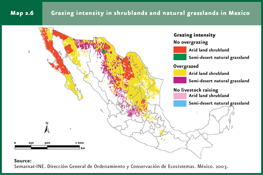
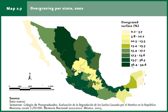
Shrublands may display important physiognomic variations, even within a small area. The vegetation resulting from an alteration in a given place may be perfectly natural in another. For this reason, it is extremely difficult to determine how the primary vegetation in any given location might have been, or if, alternatively, this actually represents secondary vegetation; this is most difficult if assessment are made based solely on remote sensing methods and when no direct field studies are available. Considering that most shrublands are used for cattle raising, an analysis conducted by the National Institute of Ecology (INE in Spanish) using alternative techniques to determine degradation reveals that, in many municipalities across the country, the number of head of cattle exceeds the ecosystem’s maximum capacity, and that 70% of shrublands are overexploited, leading to degradation processes. This figure differs markedly from the 7 to 8% of secondary shrublands described in the Land Use and Vegetation Charts Series I (for the decade of the 1970s), Series II (1993) and Series III (2002). According to the INE investigation, only the shrublands of eastern Coahuila, the Altar Desert and central Baja California are not overgrazed. Overgrazing also affects 95% of Mexico’s natural grasslands, which grow predominantly in Mexico’s arid north (Map 2.6). Semarnat, based on the study of anthropic soil degradation (Semarnat-Colegio de Postgraduados 2002), conducted an estimate of overgrazing by state in the country (Map 2.7); this study reveals that the area affected by overgrazing amounts to some 47.6 million hectares, equivalent to 24% of the national area and approximately 43% of the area dedicated to cattle-raising in the country.
Although wildfires are generally related to temperate forests, most of the affected area usually corresponds to grasslands, shrublands and arbustive vegetation. During 1998-2008, the area of shrubland affected by wildfires ranged between 35 and 49% of the total area burned down in the country. Arid shrublands are extremely fragile ecosystems. The ecological rhythms in deserts are amongst the slowest ones in the world, so that any effects of human activities take a long time to be eliminated from the ecosystem and, therefore, build up through time. Consequently, arid vegetation is extremely susceptible to alteration and degradation processes, since the acceleration and synergistic processes that characterize chronic disturbance are particularly intense; in fact, they have been given a special name in this case: desertification (also refer to the section dedicated to this topic in the Soils chapter). When the plant cover of a desert is altered, the environmental conditions generally become even drier, and maximum temperatures rise. The plants and animals that are able to withstand these modified environments correspond to more arid zones, so that the affected area becomes more arid than before. Hence the term “desertify”: “create deserts”. Attempts have been made to apply this model to other ecosystems. For instance, it has been proposed that, to a great extent, Libanese shrublands have resulted from desertification. It is hard to determine the extent to which the Libanese cedar forests disappeared as a result of human activities or, alternatively, due to natural historical trends. The most accepted definition of desertification includes these possibilities and points out that “desertification is the environmental degradation in arid, semi-arid and dry subhumid areas as a result of various factors, including climate variations and human activities” (United Nations Convention to Combat Desertification). Degradation involves both the plant cover and the soil supporting it (also refer to the topic Soil Degradation in the Soils chapter).
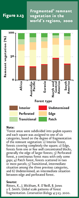
Fragmentation When the original vegetation is eliminated, usually small intact stands remain scattered within a heavily degraded matrix. As a result, the natural vegetation of gorges and mountain peaks constitute the only remnants of original vegetation in many regions of Mexico. Each of these vegetation “islands” usually shelters a lower number of native species relative to an equivalent area located within a large extension of original vegetation. This is due to the fact that several of the native species cannot survive in small fragments, and that multiple degradation processes take place along the borders. For these reasons, when the aim is wildlife conservation, it is not sufficient to determine the area covered by vegetation. Having a single large extension of rainforest comprising 100 thousand hectares is not equivalent to having one hundred fragments of one thousand hectares each. Ritters and coworkers (2000) reported the earliest fragmentation estimates for temperate and tropical forests at a world level. Figures are disturbing: a mere 35% of the forested land is neither fragmented (i.e., forming continuous areas of over 80 square kilometers) nor suffering border effects (that is, located more than 4.5 kilometers away from a border). At a regional level, North and Central America displayed the highest proportion of fragmented forests worldwide (above 45%); considering the type of ecosystem, tropical rainforests displayed the most extensive fragmentation (Figure 2.13).
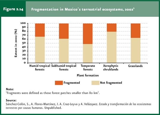
In the case of Mexico, the most recent estimates on ecosystem fragmentation are reported in the work by Sanchez-Colon and coworkers (unpublished data), based on the 2002 information included in INEGI’s Land Use and Vegetation Chart Series III. In order to determine the extent of ecosystem fragmentation, fragmented areas were regarded as those stands of natural vegetation with an area smaller than 80 square kilometers, considered as the minimum area suitable for maintaining optimal conditions for the diversity and the biological population in certain ecosystems. According to these researcher’s findings, 33% of the evergreen rainforest area in Mexico is fragmented, similar to semi-deciduous rainforests (38.5%; Figure 2.14). Furthermore, 52.1% of the area covered by temperate forests is fragmented, although the study points out that this result may be influenced by some vegetation types that do not stretch over large areas by themselves, as is the case of the “ayarin” or “tascate” forests. This is also true of natural grasslands, displaying a fragmentation of up to 36.1% of their total area, but the natural distribution of which (e. g. alpine grasslands) also displays small patches. In the case of xerophilous shrublands, the study calculated that 20.6% of the total area covered by this vegetation type in Mexico in 2002 might have been fragmented.
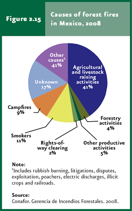
Additional threats to terrestrial ecosystems Wildfires occur naturally and are a key factor for the natural dynamics in many terrestrial ecosystems worldwide, mostly in temperate forests. Wildfires lead to an increase in nutrient availability in soil and trigger ecological succession processes, hence contributing to maintain biodiversity (Matthews et al., 2000; SCBD, 2001c). However, today and to a great extent due to human activities and intervention, wildfire occurrence patterns have been modified. Currently, many wildfires occur in zones not previously affected by them, whereas these have been eliminated in areas previously subjected to periodical wildfire regimes (SCBD, 2001c; Castillo et al., 2003). The effects of wildfires on ecosystems are diverse and depend on fire intensity and frequency. The most evident effect is the removal of standing plant biomass which, along with the elimination of seedlings of tree species, delays or restrains natural regeneration, besides fostering the spread of forest pests and diseases (Matthews et al., 2000; Castillo et al., 2003). The direct effect of wildfire on animals living in natural communities is death, and the indirect effects include loss of habitat, territory and feeding grounds, as well as the displacement of territorial birds and mammals (SCBD, 2001; Castillo et al., 2003). In the case of forest ecosystems potentially or actually subjected to exploitation, the effects of wildfires are evident at to levels: on one hand, on the deterioration and loss of these resources and, on the other, on the reduction in the quality of their environment. As for the former, the heat released during a wildfire causes the death of plant tissues and leads to malformations, thereby reducing timber quality (Castillo et al., 2003). Wildfire can also eliminate seedlings of commercial species completely and favor the spread of forest pests and diseases (Matthews et al., 2000; Castillo et al., 2003). The two key factors affecting wildfires in terrestrial ecosystems in many countries include the uninterrupted forest clearance and the use of fire for preparing cropland as part of the agricultural practices; however, bonfires and lit cigarettes thrown by careless smokers are also causes of wildfires. In 2008, the main causes of forest fires in Mexico were agricultural burning practices (41%; Figure 2.15).
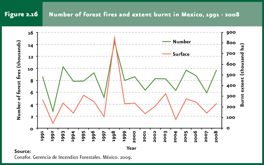
The number of wildfires in Mexico and the affected area have remained relative unchanged over the past fifteen years (Cuadros D3_RFORESTA05_01 and D3_RFORESTA05_02; Figure 2.16). Between the years 1991 and 2008, the mean number of wildfires was 8 thousand 110 events, affecting an average of 240 thousand hectares. However, there have been years with particularly intense wildfires. This was the case of 1998, which affected extensive areas both in Mexico and other regions of the world: 14 thousand 445 wildfires were recorded in Mexico that year, affecting a total area of about 850 thousand hectares.
Wildfire intensification has resulted from a number of intrinsic and extrinsic factors. For instance, some forest fire fighting practices merely attempt to avoid the occurrence of any kind of wildfire. As a result, combustible materials (leaves, dry branches, etc.) accumulate and, when a wildfire does occur, it reaches huge proportions. It has also been observed that some meteorological phenomena may be associated with wildfires. In Yucatan, great hurricanes are generally followed by great wildfires, as occurred in Sian Ka’an in 1989 after hurricane Gilberto (López-Portillo et al., 1990), or as might be the case after hurricanes Stan and Wilma, which affected extensive forests across the Yucatan Peninsula and Chiapas in the year 2005. Another major oceanic and meteorological phenomenon which affects the occurrence of wildfires is the one known as El Niño, which causes droughts and temperature increases in Mexico. As to the affected area, the highest percentage of vegetation generally corresponds to natural grasslands and shrublands, followed by forests. In the year 2008, the percentage of affected vegetation for these types was 43.5, 45 and 11.5%, respectively (Figure 2.17).
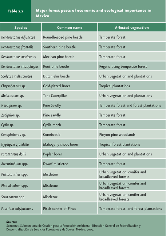
Besides human activities and forest fires, pests and diseases may also affect terrestrial ecosystems. Forest pests and diseases occur naturally in temperate and tropical forests, being even necessary for the ecosystem’s functioning. However, man can cause an increase in their frequency beyond the normal incidence, with the potential to seriously affect the forest condition. Forest pests are either insects or pathogens that cause mechanical or physiological damage to trees, including malformations, stunt growth, debilitating conditions or even death, all of which lead to considerable ecological, economic and social impacts. These are regarded as one of the major causes of alteration in the country’s temperate forests. Today, some 250 insect and pathogen species are recorded which affect trees in Mexico (Table 2.2).
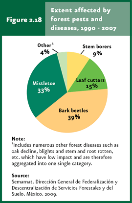
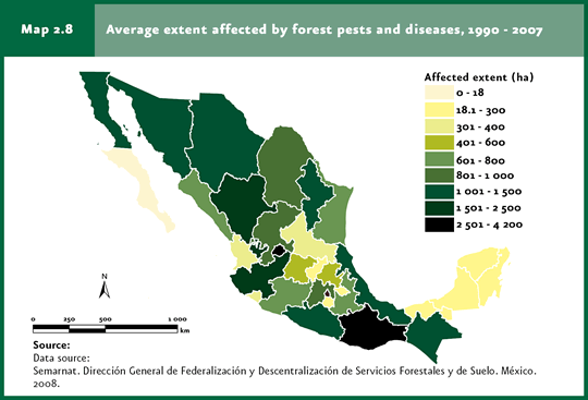
Among the natural factors facilitating the attack of pests are meteorological phenomena such as droughts, hurricanes and snowfalls, as well as other natural phenomena like wildfires. However, human activities also foster attacks. Unregulated grazing and exploitation, poor forest management, the introduction of pest and pathogen species from other geographic regions and induced fires all facilitate the attack by forest pests. As a result of the periodical monitoring conducted by Semarnat in the country’s forest areas, the mean area annually affected by forest pests and diseases was 31 thousand 862 hectares during the period 1990-2007 (Cuadro D3_RFORESTA06_01). Of the area accumulated in this period, the highest proportion was affected by bark beetles (39% of the total), followed by mistletoe (33%) and defoliating insects (15%; Figure 2.18). The states with the largest average of affected forest area between 1990 and 2007 were Oaxaca, Aguascalientes, Durango and Jalisco (Map 2.8).
Note
|