Up to the year 2002, 222 thousand km2 of tropical rainforests, 129 thousand km2 of temperate forests, 51 thousand km2 of shrublands and nearly 60 thousand km2 of grassland had been lost in Mexico. |
Considering only primary vegetation, 14.4 million hectares of temperate and tropical forests and 3.2 million hectares of shrublands were lost between the 1970s and the year 2002. |
Farmland went from 40 million hectares in the 1970s to nearly 50 million hectares in the year 2002. |
| CHAPTER 2. TERRESTRIAL ECOSYSTEMS |
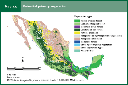
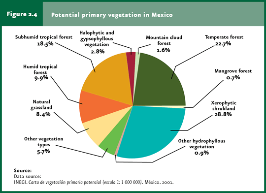
In the past 50 years, man has transformed the world’s ecosystems more rapidly and extensively than in any other period of the history of mankind (refer to Box The transformation and loss of the world terrestrial ecosystems). This rapid and profound transformation have led to unprecedented impacts on local, regional and global environmental processes, leading to an accelerated loss of biodiversity, reducing water availability, polluting air and soil and releasing large amounts of greenhouse gases to the atmosphere. Land-use inventories have been elaborated in Mexico since some 40 years ago. However, these are not directly comparable, as these used different information sources (e. g. aerial photographs, satellite images, etc), technological tools (e. g. paper maps, digital charts, geographical information systems, etc.) and several land-use classifications. Nevertheless, although quantitative estimates may not be sufficiently precise and should be interpreted with caution, the available information does reveal the existence of trends. Of the available land-use inventories, those most directly comparable are the Land Use and Vegetation Charts Series I, II and III, scale 1:250 000, elaborated by the National Institute of Statistics and Geography (INEGI). Series I is based on the interpretation of aerial photographs taken in the 1970s, while Series II and III were developed from satellite images recorded in 1993 and 2002, respectively. Separately, INEGI also elaborated the Chart on Potential Primary Vegetation at a scale 1:1 000 000, which describes the vegetation that likely covered the national territory before its transformation by human activities. According to the Potential Primary Vegetation Chart (Map 2.5),shrublands comprised 28.8% of the territory, followed by tropical rainforests (28.4%) and temperate forests (24.3%; Figure 2.4). In the 1970s (according to Series I), 75% of original forests, 69% of rainforests and 61% of original natural grasslands were still preserved (Figure 2.2). By the year 2002, according to Series III, 73% of temperate forests, 60% of rainforests, 91% of shrublands and 63% of grasslands remained, representing a net loss of nearly 222 thousand km2 of rainforests, 129 thousand km2 of temperate forests, 51 thousand km2 of shrublands and nearly 60 thousand km2 of grasslands. Although most of these changes took place before the 1970s, over the past decades substantial losses were still recorded (exceeding 100 thousand hectares per year), particularly in the case of tropical rainforests and shrublands.
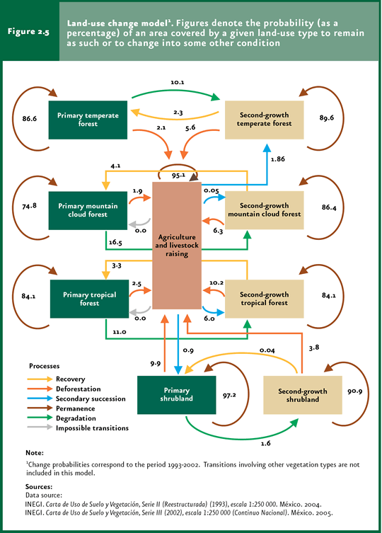
When the changes of natural ecosystems to other land uses take into account the change in the primary vegetation, these are still more significant. In the 1970s, primary tropical rainforests comprised 34% of their original extension; 62% of temperate forests, 89% of shrublands and 45% of grasslands remained. By the year 2002 primary tropical rainforests represented only 21% of their likely original extension; primary temperate forests, 47%; primary shrublands, 83%; and grasslands, 39% (Figure 2.2). In the period between the 1970s and 1993, nearly 14 million hectares of primary temperate and tropical forests, shrublands and grasslands were cleared to allocate land to other uses, or were altered and replaced by secondary communities at an average rate of some 823 thousand hectares per year. These transformations affected to a greater extent temperate forests (some 276 thousand hectares per year) and tropical rainforests (some 341 thousand hectares per year). More recently, although the alteration or transformation of primary vegetation has decreased, it remains significant. From 1993 to 2002, a total of 4.6 million hectares (an area slightly larger than Quintana Roo), previously covered by temperate forests, tropical rainforests, arid shrublands and primary grasslands were either dedicated to other uses or replaced by secondary communities at an average rate of 515 thousand hectares per year. During this period, primary forests suffered the heaviest disruption (2.6 million hectares in all), being cleared or altered at a rate of 293 thousand hectares per year; the total extension of primary tropical rainforests affected during this period was one million 261 thousand hectares, at a rate of nearly 140 thousand hectares per year (Figure 2.2). In general, tropical rainforests have been the country’s terrestrial ecosystems that have suffered the heaviest alteration by human activities in terms of the area cleared (a little over 22 million hectares), the remaining proportion of the original extension (nearly 60%) and the magnitude of disruptions (only 35% of current rainforests are primary vegetation). Considering the net area lost, rainforests are followed by temperate forests, which have lost nearly 13 million hectares and the extension of which currently accounts for 73% of its original extension. Arid shrublands underwent a reduction in area from 56 million hectares originally occupied to just 51 million hectares (including primary and secondary communities). These losses are especially important considering that tropical rainforests and arid shrublands are the ecosystems containing most of the country’s biodiversity and, particularly, that arid shrublands concentrate a large amount of endemic species (refer to the Biodiversity chapter). Besides vegetation clearing or the total elimination of the original plant cover to allocate the area to other land uses, another important process deals with the degradation of natural communities. From the 1970s to 1993, the secondary vegetation (considering temperate and tropical forests, shrublands and grasslands) rose in some 8 million hectares at a rate of 476 thousand hectares per year. Secondary temperate forests rose in a little over 4 million hectares, an area slightly smaller than the loss of primary forests over the same period of time. Although the extension of secondary rainforests increased in nearly 2.3 million hectares, 5.8 million hectares of primary rainforests were lost, leading to a global net loss of 3.5 million hectares of tropical rainforests over this 17-year period. More recently, from 1993 to 2002, the extension of secondary temperate forests rose in more than 2 million hectares, an area slightly smaller than the one lost by primary forests over the same period (2.6 million hectares). By contrast, both primary and secondary rainforests underwent a global net loss of 1.3 million hectares (Figure 2.2). By contrast, farming land has expanded steadily through time. In the 1970s, grasslands dedicated to cattle raising comprised an area above 14 million hectares, whereas cropland stretched over some 26 million hectares. From the 1970s to 1993, these anthropic uses grew in 6.5 million hectares to cover a total area of 46.8 million hectares in 1993, at a rate of 380 thousand hectares per year. From 1993 to 2002, cultivated or induced grasslands expanded in some 91 thousand hectares and, altogether, the areas dedicated to agriculture and cattle-raising grasslands rose in nearly 3 million hectares to reach a total extension of 49.8 million hectares in 2002. The transformation of vegetation to farmland is always more intense in the case of secondary vegetation relative to primary vegetation. This phenomenon of a first degradation or alteration of vegetation followed by the eventual transformation to other land uses is, undoubtedly, responsible to a great extent for the high rate of natural vegetation losses in Mexico. The dynamics of the transformation between different uses may be conceived as a flow of land passing from one land-use type to another, as shown schematically in Figure 2.5.
|