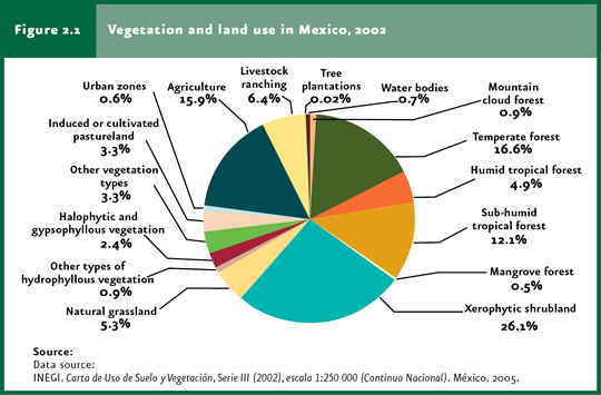
In the year 2002, 72.6% of the country was covered by natural communities under various degrees of conservation; the remaining area had been converted into farmland, urban land and other anthropic covers. |
Shrublands represent the dominant plant community in the country (26.1% of the territory), followed by temperate and tropical forests which, together, cover 33.6% of the area. |
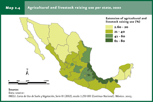
The states that have inflicted the heaviest transformation to their terrestrial ecosystems into farmland to date are Veracruz, Tlaxcala and Tabasco. |
| CHAPTER 2. TERRESTRIAL ECOSYSTEMS |
Ecosystems in general, and terrestrial ecosystems in particular, have supported human populations since early times: these have supplied multiple goods, including food (meat, fruits, vegetables and spices), timber for construction, wood, paper and fibers for fabrics, among many others. Additionally, these supply environmental services like air and water purification, soil generation and conservation, waste breakdown, nutrient recycling and transfer, protection of littorals against wave erosion, partial climate stabilization and buffering against extreme climates and their impact, just to mention some of the major contributions. However, the huge global population growth during the twentieth century, along with an unprecedented industrial and urban development, brought about the most significant transformation of terrestrial ecosystems ever recorded by man. Extensive ecosystem areas were either disrupted or converted into cropland and cattle-raising grasslands; others were cleared to develop towns and cities, build roads, electricity power infrastructure and water reservoirs. The magnitude of these changes has been estimated to reach levels between 33 and 50% of the world terrestrial area (Vitousek et al., 1997). Mexico has been no exception in this process of terrestrial ecosystem degradation and loss. A significant proportion of the country’s area has been transformed into agriculture land, grasslands and urban and rural areas. Some ecosystems that previously comprised extensive areas of the country have been reduced today to small remnants keeping the original characteristics plus broad areas of degraded land. This chapter describes the current status of Mexico’s terrestrial ecosystems, focusing specifically on the processes and factors that have led to their transformation in recent decades. Additionally, a section is included that addresses the use of these ecosystems, mostly as to the exploitation of timber and non-timber products. The final section deals with the government responses aimed at preserving the remaining plant cover, as well as those focused on the recovery and sustainable use of natural resources present in the country’s terrestrial ecosystems.
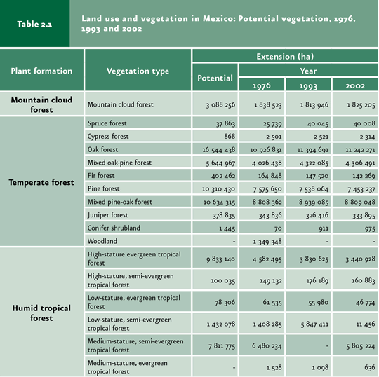
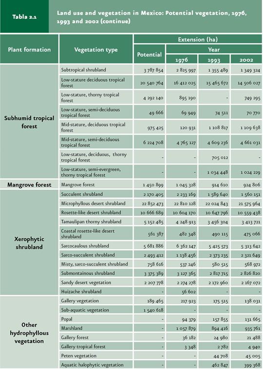
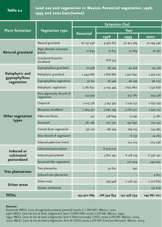
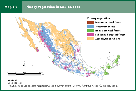
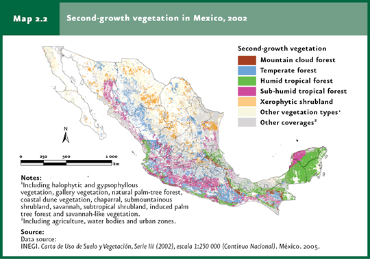
NATURAL VEGETATION AND SOIL USE IN MEXICO The way in which a piece of land and its plant cover are used is known as “land use”. The most recent assessment of land uses in Mexico is the Land Use and Vegetation Chart Series III, scale 1:250 000, elaborated by the National Institute of Statistics and Geography (INEGI in Spanish), which describes the vegetation in the year 2002. Series IV, which will include information on land use and vegetation for 2007 (scale 1:250 000) will be available in 2009. Given the number of vegetation types and land uses included in this chart, their grouping for analysis purposes is inevitable. Table 2.1 shows these groups, along with the respective area and those obtained from other previous land-use charts for 19761 and 1993 and the one for the original vegetation. For further information on the characteristics of some types of natural vegetation, refer to the Box The Vegetation of Mexico.
According to this chart, 72.6% of the country was covered by natural vegetation in 2002; the remaining land had been converted to farmland, urban land and other anthropic covers (Figure 2.1). However, the remnant natural vegetation was far from being unaltered by man: 48.6% of the territory (67.2% of the remaining vegetation) comprised primary vegetation (that is, the one preserving most of the species present in the original ecosystem), with no signs of substantial disruption and which is, in principle, the one with the greatest importance in terms of biodiversity and supply of environmental services); in general, the tropical rainforest is the most affected ecosystem (only 35.4% of its area corresponded to primary rainforest; Maps 2.1 and 2.2). For perspective, only 36% of the world’s forests2 are primary vegetation (FAO, 2005).
Of the remaining area covered with natural vegetation, shrublands represent the dominant ecosystem (26.1% of the territory); at least 8.1% of today’s shrublands is secondary vegetation, although this figure may be larger as many areas are subjected to extensive cattle raising. For their part, temperate and tropical forests jointly account for 33.6% of the national territory, the area covered by primary rainforests being smaller than the one covered by primary temperate forests (11.7 and 22.1 million hectares, respectively; Figure 2.2).
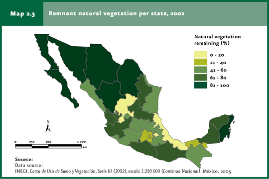
The states with the largest proportion of land covered by natural vegetation (regardless of its degree of conservation) were Baja California Sur (93.5%), Quintana Roo (92.7%), Coahuila (92%), Baja California (90.9%), Chihuahua (89.3%) and Sonora (87.7%), with over 80% of their territory. By contrast, in Tlaxcala (18.2%), Veracruz (19.8%), Federal District (28%), Tabasco (29.3%), Morelos (34.6%) and Mexico (34.8%), the natural vegetation covers less than 35% of the area in each state (Map 2.3).
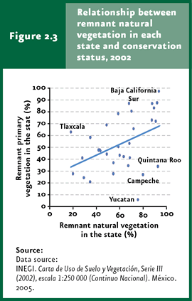
In general, the states with a high proportion of natural cover keep a significant percentage of primary vegetation (Figure 2.3). For instance, 97.3% of the remaining natural vegetation in Baja California Sur (covering 93.5% of the state) is primary vegetation. However, there are important exceptions to this trend, that is, states with broad areas of remaining secondary natural vegetation: Quintana Roo (with only 33.8% of remnant primary vegetation), Campeche (26.8%) and Yucatan (5.7%). By contrast, Tlaxcala keeps only 18.2% of its plant cover, although nearly 63% of it is considered primary vegetation.
Conversion of natural ecosystems to productive land has been especially intensive along the Gulf of Mexico littoral and in central Mexico. The states with the heaviest ecosystem transformation to allocate them to farming activities are Veracruz (75.5% of the territory), Tlaxcala (74%) and Tabasco (64.6%; Map 2.4). On the contrary, the states with the lowest farming area are Baja California Sur (2.6%), Quintana Roo (5.3%) Coahuila (6.1%) and Baja California (6.4%).
Notes 1Although the Land Use and Vegetation Series I Chart refers to 1976, information comprising virtually all the 1970s was used for its elaboration. 2According to FAO, forests are defined as vegetation covering more than half an hectare of the area, including trees more than 5 meters high and a with canopy covering at least 10%, or with trees capable of reaching these minimum limits in situ. This definition does not include land subjected to predominantly farming or urban uses. For this reason, the “temperate forest” and ”rainforest” categories in the classification system used in this chapter are included within FAO’s forest category.
|