| CHAPTER 4. BIODIVERSITY |
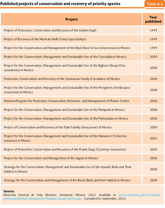
BIODIVERSITY PROTECTION In Mexico and the world, the implemented strategies to protect the biodiversity have mainly been aimed at two of their study levels: the one of the species and the one of the ecosystems. In the case of the species one, the development of the Projects of Conservation and Recovery of the Priority Species (PREP) stands out; these projects had their origin in the Program of Conservation of the Wildlife and Productive Diversification in the Rural Sector 1997-2000. Such program proposed a series of projects for a group of plants and animals that, according to experts, should be taken as priority species. As a result of these works, as of today, 16 programs have been prepared and published (Table 4.2).
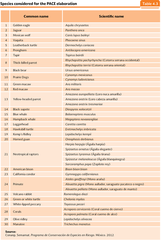
On the other hand, in 2007, the Program of Conservation of Endangered Species (Procer) was started; the Semarnat and other state ministers (Sedesol and Sagarpa, among other) are in charge of the program, whose main objective has been to achieve the recovery of some species (see the Box Conservation of priority species: the cases of some reintroduced species). Each one of the considered species within the Procer is attended by means of the Action Programs for the Conservation of the Species (PACE), which includes the strategies, specific actions and activities, scheduled in the short, middle and long terms, which are planned to help the conservation, protection and recovery of the population of the species. Nowadays, the Procer has a list of 30 species, operatively organized in three large groups: 1) marine turtles, 2) terrestrial and epicontinental species and 3) marine species, coastal and insular (Table 4.3).
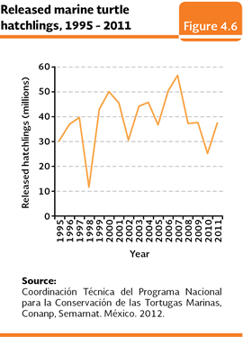
In addition to the attended species in the previous programs, one of the biological groups that have received a higher attention for its protection in the last decades is the one of the marine turtles. Although such reptiles perform a very important role in the balance of the marine and coastal ecosystems (León and Bjorndal, 2002), their populations in the whole world have been dramatically affected by the human activities, among them the incidental fishing, the coastal touristic developments, the pollution of the marine water, the illegal use of their flesh and the looting of their eggs for the human consumption. 6 out of the 7 known marine turtle species nest in the Mexican beaches; all of them are classified as endangered species according to the NOM-059-SEMARNAT-2010. The conservation of these species in the country has been carried out for over 40 years by means of the National program for the Conservation of Marine Turtles, currently under the responsibility of National Commission of Protected Natural Areas (Conanp), within the Procer. The protection activities are carried out by the 26 Centers for the Conservation of the Marine Turtles (10 beaches within the ANP classified as Sanctuaries and 17 with a Ramsar designation, which in some cases overlap each other, as it is the case of the turtle nesting beach Tierra Colorada which shares both denominations), as well as a Mexican Center of the Turtle. They, together, monitor over 500 coastal kilometers in 13 states of the country. The principal objective of the protection actions in the camps is the collection of eggs to protect them against the predation and looting to incubate them to obtain the larger number of possible offspring and to release them to their wildlife populations. Figure 4.6 shows the total amount of released offspring every year between 1995 and 20114. In this period, the annual average of released turtles of the six species in the Mexican beaches was 38.9 million of offspring. Along with the activities of the camps, in the principal turtle nesting beaches, the Federal Government through Profepa, the Marine Secretariat (Semar) and Conanp, carry out protection actions by means of surveillance of the beaches, with the objective to avoid the looting of the nests and the illegal catching of specimens.
For the case of the conservation of the ecosystems, two principal strategies have been followed. On one hand, the efforts on the issue of preservation of the integrity of the ecosystems and their environmental services stand out (Specifically through the creation of Protected Natural areas, the Ramsar sites, the establishment of priority marine sites, ecological regulations in marine and coastal areas and the Pay Programs for Environmental Services), on the other hand, the efforts oriented to the sustainable use of the biodiversity (i. e. the System of Management Units for the Conservation of the Wildlife, Suma), that, in an indirect way, conserves the ecosystems where the object species inhabit. In this last line there are also programs from other sectors (forestry, mainly) that promote the rational use of the biodiversity of the national forests, such as the Programs of Forest Development (Prodefor) and the Project of Conservation and Sustainable Management of Forest Resources (Procymaf). Details about these and other programs may be found in the chapter of Terrestrial ecosystems.
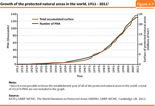
Protected Natural Areas (ANP) The creation of ANP has been in the last century one of the principal strategies used in the global sphere for the conservation of the natural ecosystems and their species. These are terrestrial or aquatic portions of the national territory representative of the diverse ecosystems, where the original environment has not essentially been altered and which provide ecological benefits are more recognized and valued (Conanp, 2010). In 1911, in the entire world, 141 areas had been declared as protected, which accounted 113,634 square kilometers; by 2011, over 130 thousand areas were recognized which covered over 24 million square kilometers (Figure 4.7). In Mexico, the creation of ANP has also been one of the most meaningful conservation strategies: it was formally started in 1917 during the term of President Venustiano Carranza with the decree to constitute the Desierto de los Leones as the first national park (Melo, 2002) Nowadays, the Conanp is responsible of all of the activities that are carried out in the federal ANP in the country.
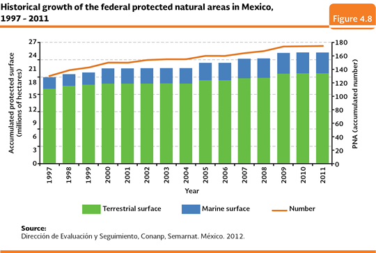
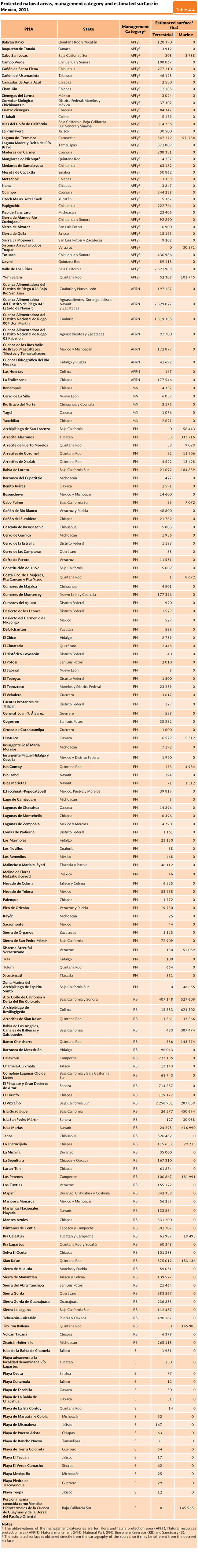
During the last years a meaningful effort to increase the number of protected areas has been made. In 1997 there were 130 federal ANP with a total surface of about 19.8 million hectares, in other words, 10.1% of the national surface. By 2011, 174 ANP were accounted and a protected surface slightly more than 25.5 million hectares, 20.7 million of them corresponded to terrestrial areas (about 81.2% of the total of the protected surface) and a little more than 4.8 million hectares (18.8%) marine areas (Figure 4.8; Map 4.2; Table 4.4; IB 6.1-6, 6.3-10, 6.3.1-4, 6.4.1-7 and 6.4.2-7).
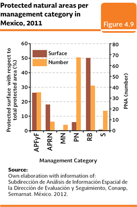
According to the General Law of the Ecological balance and the Environment Protection (LGEEPA), there are six management categories for the federal ANP: reserves of the biosphere (RB), national parks (PN), natural monuments (MN), areas of natural resources protection (APRN), areas of flora and fauna protection (APFyF) and sanctuaries (S). Besides, there are the parks and state reserves (PyRE) and the areas of ecological preservation of the population centers (ZPE). By 2011, the category with the largest number of decreed areas at a federal level was the one of national parks, with 67; however, its contribution related to the national protected surface was just 5.7% (Figure 4.9). The existing 41 reserves of the biosphere cover around 49.9% of the protected surface. Its principal function is to constitute themselves as research, conservation and sustainable regional development spaces. The 35 areas of flora and fauna protection cover 26% of the national protected surface, being mainly located in areas with a high wealth of flora or fauna or where species, sub species or restricted distribution habitats are found. The eight areas of protection of the natural resources mean 17.8% of the protected surface and, finally, the five decreed areas as natural monuments are just 0.1% and they host one or several natural elements which due to their unique, beautiful character, historical and scientific value, require to be incorporated to a regime of absolute protection.
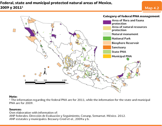
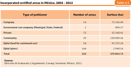
The federal ANP are not the unique ones that exist in the country, there have been an establishment of areas protected by the governments of the states, municipalities, and even by the ones called “certified”. By 2009, 296 state ANP have been decreed and 98 with a municipal character, which covered a surface of about 3.3 and 0.17 million hectares, respectively (Bezaury-Creel et al., 2009a and b). In the case of the certified areas, in 2008 the Conanp started the certification process of the areas of volunteer conservation as a strategy to incorporate new areas of the national territory into conservation schemes. These areas are considered as another category of ANP, with the same level of importance, but where their owners keep the property, management and governance of the area (Elizondo y López, 2009). In this sense, the certification is a unilateral process carried out by the proposer and where the Conanp participates as a notary of the will to conserve its lands as well as of the policies, criteria and actions that the promoter attempts to carry out to reach its goals. Between June 2002 and September 2012, a total of 324 certified areas have been incorporated; such areas cover 370,804 hectares in 19 states of the republic (Table 4.5).
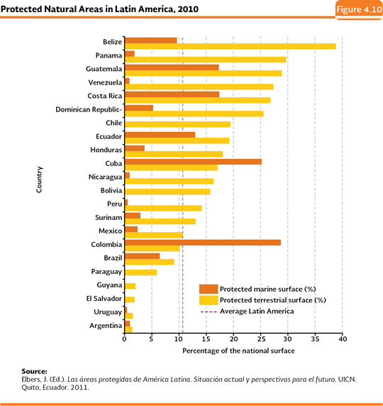
If the average of the national surface covered by the AN is compared to other countries and organizations, in 2012, it was slightly higher to the most recent average reported by the members of the Organization for Economic Cooperation and Development (OECD), which, in 2007, was 12.7%. In the same way, the national value is higher than the world average of 10.2% reported in the Indicators of The Millennium Development Goals in 2010. At the Latin America level, the protected terrestrial surface of our country in 2010 (10%) meant a percentage slightly higher than the general average of the region (Figure 4.10).
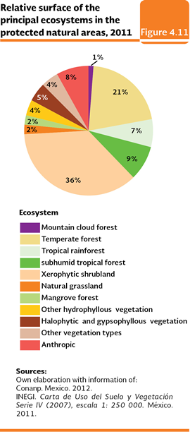
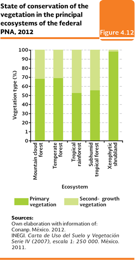
The federal ANP include most of the ecosystems present in the country. In the terrestrial portion what is predominant is the Xerophytic shrubland (36% of the protected surface, nearly 7.3 million hectares), the temperate forests (21%, 4.2 million hectares) and the subhumid tropical forest and tropical rainforest (9 and 7%, respectively, 3.1 million hectares as a whole; Figure 4.11). From the protected surface, 98% of the Xerophytic shrubland keep their primary state; followed by the temperate forests (with nearly 69% of their surface in that condition), the Mountain cloud forest (68%) and the subhumid tropical forest and tropical rainforest (55 and 52%, respectively; Figure 4.12).
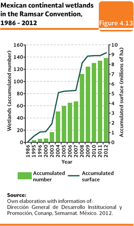
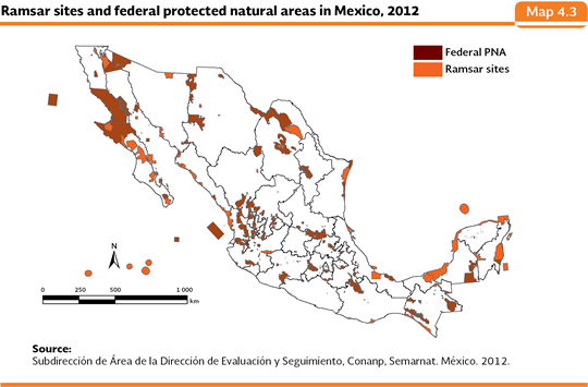
In respect to the continental aquatic ecosystems, in 2011, a total of 87 rivers and 3,628 kilometers of their beds were included in the total or partially within the federal ANP of the country. The rivers Santa María, Grande de Santiago, Bravo, Sabinas and San Fernando are the ones which have a higher length of their beds within the ANP. In the case of the marine ecosystems, in 2011 there were 32 marine ANP with a total surface of 4.8 million hectares, this is, 18.8% of the national ANP total surface (IB 6.3-10) Inside them, some of the most important reef systems of the country are protected, standing out, in the coast of the Pacific Ocean, Cabo Pulmo; in the Gulf of Mexico, the Veracruz Reef System; and in the Caribbean, the reefs in Cozumel and the Mesoamerican Reef Barrier (the last one is considered as the second largest and important one of the world after Great Reef Barrier in Australia). As a whole, in 2011, seventeen federal ANP protected these important ecosystems (IB 6.3.1-4). One of the instruments used to formalize the conservation strategies and the use of the federal protected natural areas is the called Management Program. These instruments, in addition to including aspects about the features of the site (i. e. ecological, physical and cultural order), also include the short, middle and long term objectives established for the ANP related to the scientific research, the environmental education and the prevention and control of contingencies, among other. In Mexico, as of June 2012, a total of 66 ANP (which is equivalent to a surface of about 13.5 million hectares, in other words, nearly 52.7% of the total surface under this protection regime) had management programs, from which, 64 were published in the Federal Official Gazette (Conanp, 2012a). An important number of ANP is part of the international networks of protected areas. Until 2012, 41 Mexican ANP (one of them with a state character) were included within the program The Man and the Biosphere (MAB) of the United Nations Educational, Scientific and Cultural Organization (UNESCO), whose principal objective is to promote the scientific research and the communication of the experiences in the field of the conservation and the rational use of the natural resources. Four more protected natural areas have designated by the same organization as sites of Natural World Heritage: Sian Ka’an (listed in 1987), the Sanctuary of whales El Vizcaíno (1993), the Islands and the Protected Areas of the Gulf of California (2005) and the Reserve of the Biosphere of the Monarch Butterfly (2008). Ramsar Wetlands The Convention of Wetlands of International Interest, signed in Ramsar, Iran, in 1971, is an intergovernmental treaty which constitutes the framework for the national action and the international cooperation in favor of the conservation and rational use of the wetlands of world importance and their resources within the territories of the signing countries. The Convention considers as wetlands all of the marshlands, swamps and peats, or the surfaces covered with water of a natural or artificial regime, permanent or temporary, standing or running, fresh, brackish or salted, including the extensions of marine water whose depth in low tide does not surpass 6 meters (Ramsar, 2006). Mexico became part of the Convention on July 4, 1986, as an effort oriented to protect and conserve its wetlands (IB 6.2-4 e IC 2). By February 2012 our country had 138 Ramsar sites, with a total surface of 9.2 million hectares, from which, 55 sites were located within protected natural areas (Figure 4.13; Map 4.3; Conanp, 2012b).
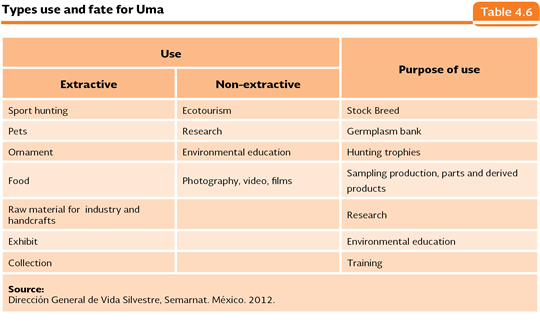
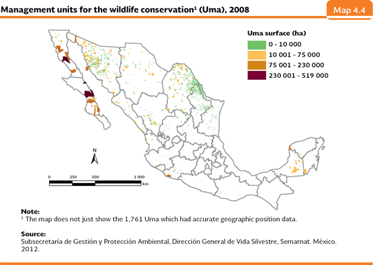
Management Units for the Wildlife Conservation In 1997, it was established the System of Management Units for the Wildlife Conservation (Suma). The objective of the Management Units for the Wildlife Conservation (Uma) is the conservation of the natural habitats and their environmental services, as well as the populations and specimens of the wildlife species, for restoration, protection, maintenance, recovery, reproduction, repopulation, reintroduction, research, rescue, shelter, rehabilitation, exhibition, environmental education and sustainable use purposes. The Suma records all those lands (named environmental management units, Uma), either privately owned, ejidal or communal, where conservation activities are exclusively carried out, or the type of conservations and sustainable use. The Suma also may record the government owned lands, including the national goods designated or licensed according to the law as long as they are aimed at conservation and sustainable use. There are two types of Uma, depending on their management conditions: they may be extensive type when there are specimens or populations of wildlife species within their natural ecosystems; or the type of intensive management when the specimens or populations are under confinement conditions. The Umas must work according to the management plan authorized by the Semarnat for their functioning, such plan is the operative technical document describing and scheduling the activities for the species management as well as their habitats; it also establishes the goals and success indicators of the Uma depending on the habitat and the populations it manages. Depending on the qualities and features of the products they manage, the Uma may be rated, according to its use, as extractive or non-extractive (Table 4.6).
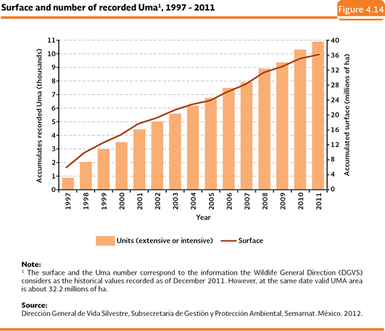
As of 2011, there were 10,855 recorded Uma (8,381 of free life management and 2,474 of intensive management) and an accumulated service of 36.1 million hectares5 (about 17% of the national territory; Figure 4.14). If the geographic distribution is analyzed, the Uma have been mainly established in the north of the country, being the states with the larger number of units recorded, in decreasing order, Nuevo León, Sonora, Tamaulipas, Coahuila and Durango (Map 4.4).
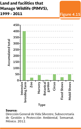
Under the terms established in the General Law of Wildlife and its Regulations, the lands and facilities that manage wildlife in a confined way, out of their natural habitat, which are not aimed at the recovery of the species or populations for their reincorporation to the wildlife, will not require the authorization of the Semarnat of their management plans and they are not considered as Uma, but as Lands and facilities that Manage Wildlife (PIMVS). In this category, about flora, the nursery and the botanical garden are also grouped; for the fauna, the intensive farms, zoos, circuses, fixed farms and travelling farms are considered. In the period 1999-2011 there were 590 PIMVs recorded, from which the largest part (67.8%) corresponded to intensive farms (Figure 4.15).
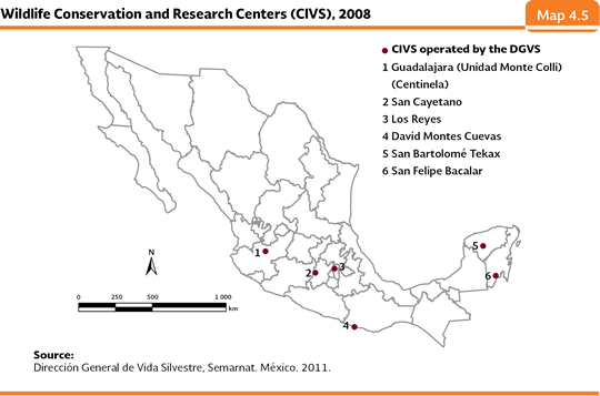
Centers for the Conservation and Research of Wildlife The Centers for the Conservation and Research of Wildlife (CIVS) are facilities that carry out activities of reception, rehabilitation, protection, recovery, reintroduction, reference and any other activity that contributes to the conservation of specimens which are a product of rescue, volunteer deliveries or seizures made by the General Attorney Office of the Republic (PGR). There are also activities of outreach, training, monitoring, evaluation, sampling, management, permanent follow up and any other activity that contributes to the development of the knowledge of the wildlife and its habitat, as well as the integration of these ones into the sustainable development processes. The six existing CIVS are managed by the Wildlife General Direction (DGVS) and they are located in the states Jalisco, Yucatán, Oaxaca, Quintana Roo and the State of Mexico (this last one has two centers; Map 4.5).
In the period 1998-2011, the CIVS received a total of 19,435 specimens, whose largest part was for reptiles (40.2%), followed by the birds (33%), mammals (10.7%) and arachnids (7.8%); the remaining 8.3% corresponded to amphibians, arthropods, cacti and fish (Table D3_BIODIV04_10). From the specimens entered in the CIVS in the same period, 3,298 specimens (about 17% of the entered ones), were released, out of which 34.1% were reptiles, 29.7% birds, 22.6% mammals and 13.1% arachnids.
4 The increase in the number of releases offspring reported in this work with respect to previous editions of the Report is caused by the recent adjustments in the information made by the National Program for the Conservation of the Marine Turtles of the Conanp. The fundamental reason is the inclusion, into the preexistent data, of the information from the Sanctuary Playa La Escobilla and from the Playa Morro Ayuta, both of them located in Oaxaca. It is important to note that such Sanctuary is the most important nesting area at an international level for the olive ridley turtle. 5 The surface and the number of Uma reported in the text correspond to the ones the Wildlife General Direction (DGVS) takes into consideration the historical values recorded by December 2011. However, at the same date valid UMA area is about 32.2 millions of ha.
|