| CHAPTER 3. SOILS |
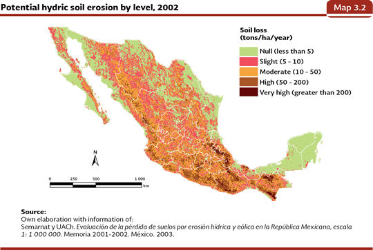
SOIL DEGRADATION IN MEXICO Soil is a fundamental part in the functioning of the ecosystems; important functions are carried out in the soil such as biogeochemical cycles and water catching (see Box The environmental services of soil). Its formation involves periods that can reach thousands of years, but its degradation can be sometimes irreversible, it can be carried out in terms considerably shorter. When we talk about soil degradation we refer to induced processes by human activities which cause a decreasing in its biological productivity or its biodiversity, and also its current or future ability to support human life (Oldeman, 1998). Due to the economic, politic and social importance of soil degradation, Mexico and the whole world have carried out several studies in order to assess how the surface is damaged, and of course, the type and damage degree. Our country has carried out several studies, but due to meteorological differences and to the scale used, their results are not comparable. The two most recent studies were carried out in the first years of the 21st century and they are Assessment of the loss of soils due to hydric and eolic erosion in the Mexican Republic, scale 1:1,000,000 (Semarnat y UACh, 2003) and Evaluation of Human-induced Soil Degradation in Mexican Republic scale 1: 250,000 (Semarnat y CP, 2003). The first study assessed in an indirect way the loss of soil by hydric and eolic erosion from cartographic information (i. e., of edaphology and precipitation) and from parametric models (Universal Soil Loss Equation and Eolic Erosion Equation) which were fed by some evaluated variables in soil samples. For its methodology, the resulting estimate is a measure of the potential degradation2 and not a direct study of the current degradation in the country. However, this approach, allows identifying the areas that are at a higher risk, and in this way contributes with the decision making on the use of soil in the framework of sustainable development in such a way that its degradation stops or decreases. The results of the work show that 42% of the national surface could be affected by hydric erosion, and 17 states would show damages in more than 50% of their territory, among them Guerrero (79.3%), Puebla (76.6%), Morelos (75.2%), Oaxaca (74.6%) and the State of Mexico (73.7%). The mountain range Sierras Madre Oriental, Occidental and Sur, as well as vast regions of Chiapas and central states of the country, would be at risk of presenting a high loss of soil caused by hydric erosion (Map 3.2).
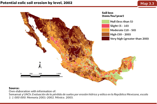
Regarding the potential eolic erosion, it was considered that 89% of the national territory would be in risk of damage. Practically 100% of the territory of Aguascalientes, Baja California, Baja California Sur, Sonora, Durango and Zacatecas, would have high potential eolic erosion what agrees with the types of vegetation and typical climates in the arid and semi-arid zones of the country. Only two entities showed less than 30% of its territory in risk of presenting eolic erosion: Chiapas (29.3%) and Distrito Federal (21.8%; Map 3.3).
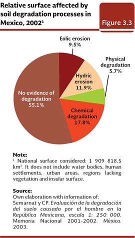
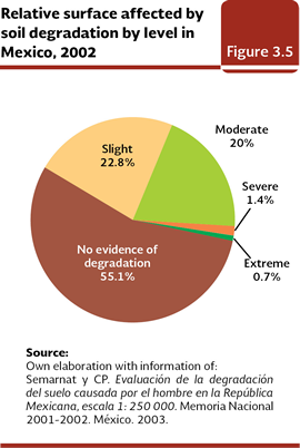
The second study brought in this Report is the Evaluation of Human-induced Soil Degradation in Mexican Republic (Semarnat y CP, 2003). It is the most recent one and the one with the highest level of resolution that has been done for Mexico, and unlike the previous one, it is sustained in a wide sampling in field that allowed determining, in a direct way, four processes of soil degradation: hydric and eolic erosion and physical and chemical degradation, as well as their reasons, specific types and affectation levels. The hydric erosion is defined as the laminate removal or in mass of the materials of the soil due to the action of the rainwater, which can deform the area and originate ducts and rills. In the eolic erosion, the erosive agent is the wind. The chemical degradation involves processes that lead to the decrease or elimination of the biological productivity of the soil and it is strongly associated with the presence of agricultural activities. The physical degradation refers to a change in the structure of the soil whose more eminent manifestation is the loss or decrease of its aptitude to absorb and store water. According to this assessment, 44.9% of the country soil was affected by some process of degradation, which is found in both natural zones ecosystems and managed ones. The chemical degradation took the first place (34.04 million hectares, 17.8% of the national territory), followed by the hydric erosion (22.72 million hectares, 11.9%), eolic (18.12 million hectares, 9.5%) and, at the end, the physical degradation (10.84 million hectares, 5.7%; Figure 3.3; IB 3.3, IC 13)3 . The soils without apparent degradation were found in 55.1% of the country (105.2 million hectares).
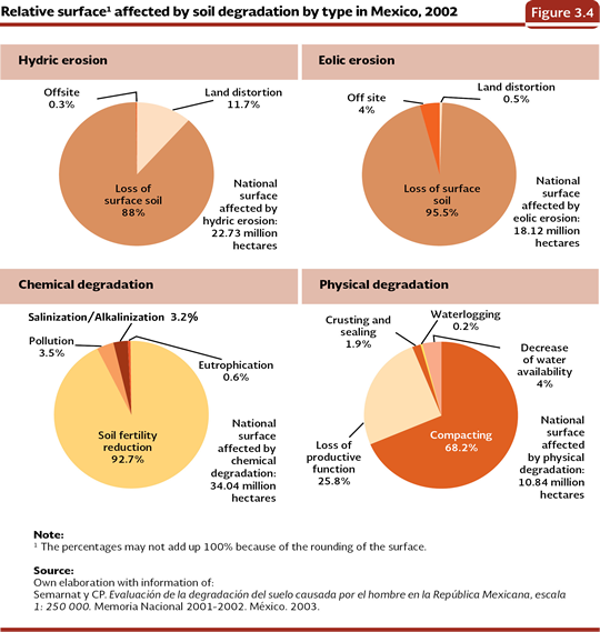
With regard to the subdivisions of the four big processes, both in the hydric erosion and in the eolic one, the specific dominant type was the loss of surface soil. In the case of the hydric one, it represented 88% of the national affected surface, and in the eolic one, 95.5%. In the chemical degradation the decrease of soil fertility was dominant (92.7% of the national surface with chemical degradation) and in the physical one, it was the compaction (68.2% of the national surface with physical degradation; Figure 3.4; Table D3_SUELO03_01).
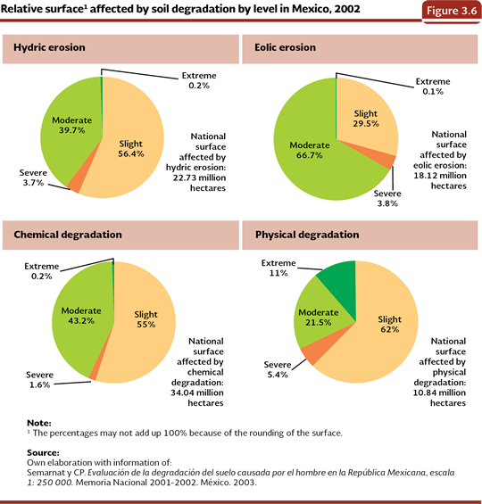
Another angle of analysis of the soil degradation is through the affectation level in which the plots are found, which was determined from the reduction of the biological productivity4 . Hereby, 2.1% (3.97 million hectares) of the country was placed in the levels from severe to extreme and 42.8% (81.78 million hectares) between slight and moderate (Figures 3.5; Table D3_SUELO03_01). As the processes and the levels of soil degradation are mixed, the result was that between 55 and 62% of the surface with chemical and physical degradation and hydric erosion were in a slight level, whereas for the case of the eolic erosion, the dominant level was the moderate one, since it was present in nearly 67% of the affected surface (Figure 3.6).
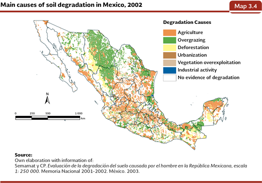
The reasons for degradation in the country soils involve activities of diverse nature: 35% of the national degraded surface is associated to the agricultural and livestock activities (17.5% for each one of them) and 7.4% to the vegetation cover loss. The rest is divided between urbanization, vegetation overexploitation and industrial activities (Map 3.4).
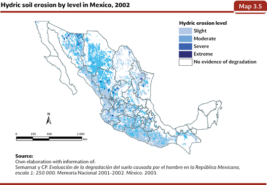
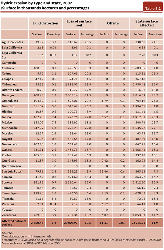
By virtue of the regional differences in the affectations of the different processes of soil degradation, in the following sections of this chapter there is a deep description of the characteristics, levels, geographical distribution and reasons of the four processes of soil degradation according to the Evaluation of Human-induced Soil Degradation in Mexican Republic in the Mexican Republic (Semarnat y CP, 2003). Hydric Erosion The complex topography of the national territory is a factor that, combined with the inadequate managing of the forestry, agricultural and livestock lands, can favor the run-offs that erode the superficial layers of the soil. The hydric erosion is divided in three types: land distortion, offsite effects and loss of surface soil. The latter one has serious consequences in the functions of the soil: it removes the nutriments and the organic matter, it reduces the depth of plant roots and it diminishes the rate of infiltration and water retention. The other two types of hydric erosion are closely related to each other. When the soil is dragged by water due the vegetal protection is not enough, ducts and rills are made. These deformations of the land allow the runoff of a large quantity of water and the sediment dragging that may reach dams, rivers or lagoons, among other water bodies, adding to their pollution, siltation and they even overflow flooding neighboring areas. This is known as hydric erosion offsite effects. 56.4% of the national surface with hydric erosion (22.73 million hectares) is in the slight level, 39.7% in the moderate level and 3.9% between severe and extreme (Figure 3.6, Map 3.5, Table D3_SUELO03_03). If it is analyzed at a state level, in proportion to their surface, Guerrero has the major affectation with 31.8% of its territory with hydric erosion; while Baja California Sur (0.03%), Baja California (0.1%) and Veracruz (0.1%) are among the least affected ones (Table 3.1).
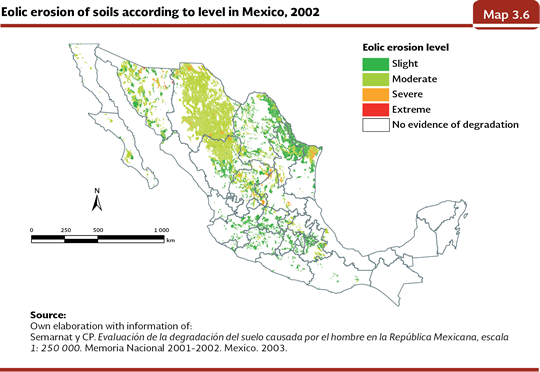
Eolic Erosion Eolic erosion mainly affects arid, semi-arid and dry sub-humid areas of the country; this is not an exclusive problem for these areas, though. The causes are also attributed to an insufficient protection of soil by its vegetation cover, to the destruction of the soil structure and to low levels of humidity. At a national scale, 18.12 million hectares (equivalent to 9.5% of the territory) show evidence of eolic erosion to 9.5% of the territory. With regard to the levels of affectation for this type of erosion, 66.7% out of the national total is in moderate level, 29.5% in slight and 3.9% between severe and extreme (Figure 3.6; Map 3.6; Table D3_SUELO3_03).
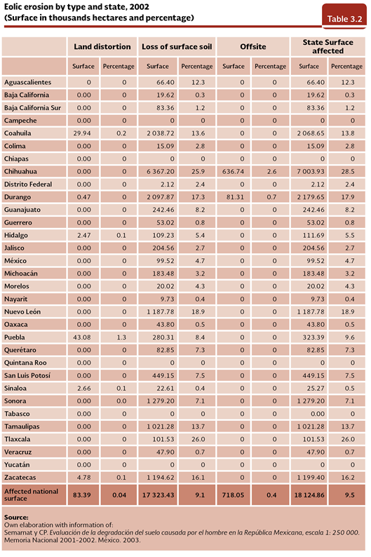
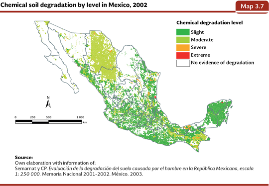
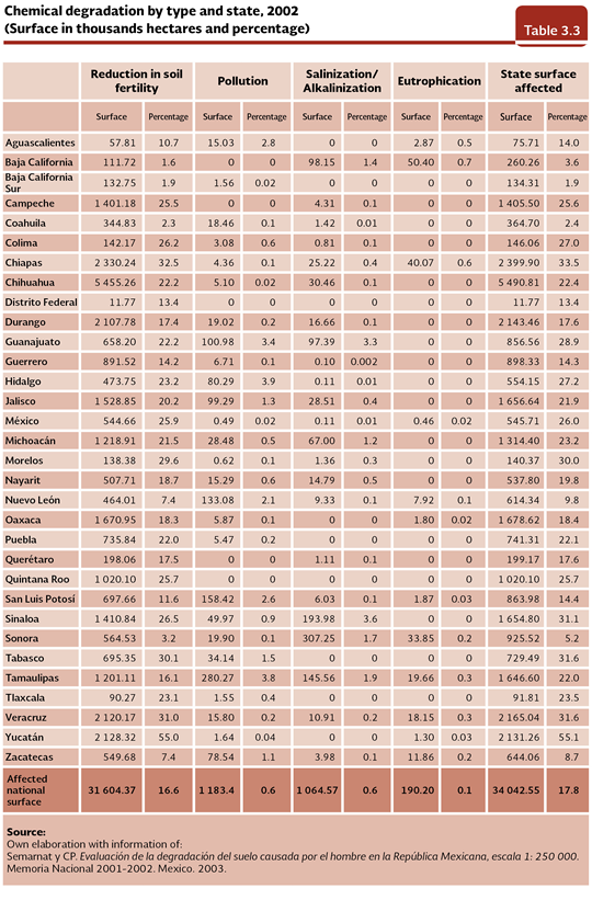
The specific types of eolic erosion are the same to those of the hydric erosion. In this case the loss of surface soil was also dominating, which affected 9.1% of the national territory. In the sites where there are signs of eolic erosion and its surroundings, the formation of dunes is common, which makes difficult the establishment and the development of vegetation. The states most affected states by the loss of surface soil in proportion to their surface were Tlaxcala (26%), Chihuahua (25.9%) and Nuevo León (18.9%). The other two types of eolic erosion, actually land distortion and the offsite effects, covered a little more than 800 thousand hectares, it means, 0.44% of the national territory. This surface was focused in the states of Chihuahua, Durango, Coahuila and Puebla (Table 3.2). An example of the importance of eolic erosion in its modality of offsite effects appeared in Distrito Federal during the decade of the 1950s, when large dust storms coming from the dry bed of the former Texcoco lake. The seasonal step of the winds of the North-East dragged particles of dust, organic matter and pathogenic microorganisms which caused health problems to the inhabitants of the Valley of Mexico Metropolitan Zone. Chemical Degradation The chemical degradation was the process of the most extended soil degradation in the country in 2002, with about 34.04 million hectares (17.8% of the territory). Regarding the degradation levels, the slight one is in 55% of the national surface with this type of degradation; the moderate one, in 43.2% and the severe and extreme together, accounted for 1.8% (Figure 3.6; Map 3.7; Table D3_SUELO03_03). If it is analyzed by state, we can see that it is in the whole country, from 1.9% of the state surface in Baja California Sur to 55.1% in Yucatán (Table 3.3).
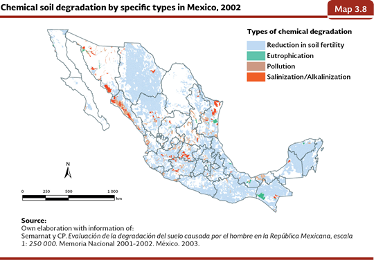
The types of chemical degradation recorded in the study were the reduction in soil fertility, pollution5, salinization/alkalinization and eutrophication. The reduction in soil fertility, understood as the net decrease of nutriments and organic matter available in the soil, it caused by a negative balance between the intake of nutriments and organic matter (via fertilization, conservation of the harvest waste and deposits of fertile sediments) and the outcomes (represented by the harvest products, burning or leaching), all this with important repercussions in the productivity of the soil. The reduction in soil fertility was the most important type of chemical degradation in the country, covering the 92.7% of the affected surface by chemical degradation. As an example, more than half of Yucatan soils, and almost a third of those in Tlaxcala, Chiapas, Morelos, Tabasco and Veracruz have this problem (Table 3.3; Map 3.8).
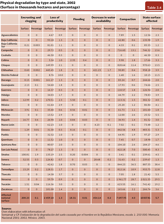
The remaining three specific types of chemical degradation are less widespread, occupying, as a whole, 7.3% of the surface with chemical degradation of the country, but this does not mean they are less important. The pollution is caused by the concentration and adverse biological effect of some substances that may come from open air dumps, spills, industrial waste, deposition of acidifying compounds and/or heavy metals. The salinization and alkalinization, by themselves, are represented by an increase in the salt content in the surface soil that generates, among other things, the decrease of the crop yields. Their probable causes include the intrusion of marine waters and the use of irrigation systems that use water with a high sodium concentration, which may cause the forming of a saltpetre layer in the surface of the soils which have deficient drainage, high evaporation, or are under excessive irrigation. The salinization or alkalinization appears mainly in the arid regions, in the closed basins and in the coastal areas that have naturally saline soils. The eutrophication is the excess of nutriments in soil that harms the vegetation development and it may be caused by the excessive application of chemical fertilizers. The pollution, salinization and eutrophication are mainly found in, Tamaulipas, San Luis Potosí, Chiapas, Nuevo León, Guanajuato, Sonora, Sinaloa and Zacatecas (Map 3.8). Physical Degradation The physical degradation is the least extended process in the country, since it affects nearly 6% of the national surface; however, it has a great impact because it is practically irreversible and leads to the loss in the productive function of the lands. At the state scale, the most affected one in relative terms to its territory, was Tabasco (38.4%) and the least affected entities were Coahuila, Sonora, Querétaro, Nuevo León and Michoacán with less than 2% each one of them (Table 3.4).
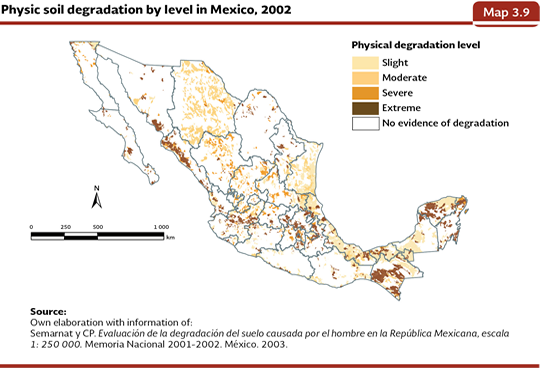
The physical degradation of soil may appear in five specific types: compaction, encrusting and clogging, flooding, decrease in water availability and loss of productivity. The compaction refers to the destruction of the soil structure6 and it is frequently associated to the cattle trampling or to the habitual track of heavy machinery. In the encrusting and clogging, the pores are filled with fine material, which prevents the infiltration of the rainwater, with the subsequent increase of the volume of the surface run-offs and the hydric erosion. Generally, this type of degradation is greater in areas with scarce vegetable cover and low content of organic matter, what increases the mechanical damage of the rain drops. Flooding is caused by the presence of a surface layer of water over the soil, which is frequently associated to the construction of irrigation dams. The opposite case to flooding is the decrease of the water availability, which is originated by its excessive extraction with agricultural purposes or for population supply, or for the decrease of the vegetable cover as well as of the organic matter of the soil. Finally, the loss of productivity function implies that the soils, as they are used in non-biological activities (for instance, infrastructure construction, mining or quarries) lose their productive function. The types of physical degradation with a greater presence in the country were the compaction and the loss of productivity with 4% and 1.3% of the national affected surface, respectively. The encrusting, flooding and the decrease in water availability affected, as a whole, 0.31% of the national territory. The most affected state by compaction, in terms related to its surface, was Tabasco (36.5%) and among the least affected ones are, Sonora, Sinaloa, Nuevo León, Chihuahua, Baja California and Baja California Sur with less than 1% each one of them. Regarding the loss of productive, the most affected state in relative terms to its surface was Distrito Federal (10%), while Campeche, Coahuila, Guerrero, Michoacán, Oaxaca, Sonora, Aguascalientes and Veracruz showed less than 1% of affectation in their territory (Table 3.4). Regarding the levels in the physical degradation, the extreme appeared in 1.2 million hectares (11% of the affected national surface); the severe one in 587 thousand (5.4%); the moderated one in 2.33 million (21.5%) and the slight one in 6.72 million (62%; Figure 3.6; Map 3.9, Table D3_SUELO03_03).
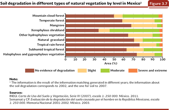
The soil degradation is the result of the interaction of environmental and human factors among which are the type of soil, topography, climate, deforestation, overgrazing, population density, the way the natural resources are used and the type and state of the vegetable cover. Regarding the latter factor, a part of the soils of the natural ecosystems presents signs of degradation in its different processes and levels (Figure 3.7). In the rainforests, temperate forests and mangroves, the dominant degradation level is the slight one; while in the xerophylous scrubs, mountain cloud forest and the natural grassland the moderate level is dominant. Nevertheless, in all of the vegetation types there may be extensions with severe and extreme degradation, especially when they are used as grassland areas.
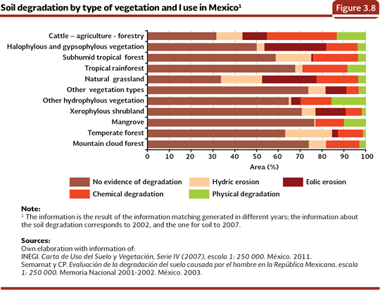
If it is considered the total surface of the natural ecosystems, the grassland and the halophylous and gypsophylous vegetation have the higher percentage of their soils degraded, with 66.1% and 49.7%, respectively, equivalent to 6.5 and 2.2 million affected hectares (Figure 3.8; Table D3_SUELO03_02 and D3_SUELO03_06; IB 3.3, IC 13).
Regarding the managed ecosystems, about 70% of the national surface dedicated to agriculture, livestock and cultivated forests, (about 35 million hectares) was affected by some specific type of degradation, being the chemical one, in its quality of fertility loss, the dominant type (Figure 3.8). This might be caused due the change of land use of the land that supported the natural vegetation was done without considering its agricultural potential, which could have caused the nutriments depletion. Notes: 2 The potential degradation is the forecast of the losses, dragging or transport of particles of soil that would take place in case of vegetable cover does not exist as a consequence of the effect combined of the rain, the runoffs, soil erodibility and the relief (Moreira-Madueño, 1991; Information Center of Natural Resources, 2010). 3 The percentages may be different from other ones due to the extent of the national surface considered for each analysis; in this case the surface was 1,909,818.5 km2 not including the water bodies, human settlements, urban areas, areas without vegetation and insular surface. 4Slight level: the suitable land for forest, cattle and agricultural local systems show some reduction scarcely perceptible in their productivity; moderate level: the suitable lands for forest, cattle and agricultural local systems show a marked reduction in their productivity; severe: lands in level of land or farm, they have such a severe degradation, which can be considered as irrecoverable productivity unless big works of engineering be carried out for its restoration; extreme: its productivity is irrecoverable and its restoration is materially impossible. 5 The pollution is different from contamination since the latter one is caused by a strange substance that does not produce adverse significant effects, while pollution does have them (Semarnat y CP, 2003). 6 It is about the arrangement of sand, silt and clay particles to make up compounds or soil aggregates. The particles remain clustered by roots or microbial activity products.
|