| La información más reciente sobre vegetación y cambio de uso del suelo en México, se encuentra en los Indicadores Básicos y Clave. |
| CHAPTER 2. TERRESTRIAL ECOSYSTEMS |
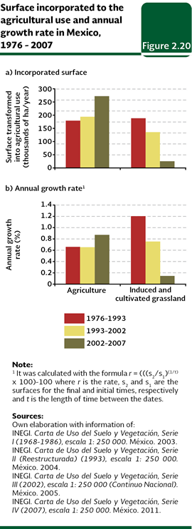
FACTORS RELATED TO CHANGES OF LAND USE There have been proposed different hypothesis about what factors are responsible of the change of land use. The most common and simple states that the growth of the population causes a higher demand of resources and in order to meet it becomes necessary that the areas occupied by the natural communities are substituted by land dedicated to farming, cattle rising or to any other productive activity. In spite of the acceptance of the fact that the growth of the population and its needs are important to explain the change of the land use, the relationship is not that simple. The population growth rates and the expansion of the agricultural border do not grow at the same speed: in the last decades, in general terms, the agricultural area has grown more slowly than the world population because, in part, the production has become more efficient. Other factors related to the population, like the growth of the urban areas also contribute to the changes in the land use, with a minor extent though. Population In general, there is a positive relationship between the population size and the area dedicated to the farming activities. Such relationship is more intense as long as there is a larger rural population engaged in the primary activities. For Mexico, the relationship is closer when the existing population from years back is taken into consideration. In fact, the highest relationship is found with the existing population in the 1950s (see Box The inertia of the past in the 2002 Edition of the Report). This historical divergence in the land use is, to some extent, a result of the changes in the structure of the occupation of the population. As a larger proportion of the population gives up working in primary activities, the relationship between the population density and the amount of soil used for the agriculture and cattle rising becomes dimmer. In such sense, the migrating movements and the abandonment of the countryside will have effects in the land use in the future. Furthermore, this behavior means that the changes now given in the features of the local population (particularly the one dedicated in primary activities) will probably be seen in the land use until several decades later. Growth of the agricultural border The conversion of lands towards agricultural and livestock raising uses is one of the most important reasons for deforestation in Latin America and the world (FAO, 2010). According to the information from the Secretariat of Agriculture, Livestock, Rural Development, Fisheries and Food (Sagarpa), the agricultural sown area in Mexico has relatively been steady between 1980 and 2010; it went from 18 to 23.3 million hectares, with an average of a little more than 21 million hectares (Table D2_AGRIGAN03_01). Notwithstanding, the Cartas de Uso del Suelo y Vegetación from the INEGI state that the agricultural area has been growing in the country, even faster than in the last years. While between 1976 and 1993 slightly more than 179 thousand hectares per year in average were changed, this figure reached 272 thousand hectares between 2002 and 2007 (Figure 2.20a). In this last period, the natural vegetation changed into agricultural lands, 31% came from sub humid tropical forests, 23% from xerophilous shrublands, 15% from temperate forests, 13% from natural pastures and 6% from humid tropical forests. In contrast, the growth of the areas assigned to livestock raising (cultivated or induced grassland) have dramatically decreased: the annual average of change between 2002 and 2007 was slightly more than seven times lower than what it was recorded between 1976 and 1993 (Figure 2.20b).
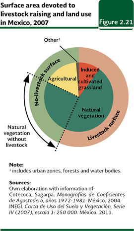
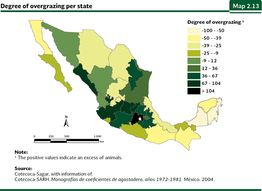
The livestock raising is practiced in all of the states in the country, covering, according to the information from the Technical Advisory Committee Rangeland Coefficients (Cotecoca, 2004), around 109.8 million hectares5, it means, about 56% of the total area of the country. Taking into consideration this estimate and considering that for 2007 the induced and cultivated pastures covered a little less than 19 million hectares (nearly 10% of the country), then the remaining 90.8 million hectares of livestock area should be found in the natural vegetation, with which just around 49 million hectares of natural vegetation (35% of the remnant area) could be free of livestock activities (Figure 2.21).
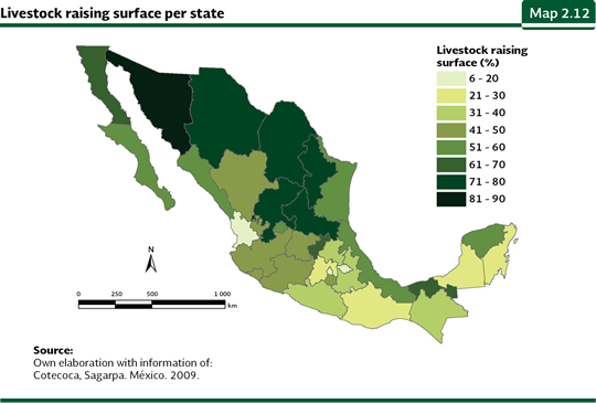
At a state level, according to the Cotecoca, the largest relative livestock areas are recorded in Sonora (83% of the state), Coahuila (77%), San Luis Potosí (74%), Chihuahua and Zacatecas (each one with 72%) and Nuevo León (71%). In contrast, the states with the lowest livestock covers are Nayarit (14%), Mexico City (11%) and Tlaxcala (6.5%; Map 2.12; Table D2_AGRIGAN4_02).
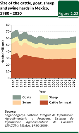
In the livestock production there has been a reduction in the number of heads of livestock during the last two decades. In 1980, 67.6 million heads were recorded (considering bovine cattle, goats, sheep and swine); while in 2010 4.8 million fewer heads were recorded (62.8 million). The most remarkable net decrease was observed in the cattle, which decreased from 34.6 million heads to 30.3 million heads (12.5%; on the other hand, the number of sheep increased 25% in respect to 1980 and the goats reduced 7% (Figure 2.22).
Urbanization Being true that at a national scale the urban area is proportionally smaller, it is the land use that is growing more rapidly in some regions of the country. By 2007, the urban area was little more than 1.56 million hectares, in other words, it was the 0.82% of the national area. In general, it is flat lands, proper for agriculture, which stop being productive. While the direct impact of the cities may be small at a local level, they indirectly affect the land uses of great extensions out of the urban area to meet the demands of food, timber, recreation and waste disposal of the population living there (see the BoxThe ecological footprint of Mexico in the chapter Population).
Note: 5 Although the data is for 1994, the information was reviewed in June 2009 by the Cotecoca, which determined an updating was not necessary. |