| La información más reciente sobre vegetación y cambio de uso del suelo en México, se encuentra en los Indicadores Básicos y Clave. |
| CHAPTER 2. TERRESTRIAL ECOSYSTEMS |
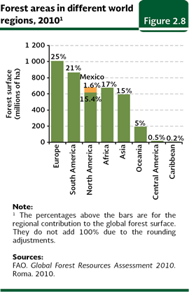
LAND USE CHANGE PROCESSES Some of the processes that determine land-use changes have been of particular interest. These include deforestation (the permanent change of a plant cover dominated by trees towards another lacking them3), alteration (also called degradation, which implies a modification of natural vegetation induced by man, but not representing a total elimination), and fragmentation (the transformation of landscape leaving small patches of the original vegetation surrounded by altered land). The land-use change in shrublands lacks a specific name, although sometimes it is denominated desertification, in the sense that it deals with the “environmental degradation in arid zones” (although desertification also includes subhumid areas). According to the General Law of Sustainable Forest Development, the country’s arid and subhumid shrublands are also regarded as forestal vegetation, so that the term deforestation may well be applied to these plant communities, even when deforestation is restricted to areas covered by trees according to several international organizations. Deforestation The main reasons of worldwide concern about the deforestation are about the loss of the biodiversity and the environmental services provided by temperate forests and tropical forests, as well as the global warming. Temperate forests provide services of great importance: they make and retain the soils avoiding erosion; they favor the water infiltration in the subsoil; they purify the water and the air; and they are a reservoir of a large biodiversity. Besides, they are a source of consumer goods such as wood, firewood and other “non-timber forest products” (such as food, fibers and medicine among some others). The major cause of global concern about deforestation deals with global warming and the loss of environmental services supplied by temperate and tropical forests. These ecosystems provide key services: generation and retention of soil in sloped land, thereby preventing erosion; facilitation of water infiltration to subsoil, feeding groundwater reservoirs; purifying water and air, and acting like biodiversity reservoirs. Furthermore, these are sources of consumer goods including timber, wood, food products and other “non-timber forest products” (food, fibers, and drug products, among others). According to FAO (2010), which considers that forests include no less than 10% of the total area covered by tree canopy, in 2010 forests covered slightly more than 4 thousand million hectares worldwide, in other words, about 31% of the Earth’s terrestrial regions. The main forest areas are located in Europe (25% of the world´s forests), followed by South America (21%) and North America (17%, with Mexico contributing with 1.6%; Figure 2.8).
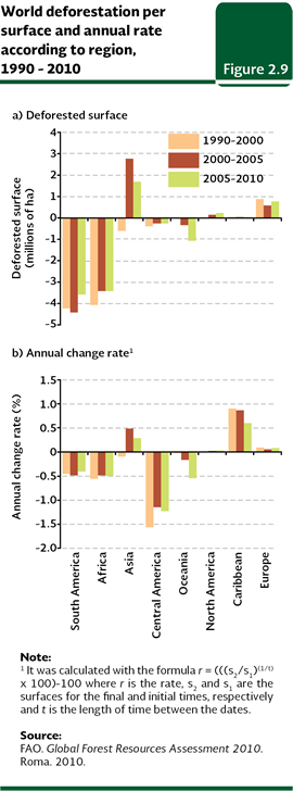
According to the above assessment, world deforestation, mostly to transform forests to farmland, have proceeded at high levels in the last decades. Although the net loss rate over the last ten years has dropped relative to the previous decade (1990-2000: 8.3 million hectares per year, at an annual rate of 0.2%), this loss remains high: for the period 2000-2005 it was calculated in 4.8 million hectares per year (at 0.12% annually) and for 2005-2010 it was increased to nearly 5.6 million (at 0.14% per year). In the period 1990-2010, South America was the region that lost the greatest forest area (12.2 million hectares); however, for the period 2005-2010 the forest loss was lower (3.6 million hectares; Figure 2.9a). In terms of net loss, it was followed by Africa (which between 1990 and 2010 reduced its cover in about 10.9 million hectares), Oceania (1.4 million hectares) and Central America (870 thousand hectares). In contrast, forest areas in Europe increased 2.2 million hectares in those 20 years, while in Asia and North America they started doing it since 2000, accumulating ten years after 4.5 million and 408 thousand hectares, respectively.
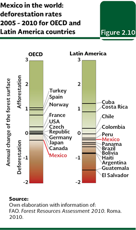
However, when comparison is made just considering deforestation rates, the picture is different. Central America, Oceania and Africa were the regions with the highest estimates for the period 2005-2010 (Figure 2.9b). Mexico is the only country, among the members of the Organisation for Economic Co-operation and Development (OECD) where the forests keep declining (Figure 2.10).
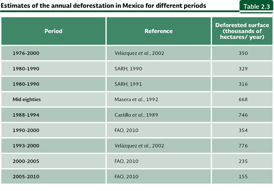
The issue of deforestation in Mexico involves a huge disparity in the estimates obtained from different sources. Only in the past twenty years the estimated figures range from 155 to nearly 800 thousand hectares per year (Table 2.3). The most recent and official change-rate estimates were published in Mexico´s National Reports elaborated by the National Forestry Commission (Conafor, in Spanish) in the context of the FAO´s Global Forest Resources Assessment (FRA) for 2000, 2005 and 2010 editions. Estimates were based on an especially explicit comparison of the forestal areas for the periods 1990-2000 (using INEGI’s Cartas de Uso del Suelo y Vegetación, Series II y III) and 2005-2010 (based on the Series III and IV).
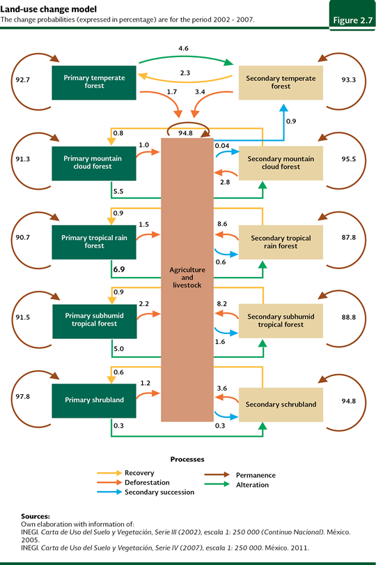
The most recent estimate reported to FAO, which covers the 2005-2010 period, reaches 155 thousand hectares deforested per year. In this way, according to the reports for FAO, between 1990 and 2010 a trend towards reduction of annually deforested area in the country can be observed: while between 1990 and 2000 the change-rate was calculated in 354 thousand hectares annually, this figure was reduced to 235 thousand and 155 thousand for the periods 2000-2005 and 2005-2010, respectively. Deforestation depends on a number of factors, but one of the most important driving forces is economy, which favors those activities that produce the highest short-term profit. Timber exploitation to meet market needs fosters deforestation, making intensive exploration profitable despite relative low prices. The economic models predict that timber prices promote a change in land use both when these are high – since forests are cleared for selling timber – and when prices are low – since there are no incentives to preserve forest areas. Likewise, the rise in farming product prices leads to deforestation, since the non-forestal uses of land are more profitable. Furthermore, the economic value of a given forest is low when selective timber extraction has depleted it from the most profitable tree species. Although this activity does not eliminate the forest cover immediately, it eventually results in deforestation, given that producers may get a higher profit by clearing impoverished forests to convert the land to other productive activities. This logic explains why perturbed temperate and tropical forests are later cleared and converted to land dedicated to farming activities in preference to primary vegetation. Alteration followed by deforestation is the most frequent land-use change process in Mexico, especially in the case of tropical forests (see Figure 2.7).
Similar to the global phenomenon, farming activities in Mexico have been identified as the main cause of deforestation, followed in importance by illegal clearing (although figures on this activity are necessarily incomplete and revealing huge differences depending on the source consulted). On the other hand, wildfires are also an important deforestation factor. Until a few years ago, an area subjected to fire does not recover, as it is immediately dedicated to other uses such as farming or urban development. For this reason, an important fraction of fires are clandestine, provoked for invading forest areas protected by law or other local institutions (refer to the section Additional threats to terrestrial ecosystems below for further details on wildfires and see the Box Deforestation and GHG emissions). Nowadays, when a forest area is burned, it may be restored after a while because authorities do not authorize land use change, what also attempts to promote the extinction of such practice.
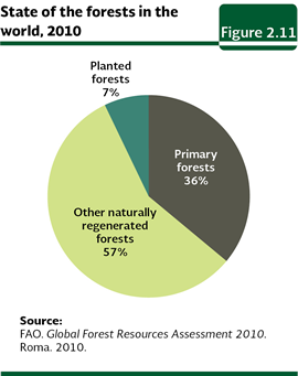
Alteration of temperate forests and tropical forests A less visible but maybe equally important process in terms of its environmental and economic effects is the degradation or alteration of temperate and tropical forests. Although this process does not involve the total clearance of the tree cover (as opposed to deforestation), it may lead to substantial changes in both the composition and density of species living in these ecosystems, which in turn affects their structure and functioning. The alteration of natural ecosystems also involves direct negative effects on environmental services, and hence on the possibility of a sustainable use. According to the most recent global assessment of forest resources (FAO, 2010) around 40 million hectares of primary forests have been lost worldwide since 2000, leaving 36% of the remaining area in this state (Figure 2.11). The case of Mexico is also cause for concern, since today only 36% and 62% of the country’s area is covered by primary tropical and temperate forests according to the Carta de Uso del Suelo y Vegetación Serie IV. On other hand, secondary vegetation (considering temperate and tropical forests) was on the rise at a rate close to 296 thousand hectares per year during the 2002-2007 period, with temperate forests being the ones suffering the heaviest degradation (nearly 181 thousand hectares per year), while tropical forests were degraded at a rate close to 115 thousand hectares per year.
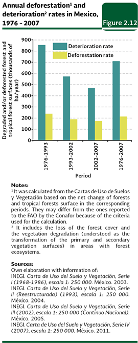
Both deforestation and alteration negatively affect the goods and services supplied by natural ecosystems. When deforestation and alteration are taken together, an approximation of the global vegetation “deterioration” rate can be derived. From the decade of 1970 to 2007, the annual deterioration rate (considering the deforestation plus the degradation) of temperate forests and tropical forests of the country was nearly 711 thousand hectares per year, it means, slightly more than three times the deforestation rate sensu stricto for that same period (213 thousand hectares per year; Figure 2.12).
The secondary forest vegetation currently covering large areas of the national territory results from both the regeneration of previously deforested land and the deterioration (with incomplete tree clearance) of primary vegetation. In the last years, the most important way for this process is the second one: between 2002 and 2007, 47% of the total area turned into secondary temperate a tropical forests came from the regeneration of agricultural lands and the other 53% came from the degradation of primary temperate and tropical forests. The alteration type most closely resembling deforestation is selective timber extraction. Unlike temperate forests, each hectare of tropical forest includes tenths of different tree species, most of which lack commercial value, so that their commercial exploitation is not profitable. Sparsely distributed amongst them are precious-wood trees including mahogany (Swietenia) and red cedar (Cedrella), which are cleared without making good use of the surrounding trees. Another way of exploiting trees is to obtain wood. Although the local prohibition of cutting trees for wood is common in Mexico, this practice continues because of the need for fuel. Nowadays, about 17% of country´s inhabitants use wood or coal to cooking (Presidencia de la República, 2011) and, although there are no data on the total amount of wood consumed, the area from which this is obtained must be enormous. Besides the direct damages caused by wood and precious-wood extraction, the tree-cutting process affects between 30% and 50% of the adjacent trees (Kartawinata, 1979 in Challenger, 1998), leading to their death or making them more susceptible to the attack of pests and diseases.
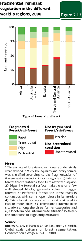
Fragmentation When the original vegetation is eliminated, usually small intact stands remain scattered within a heavily degraded matrix with different land uses. Each of these vegetation “islands” usually shelters a lower number of native species relative to an equivalent area located within a large extension of original vegetation. This is due to the fact that several of the native species cannot survive in small fragments, and that multiple degradation processes take place along the borders. For these reasons, when the aim is wildlife conservation, it is not sufficient to determine the area covered by vegetation. Having a single large extension of tropical forest comprising 100 thousand hectares is not equivalent to having one hundred fragments of one thousand hectares each. Ritters and coworkers (2000) reported the earliest fragmentation estimates for temperate and tropical forests at a world level. Figures are disturbing: a mere 35% of the forested land is neither fragmented (i.e., forming continuous areas of over 80 square kilometers) nor suffering border effects (that is, located more than 4.5 kilometers away from a border). At a regional level, Australia-Pacific displayed the highest proportion of fragmented forests worldwide (above 71%); and, taking into consideration the type of ecosystem, tropical forests were the most fragmented ecosystems (Figure 2.13).
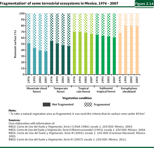
In the case of Mexico, rough estimates of natural vegetation fragmentation can be calculated using the different Series Cartas de Uso del Suelo y Vegetación. In order to determine the extent of ecosystem fragmentation, fragmented areas were regarded as those stands of natural vegetation with an area smaller than 80 square kilometers, considered as the minimum area suitable for maintaining optimal conditions for the diversity and the biological population in certain ecosystems (see Sánchez-Colón and collaborators, 2009). According to the Carta de Uso del Suelo y Vegetación Serie IV, in 2007 temperate forests (including temperate and mountain cloud forests) were the most fragmented forest ecosystems in the country: 54% of their remnant area (around 18.4 million hectares) was divided in fragments smaller than 80 square kilometers. When this vegetal formation is disaggregated, the picture worsens for some types of vegetation. Mountain cloud forest, in this year, was the most fragmented forest type, reaching 62% of its remnant area, which means 1.14 million hectares4 (Figure 2.14).
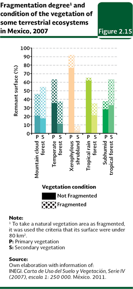
With respect to tropical forests, nearly 38% of their area is found in fragments smaller than 80 square kilometers (12.1 million hectares; Figure 2.14). In particular, subhumid tropical forests showed a lower continuity than the humid ones, with 39% and 34% of their fragmented area, respectively. Finally, shrublands showed the lowest fragmentation degree: nearly 80% of their area (40.1 million hectares) did not show evidence of such condition. Ecosystems fragmentation affects both primary and secondary vegetation. Large areas of primary vegetation remain in the form of fragments. This condition makes them vulnerable to degrade more rapidly, even without human intervention, than larger conserved areas. In 2007, fragmentation of primary vegetation was important for some ecosystems: 55% of remnant primary area of mountain cloud forests and 44% of temperate forests (Figure 2.15) were in such condition. Lower percentages, but not insignificant, were observed in humid and subhumid tropical forests (25 and 20% of their primary area, respectively) and shrublands (17%).
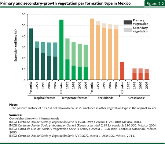
Shrubland degradation Shrublands, locally known as “huizachales” and “mezquitales”, characteristic of Mexico’s arid zones, have also been deteriorated by man. The rate at which arid shrublands are being converted into other land uses is even harder to assess than deforestation. According to national inventories, shrublands represent the ecosystem being transformed into other uses at the slowest pace and which is, therefore, preserved mostly as primary vegetation (91.5% in 2007 according to the Series IV; Figure 2.2). In absolute terms, however, this degradation level is not negligible, as secondary shrublands comprise more than 43 thousand square kilometers, an extension equivalent to Yucatán or Quintana Roo.
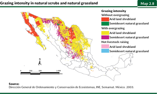
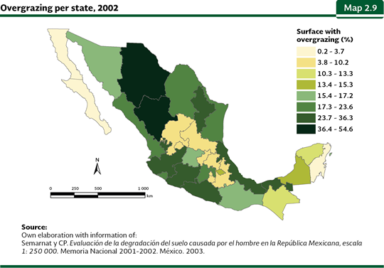
Shrublands may display important physiognomic variations, even within a small area. The vegetation resulting from an alteration in a given place may be perfectly natural in another. For this reason, it is extremely difficult to determine how the primary vegetation in any given location might have been, or if, alternatively, this actually represents secondary vegetation; this is most difficult if assessment are made based solely on remote sensing methods and when no direct field studies are available. Considering that most shrublands are used for cattle raising, an analysis conducted by the National Institute of Ecology (INE in Spanish; Semarnat, INE, 2003) using alternative techniques to determine degradation reveals that, in many municipalities across the country, the number of head of cattle exceeds the ecosystem’s maximum capacity, and that 70% of shrublands are overexploited, leading to degradation processes. This figure differs markedly from the 7 to 8% of secondary shrublands described in the Cartas de Uso del Suelo y Vegetación, Serie I (for the decade of the 1970s), Serie II (1993) and Serie III (2002). According to the INE investigation, only the shrublands of eastern Coahuila, the Altar Desert and central Baja California are not overgrazed. Overgrazing also affects 95% of Mexico’s natural grasslands, which grow predominantly in Mexico’s arid north (Map 2.8).
Semarnat, based on the study Assessment of soil degradation caused by man in Mexico (Semarnat-Colegio de Postgraduados, 2003), conducted an estimate of overgrazing by state in the country (Map 2.9); this study reveals by the year 2002, the area affected by overgrazing amounts to some 47.6 million hectares, equivalent to 24% of the national area and approximately 43% of the area dedicated to cattle-raising in the country. It is evident that degradation of the arid ecosystems in the country is still uncertain and specific studies are necessary to accurately estimate both the affected area and its extent.
Although wildfires are generally related to temperate forests, most of the affected area usually corresponds to grasslands, shrublands and arbustive vegetation. During 1998-2011, 84.5% of total burned area in the country corresponded to pastures and shrublands. Certain years may be particularly devastating for this type of vegetation: in 2011, in Coahuila, the burned area of shrublands reached slightly more than 272 thousand hectares, this is, 44.5% of the national burned area in that year. When all former factors act together, alone or in group, to alter the vegetal cover of a desert, its environmental conditions generally become rougher, at least drier and with higher temperatures. The plants and the animals that may survive in these modified environments are the typical ones from the most arid areas; therefore the place looks more deserted than in its original condition. Therefore the term desertification: “to make deserts”. The most accepted definition of desertification, proposed by the United Nations Convention to Combat Desertification (UNCCD), defines it as follows: “… it is the degradation of the lands in arid, semiarid and dry sub humid areas as a result of different factors, including the climate variations and the human activities”. Degradation involves both the plant cover and the soils supporting it (see also the section The desertification problem in the chapter Soils).
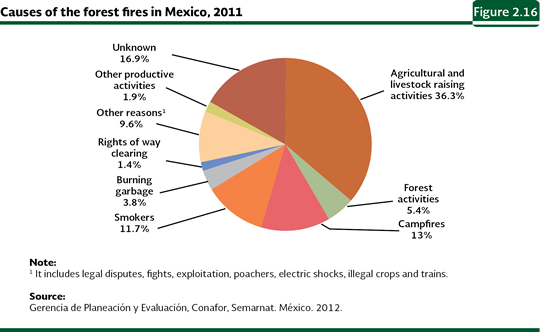
Additional threats to terrestrial ecosystems Forest fires In addition to the human activities mentioned before, the ecosystems are subject to their natural factors that may alter them, such as fires, droughts, landslides, invasive species, forest pests and extreme meteorological phenomena, such as hurricanes (Dale et al, 2001). In some cases, these factors magnify their impact in the ecosystems as they act synergistically with the human activities. The forest fires happen in a natural way and they are an important factor of the natural dynamics of many terrestrial ecosystems, especially in the temperate forests and some shrublands. Because of them, the availability of the nutrients in the soil is increased and the ecological succession processes are started and they help to the maintenance of biodiversity (Matthews et al., 2000; SCBD, 2001c). However, nowadays and mainly because of the activities and the human control, the natural patterns of fire occurrences have been modified. Nowadays, many of the forestry fires happen in areas where they did not happen before, while in the areas with periodical fire systems, the fires have been suppressed (SCBD, 2001c; Castillo et al., 2003). The effects the fires have over the ecosystems are diverse depending on their intensity and frequency. The most important direct effect is the removal of the standing plant biomass, which along with the removal of the sprouts of the population of the arboreal species, damage their populations and delay or interrupt the natural regeneration, in addition to favoring the invasion of pests and forest diseases (Matthews et al., 2000; Castillo et al., 2003). In the case of the fauna, its immediate direct effect may be the death (particularly of the organisms which have little capability of mobility), while among the indirect effects, it may be mentioned the loss and alteration of the habitat and the shortage of food (SCBD, 2001c; Castillo et al., 2003; Haltenhoff, 2005). All of the above may cause alterations in the trophic webs and in the natural balance of the ecosystems, which, in the mid and long term may lead to the reduction of the biodiversity and to the loss or degradation of its environmental services (SCBD, 2001c; Castillo et al., 2003). Another of their effects, but at a global level, is the release into the atmosphere of large amounts of carbon accumulated over time in the tree biomass, which contributed to increase the concentration of carbon dioxide and, as a consequence, to worsen the problem of the climate change. In the case of the ecosystems that own forestry resources subject or vulnerable to exploitation, the effects of the fires may be observed in two levels: on one side, in the deterioration and loss of the resources themselves and, on the other hand, in the detriment of the quality of the environment where they are located. In the case of the former, the heat of the fire causes the death of the tissues and deformation of trees, reducing timber quality (Castillo et al, 2003). The fire may also eliminate the sprouts of the population of the commercial species and to favor the invasion of pests and forest diseases (Matthews et al., 2000; Castillo et al., 2003). In both cases, the final result may be the reduction of the forestry production of the potential of an area to be used, with the derivate social and economic consequences. The factors that mainly have an influence in the fires in the terrestrial ecosystems in many countries is the sustained felling of forests and the use of fire to enable arable lands in the agricultural practices; however, they also happen because of campfires not properly extinguished or due to smokers, who, inadvertently throw the matches or the cigarette butts which are still lighted away to the soil with flammable material, among other causes. In Mexico, in 2011, the principal reasons for the forest fires were the burnings related to agricultural activities (36.3%), followed by the campfires (13%) and the smokers (11.7%; Figure 2.16).
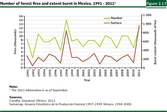
The number of fires that happened in Mexico and the damaged area has been kept relatively constant throughout the last fifteen years (Figure 2.17). Between 1991 and 2011, the annual average of fires was 8, 276 conflagrations, with an annual average damaged area of about 270 thousand hectares. However, in that period, in some years, the fires were particularly intense, as in 1998 and 2011, since Mexico and other areas in the world, recorded high figures: in the country, over those years, 14,445 and 12,113 fires were recorded, respectively, with a total damaged area of about 850 thousand and 956.4 thousand hectares, respectively. This area was equivalent to about three times the annual damage average between 1991 and 2011.
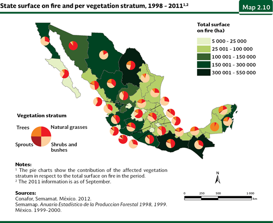
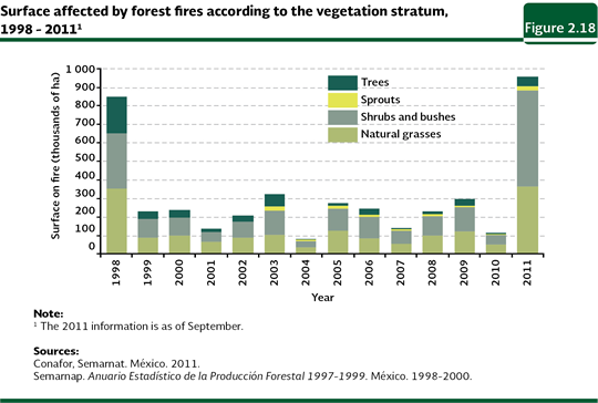
At the state level, between 1998 y 2011, the states that recorded the largest areas damaged by fires were Coahuila (around 547 thousand hectares; 13% national total in the period), Oaxaca (522 thousand hectares; 12%) and Chiapas (464 thousand hectares; 11%, Map 2.10; Table D3_REFORESTA05_02). In respect to the damaged area, the highest average was for the shrublands and bushes, followed by the pastures and the tree vegetation. In 2011, the averages for these types of vegetation were, respectively 55, 38 and 7%, (Figure 2.18; Table D3_REFORESTA05_03).
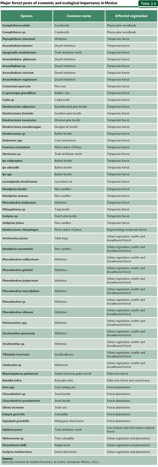
Pests and forestry diseases For the case of Mexico, the pests are considered as one of the main reasons for the disturbance in the temperate forests. Nowadays, there is a record of around 250 species of insects and pathogens which affect the woodland of the country, which some of them are shown in the Table 2.4.
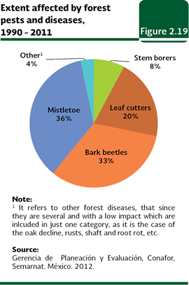
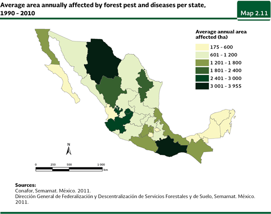
According to the periodical monitoring carried out by the Semarnat in the forestry areas of the country, in the 1990-2011 period, the average of the area annually damaged by pests and forestry diseases was 38,640 hectares. From the area damaged in this period, the highest share was for the mistletoes (36%), followed by bark beetles (33%), leaf cutters (20%) and stem borers (8%; Figure 2.19). The states with the highest average area affected by forestry diseases in that period were Oaxaca (3,955 hectares per year), Chihuahua (3,119 hectares), Aguascalientes (2,685 hectares) and Jalisco (2,645 hectares; Map 2.11).
Notes: 3 FAO defines deforestation as the permanent change in forest cover towards an area with a canopy cover lower than 10%, with the respective change in land use (FAO, 2010). 4 This figure may be influenced by the fact that the mountain cloud forest, just like other types of vegetation, is not distributed in a natural way in continues areas of large extent.
|