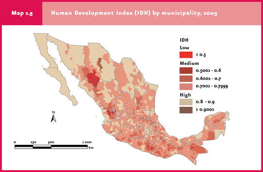
In 2005, 606 municipalities had a high HDI; 1844 municipalities had a medium HDI, and four had a low HDI. The highest HDI corresponded to the Benito Juarez district, Federal District (0.9509); the lowest, to Cochoapa el Grande, Guerrero (0.4354). |
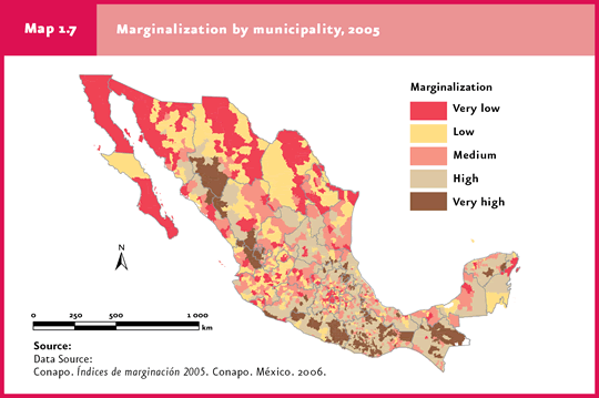
In 2005, 1254 municipalities had high and very high marginalization scores; 502, medium scores, and 698, low and very low scores. |
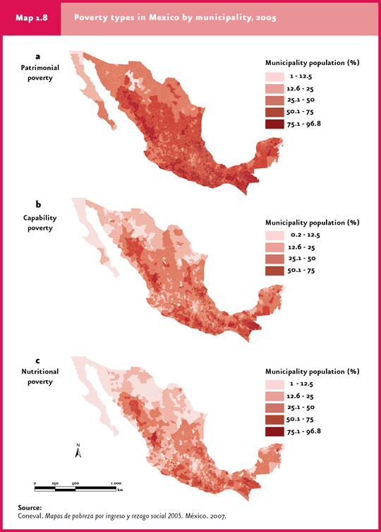
CONEVAL classifies poverty according to income, into: nutritional, capability and patrimonial poverty. |
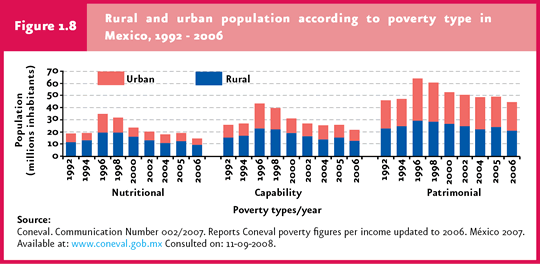
For 2006, CONEVAL estimated that there were 44.7 million people (42.6% of the country’s population) and 9.4 million households in patrimonial poverty, of which 14.4 million people (13.8% of the population) and 2.8 million households suffered nutritional poverty. The majority of these persons (9.4 million) and households (1.8 million) are located in rural zones. |
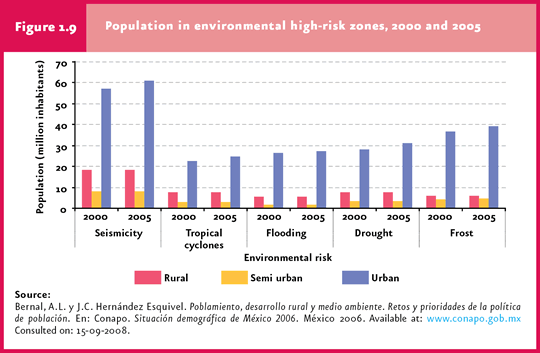
CONAPO estimated that, in 2005, 18.3 million inhabitants lived in rural municipalities located in some of Mexico’s seismic zones; about 5.6 million people lived in flood-prone municipalities, and 7.6 million people inhabited drought-prone areas. |
| CHAPTER 1. POPULATION AND ENVIRONMENT |
Similar to age-related variables and the geographical distribution of population, socioeconomic variables also display remarkable differences across the country. The variables included in this report are: Human Development Index (HDI), Marginality Index (MI) and poverty status.
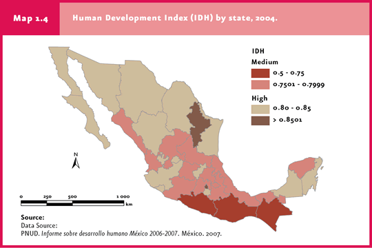
Human Development Index (HDI) The HDI was created by the United Nations Development Program (UNDP) and is used to rank countries or regions according to three basic population parameters: health, education and income. The result is a figure between 0 and 1, classified into three categories: low HDI, with values below 0.5; medium HDI, from 0.5 to 0.79, and high HDI, from 0.8 to 1 (UNDP, 2007a). At a state level, the Federal District and Nuevo Leon had the highest HDI in 2004 (0.8837 and 0.8513, respectively), while the lowest corresponded to Chiapas (0.7185) and Oaxaca (0.7336) (Map 1.4; UNDP, 2007b).
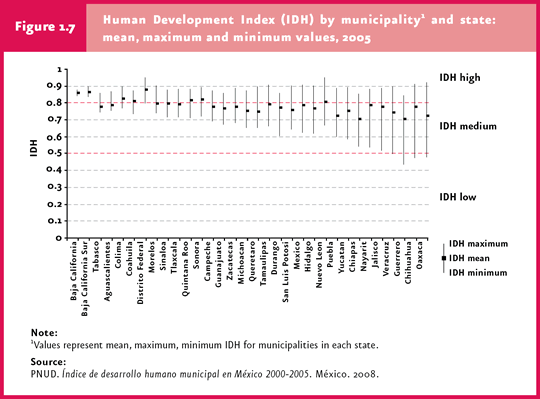
The differences in social development at a country level become more evident when the political division by municipalities and districts, as well as the presence of indigenous groups, is factored in. At the municipality level, the latest HDI figures correspond to 2005 and were published in 2008. The Benito Juarez district (Federal District), the San Pedro Garza Garcia municipality (Nuevo Leon) and the San Sebastian Tula municipality (Oaxaca) have the highest HDI in Mexico (0.9509, 0.95, 0.9204, respectively); by contrast, four municipalities are included in the low-HDI group: Tehuipango (Veracruz, 0.4985), Coicoyan de las Flores (Oaxaca, 0.4768), Batopilas (Chihuahua, 0.4734) and Cochoapa el Grande (Guerrero, 0.4354; Map 1.5). High-HDI municipalities fall within the same range as developed countries like the United States, Denmark, United Kingdom or New Zealand. In contrast, the low-HDI municipalities mentioned above are comparable to Sub-Saharan countries such as Eritrea, Nigeria, Angola or Zambia. The state displaying the smallest difference in social development between municipalities is Baja California, whereas Oaxaca displays the greatest difference (Figure 1.7; UNDP, 2008).
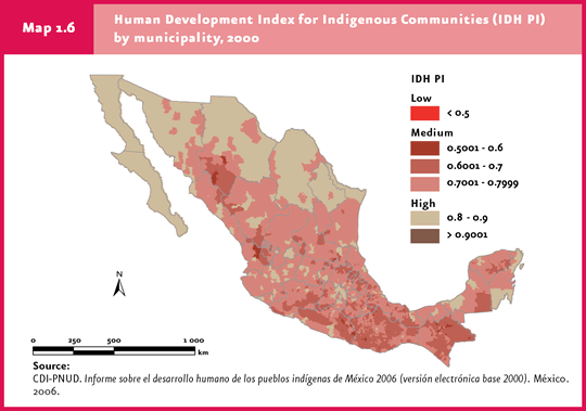
Mexico is a multicultural and multiethnic country where 68 language groups are spoken (DOF, 2008) and where around 10.2 million indigenous persons live (CDI-UNDP, 2006). In 2006, the First Report on Human Development of Indigenous People was published (HDI IP, with data from 2000), which reports a HDI of 0.7057 for this sector, far below the 2000 country average (0.794). It is worth noting that even within the indigenous population there are huge differences between groups and regions (CDI-UNDP, 2006). The place of residence and ethnic group are reflected in HDI IP values recorded across the country. In 11 municipalities, mostly inhabited by indigenous people, the estimated HDI IP is below 0.5. Coicoyan de las Flores, in Oaxaca’s Mixteca region, has the lowest HDI IP amongst all municipalities in Mexico (0.4455). Coicoyan is a rural municipality with over 98% indigenous population. The main economic activity is subsistence agriculture, and only a small part of the working-age population makes a living from trade and craftmaking. In contrast, the Benito Juarez district, in the Federal District, reported the highest HDI IP of Mexico (0.9242). In the year 2000, Benito Juarez was home to more than 10 thousand indigenous persons, who represented only 2.9% of the total population living in this district. Unlike low HDI IP municipalities, Benito Juarez is located in a wealthy urban zone (Map 1.6).
Areas inhabited by a large percentage of indigenous population also include an important portion of the country’s best preserved temperate and tropical forests, as well as the upper drainage basins of the major rivers. Unfortunately, indigenous communities have frequently been excluded from national development programs. As a result, it is not surprising that municipalities with the highest marginalization and poverty indexes match those displaying the lowest human development indexes. Nonetheless, many indigenous groups preserve their traditional knowledge in managing natural resources; thus, the explicit involvement of this population sector in environmental public policies is key when policies aimed to achieve sustainable development are to be designed.
Marginalization Index (IM) The marginalization index (MI) differs from HDI in that the former scores a given population according to its needs in terms of education, housing, income and population distribution. The MI calculation may yield positive or negative values. The higher the MI, the greater the marginalization. In 2005, the MI of the 2454 existing municipalities in Mexico confirmed the inequality evidenced by HDI. In general terms, municipalities with a low HDI have also a high marginalization score. In the same year, 1254 municipalities had a high or very high marginalization score, and were inhabited by 17 million people (16.5% of Mexico’s population). The group of municipalities with medium marginalization scores rose to 502, with 11.9 million people (11.6% of the population). The remaining 698 municipalities, with 74.3 million people (72% of Mexico’s population) have low or very low marginalization scores (CONAPO, 2006 b). The recently created municipality, Cochoapa el Grande, Guerrero, is the political-administrative unit with the greatest marginalization in Mexico. Its population is slightly above 15 thousand people; 76% of the inhabitants aged 15 and over are illiterate, and 88% did not finish elementary school; 95% of people live in houses with unpaved floor and lacking drainage and toilet facilities; six out of ten persons live in houses with neither electricity nor drinking water; 83% of households are overcrowded to some extent; 77% of the population lives in localities of less than 700 residents, and 87% of workers earn two minimum wages maximum. The lowest marginalization scores in Mexico were found in Benito Juarez (Federal District), home to more than 350 thousand people; only 1% of the population aged 15 years and over is illiterate, and less than 0.2% of its residents live in houses with unpaved floor or lacking drainage or electricity (Map 1.7)
Poverty Poverty is the third socioeconomic indicator in the Mexican population. The National Council for Evaluation of Social Development Policy(Consejo Nacional de Evaluación de la Política de Desarrollo Social, CONEVAL) is the agency in charge of measuring poverty, and categorizes it into three types:
For 2006, CONEVAL estimated that there were 44.7 million people (42.6% of the country’s population) and 9.4 million households under patrimonial poverty, of which 14.4 million people (13.8% of the population) and 2.8 million households suffered nutritional poverty. The majority of these persons (9.4 million) and households (1.8 million) are located in rural zones (Figure 1.8; CONEVAL, 2007b).
In 2005, poverty measurements revealed that there were 1856 municipalities with more than 50% of its population under patrimonial poverty (Map 1.8a); 780 municipalities with more than 50% of its population under capability poverty (Map 1.8b), and 503 municipalities with more than 50% of its population under nutritional poverty (Map 1.8c; CONEVAL, 2007a).
The poorest municipalities with the greatest social lag are found in the same hard-to-access mountainous regions with low HDI and high MI. The scattered distribution and remoteness of these towns restrain social development, since the lack of household sanitation and the scarce availability of healthcare services are closely linked to community location and size. Sixty two percent of Mexico’s indigenous language-speaking population inhabits rural communities of less than 2500 inhabitants.
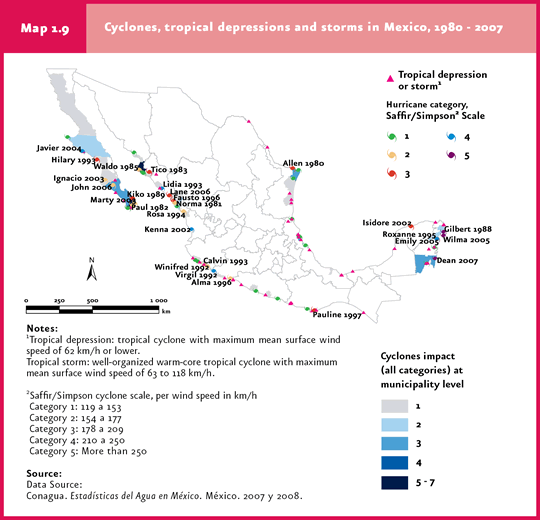
Population living in environmental high-risk zones Poverty that affects the majority of the rural population involves poor housing, social and transportation infrastructure which, added to deforestation, soil loss and the scattered distribution and settlement of new villages in unsuitable areas, jointly lead to an increase in population vulnerability when natural disasters occur, such as cyclones, floods, droughts and frosts. In 2005, 18.3 million people lived in rural municipalities located in some of Mexico’s seismic zones. Of them, 6.2 million lived in the highest seismicity areas across the Pacific and Central regions. Separately, floods cause heavy damage to rural communities. This phenomenon occurs as a result of excessive rainfall, floods from rivers and water bodies or sea storm surges. About 5.6 million people live in municipalities likely to be affected by floods. These municipalities are located primarily in Sinaloa, Durango, Sonora, Nayarit, Jalisco, Tamaulipas, Veracruz, Guerrero, Oaxaca, Chiapas and Tabasco. In contrast, 7.6 million people are estimated to live in drought-prone areas in northern and central Mexico, 4.6 million of which are highly marginalized (Figure 1.9). Tropical cyclones also represent hydrometeorological phenomena of considerable importance. It has been estimated that 560 rural municipalities located along or near the littoral are likely to be negatively affected. The most exposed zones are located in the Yucatan Peninsula and along the coasts of Tamaulipas, Veracruz, Jalisco, Colima, Michoacan, Guerrero, Baja California Sur and Sinaloa (Figure 1.9, Map 1.9).
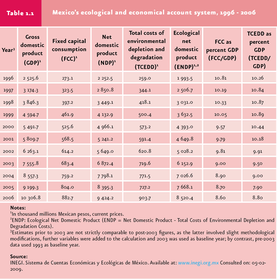
Economy and Environment For a long time, environmental deterioration was deemed an unavoidable cost of economic development and a necessary condition to overcome poverty; environmental issues would be dealt with once the economic and social difficulties were solved. Fortunately, this concept on the preeminence of man over the natural environment which arose during the Industrial Revolution and underlying the irrational exploitation of natural resources, is currently being replaced by the acknowledgement that human welfare depends on healthy ecosystems. The perception of natural resources as “free everlasting goods” is changing towards the relatively recent awareness that these are scarce and that today’s exploitation rate negatively affects its availability and, hence, sustained economic productivity, with negative effects on human health and welfare. Often times, the focus in sustaining economic growth is maintained at the expense of short- and mid-term environmental costs derived from economic activities. In Mexico, the National Institute of Statistics, Geography and Information Sciences (Instituto Nacional de Estadística, Geografía e Informática, INEGI) has estimated the economic costs of environmental deterioration and natural resource depletion that have taken place in Mexico in recent years. From 1996 to 2006, the total cost of natural resource depletion and environmental deterioration (CTADA, by its initials in Spanish) underwent a 3.5-fold increase, from $259 thousand million to $903.7 thousand million Mexican pesos, equivalent to about 10% of the GDP (Table 1.1), an excessively high cost for Mexico’s development.
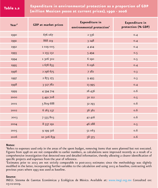
When CTADA is compared with the government’s environmental-protection expenses (Table 1.2), the imbalance between natural capital losses and investment in protection and recovery becomes evident. Although the federal expenditure in areas like reforestation and sustainable forest management has increased considerably over the past years through initiatives like the ProÁrbol program, the consolidation of the National Commission of Protected Natural Areas (Comisión Nacional de Áreas Naturales Protegidas) and the rational management of water resources, the need to reduce the environmental costs associated to the country’s development is imperative. In this context, these costs should be incorporated into the production processes; furthermore, the practice of incorporating cost-benefit studies explicitly considering the value of the environment and ecosystem services in project development should be encouraged. For example, a feasibility and adequacy analysis for the development of tourist resorts in mangrove or coastal ecosystems should include, among other aspects, the economic and environmental costs of a potential reduction in fishing activities linked to these ecosystems, or the increase in coastal vulnerability to meteorological phenomena.
|